Collegiate Fourteeners
Started: 2008-07-29 19:20:00
Submitted: 2008-08-01 11:18:50
Visibility: World-readable
Last week, my external constraints kept me at home early in the week (to do laundry and clean up after my previous weekend's expedition and to adequately plan my next expedition) and back at home for a friend's party for the weekend, which left only three days to go into the mountains. I studied my guidebooks (which collected in great numbers, from my personal collection as well as every library system within easy reach, on the end table in the living room) and decided that I wanted to undertake some fourteeners from a car-camping base camp.
Wednesday, 23 July 2008
On Wednesday, I set out from home in the early afternoon and headed up I-70, through the Eisenhower Tunnel, and turned south toward Leadville via Fremont Pass. I stopped at the pass to marvel at the tailing ponds left over from the Climax molybdenum mine, the latest in Leadville's boom-and-bust mining cycles, though apparently one that actually left money for environmental cleanup. I descended into the headwaters of the Arkansas River, drove through Leadville, identified Colorado's two highest peaks, Mount Elbert and Mount Massive, from town, and presently located Lakeview Campground above Twin Lakes Reservoir off CO-82 east of Independence Pass and Aspen. I had no trouble finding a spot; the campground was nearly empty in the middle of the week. I self-registered for my campsite and started heating water for supper when it started raining. When I had a liter of boiling water, I retreated to the back of Motoko to eat the backpacking meal I brought. This reminded me of my earliest memory: camping in the back of my father's red Toyota pickup shortly before my sister was born, when I was two and he was a few years older than I am now.
The rain was still going strong when I finished eating, so I read The Economist (Kiesa checks out two-week-old issues when they become available) as daylight faded. By 20:00, the rain had subsided enough that I was able to put up the tent. I studied my hike for the next day, started reading next month's sci-fi book club book, Crystal Soldier, and went to bed early.
Thursday, 24 July 2008
I woke up at 0600 on Thursday morning, as the rising sun was casting red light on the nearby mountains. I ate breakfast and drove down US-24 to the Missouri Gulch trailhead. Along the way, I caught enough NPR to hear good news about my future employer: Qualcomm and Nokia had settled their lawsuit regarding patent licensing. The trailhead was packed at 0730; I found a space, packed my day pack, and headed up the trail.
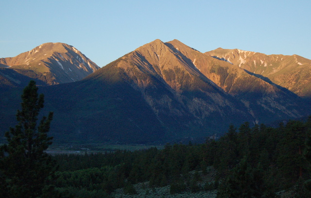
My first peak was Missouri Mountain. The trail switch-backed up the valley wall, then headed south into the heavily-wooded Missouri Gulch. I eventually broke above treeline, giving me a great view of the hoard of intrepid peak-baggers climbing Mount Belford's north-west ridge. I continued up Missouri Gulch to the end, then turned right to climb to the long north ridge of Missouri Mountain. I followed the ridge the rest of the way to the summit.

I reached the 14,067 foot summit of Missouri Mountain around 1100. It was the first fourteener I had climbed since Mount Bierstadt a year ago, and the highest I had stood (on solid ground) since my disastrous experience with hypoxia on the summit of Grays Peak three years ago. (This year, I carefully increased my elevation by not more than a thousand feet per expedition to make sure I was prepared to breathe the rarefied air at fourteen thousand feet above sea level.)

I signed the summit register, talked to the two women who were at the summit when I arrived (mother and thirty-something daughter, if I had to guess), and studied the surrounding peaks. I could see Mount Belford across Missouri Gulch to the east, Mount Harvard and Mount Columbia to the south-east, Mount Huron to the west, and Mount Elbert to the north. I saw plenty of peaks I couldn't recognize; it was all I could do to guess what range I was looking at. It's fair to say I could spend a lifetime climbing mountains in Colorado and never get bored.

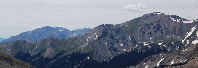
I left the summit and descended the way I ascended as far as the top of Missouri Gulch, then ascended to Elkhead Pass and continued up the broad south ridge of Mount Belford. Just short of the summit, I looked east along the ridge to Mount Oxford and west to the clouds rolling in. A massive storm threatened Mount Harvard to the south, but nothing coming towards me looked likely to hold too much rain or lightning. The ridge to Mount Oxford looked much longer and deeper than it had on my map. I faltered at the top for a minute before deciding to go for broke and try to ascend all three fourteeners in a single, very long day.
As I descended the ridge towards Mount Oxford, I got the first sign that I may have made a major mistake: I ran out of water, two thousand feet above the nearest stream. (I carried three liters in my Camelbak, a liter of Gatorade, and my water filter.) I continued my descent, knowing that every step I took down would be two more steps I would have to take up when I retraced my steps towards the trailhead. I made it half way up the ridge to Mount Oxford when I heard cloud-to-cloud lightning above me and noticed Mount Harvard shrouded in rain. I dropped my pack a hundred meters from the summit, tagged the highest point (14,153 feet, my new highest point since Grays Peak), marked a waypoint in my GPS receiver, signed the register, and hurried down to safer terrain. I found a semi-sheltered point two-thirds of the way down to the saddle and snacked and rested for half an hour before continuing down the ridge and climbing back towards Mount Belford.
I studied the map to determine whether descending to the north into the valley between Mount Oxford and Mount Belford would be a suitable escape route and decided that it could be worse, but the valley provided no obvious way to return to the Missouri Gulch trailhead. I continued up the ridge to Mount Belford, eventually reaching the point where I turned off to climb Mount Oxford, and continued to the summit proper. I signed the register but didn't take any time to bask in the glory of yet another highest point achieved since Grays Peak three years ago, 14,197 feet above sea level.
I descended along the most direct route to the trailhead, along a lengthy series of switchbacks down the north-west ridge. Clouds rolled in and began triggering cloud-to-cloud strikes. I reached running water as it started to rain. I pumped drinking water and cursed myself for not making sure to avoid dehydration. I felt vaguely nauseated since Mount Oxford, which I attributed more to dehydration than hypoxia, but they do tend to work together to make me feel lousy if I'm not careful.
The rain hit in earnest as I hit timberline and continued as I descended to the trailhead. I reached the trailhead roughly eleven hours after I set out, having traveled nearly sixteen miles and climbed 7,400 vertical feet.
It continued raining as I drove back to US-24 and headed for camp. I didn't want to deal with another rainy meal in the back of my car, so I drove into Leadville in search of food. I looked around in my car and on foot before settling upon High Mountain Pies, a scruffy-looking pizza place doing brisk business on a Thursday night. The had only three tables inside, which filled with tourists (including me) and seemed to have a brisk delivery business with the locals.

I returned to my campsite, chatted briefly with a camping neighbor from Texas, reviewed my plan for the next day, continued reading Crystal Soldier, and went to bed.
Friday, 25 July 2008
I woke up at 0600 on Friday morning and heard what sounded like an early-morning religious service, complete with singing and a talk, from somewhere south-west of my campsite, but I couldn't find any visual evidence of the service.
I ate breakfast and broke camp; since I was car camping, I didn't have to worry that the tent was still wet from me and from the morning dew; I tossed the tent, rain fly, and ground sheet in the back of my car and drove off, leaving the mess to clean up at home.
I drove south to Buena Vista, missed my turn to the North Cottonwood Trailhead, turned around, and eventually found the trailhead at the end of a three-mile high-clearance road. I parked, shouldered my pack, and headed up the trail at 0830.
I was a bit late to catch the hard-core peak-bagging crowd and too early for the incoming backpackers, but I did cross paths with a number of outgoing backpackers leaving the wilderness. When I turned onto the trail that dead-ends at Mount Elbert, I didn't see anyone until I hit treeline and got a great view of Mount Harvard to the north, Mount Columbia to the east, and Mount Yale to the south. (Mount Yale was the second fourteener I climbed, shortly before the beginning of my senior year at Fairview in 1997.)
I continued up the dead-end canyon. Mindful of my experience yesterday, I filled my water containers at what looked like the last running water at the end of the canyon. I climbed up a trail carefully arranged through talus and switch-backed up the mountain. I watched the elevation display on my GPS receiver and noticed when I climbed through 14,000 feet and when I passed 14,260 feet -- the altitude of Grays Peak, the highest I have ever been. I slowly climbed the remaining distance to the summit of Colorado's third-highest peak. I reached the 14,420 foot summit at 1300, marking the highest I have ever stood (on solid ground).
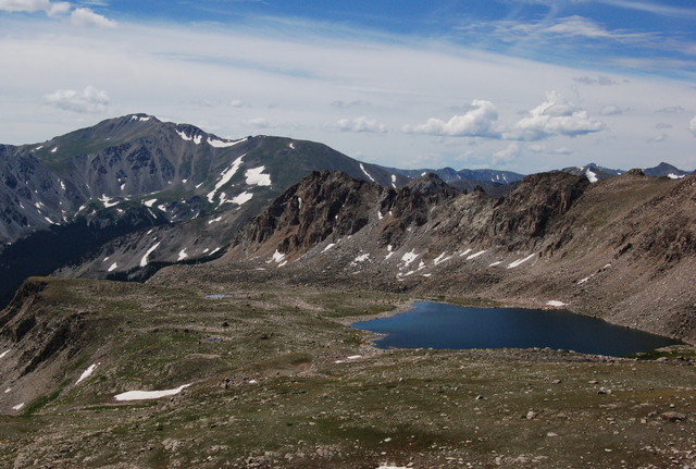
I ate lunch, searched unsuccessfully for a summit register, and enjoyed my accomplishment. My early plan had been to continue to Mount Columbia, but I scrubbed that plan due to the late hour even before I reached Mount Harvard. I descended the way I came, which wasn't quite as hard as the ascent, since I had gravity on my side, but was still hard work. Clouds rolled in as I descended but never actually rained but for a brief sprinkle when I was still a mile from the trailhead.
I eventually reached my car, late in the day, and headed home via US-285. It finally started raining as I drove home through South Park and kept raining until I was approaching Denver. While driving through Bailey, just as the highway turned north and began climbing out of town, I recognized the spot where my father pulled over to rest after we climbed Mount Sherman fourteen or fifteen years ago. (It seemed auspicious to recognize this connection to my first fourteener while returning from another mountain-climbing expedition.)
In two days, I climbed four fourteeners, almost as many as the five I have climbed in my life prior to this point. I would call it a successful expedition.
