Flying over Donetsk
Started: 2014-07-22 20:12:03
Submitted: 2014-07-22 21:00:58
Visibility: World-readable
In which the intrepid narrator realizes he's flown near the restive Donetsk People's Republic
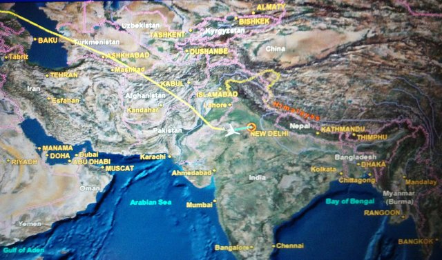
Two years ago I flew to India on United flight 82 from Newark to Delhi. I didn't pay very much attention to my flight's routing over Europe, mostly since I managed to sleep between the North Atlantic and Central Asia, aside from waking up briefly over Germany. I was fascinated by my flight's routing through Central and South Asia: we flew just north of the border between Iran and Turkmenistan, and then flew over Afghanistan and Pakistan on our way into India. (On my first flight to India I flew straight over Kabul.) Afghanistan was then (and still is) very much a war zone, and Pakistan is not exactly stable, but it would be nearly impossible to get to India from Europe or North America by air without flying over one or both countries.
One country that I barely noticed flying over was Ukraine, which was, at the time, stable (if not entirely pleasant). I thought, at various points in time, of stitching together the various sources I had for my flight route together to try to figure out where exactly I'd flown, but I never quite got around to it. Until I was reading an article this afternoon about Malaysia Airlines Flight 17, which was just shot down over eastern Ukraine, and noticed on the accompanying map that the most direct route between Germany and Turkmenistan went straight over eastern Ukraine.
I have three separate sources for my flight route: the track I grabbed from FlightAware.com shortly after my flight; the photo above, which I took of the in-flight map; and my vague recollection of glimpsing the in-flight map over Europe. (I do have two very-blurry photos of the full route from the in-flight map, but it's so blurry as to be pretty much useless, except to confirm that we didn't take any giant dog-legs.) The FlightAware track stops roughly in the vicinity of Dover, on the south-east coast of England, and the photo doesn't start up until the Caspian Sea, but it's pretty easy to line those two lines up on a map and draw a straight line between them, and that line takes me straight over Ukraine. The line goes a little south of Donetsk and their Donetsk People's Republic, but still close enough to be within the FAA's current no-fly zone for US-flagged carriers, and the Ukrainian government's own restricted airspace.
At the time, of course, no one knew that, two years later, there'd be an active insurgency in eastern Ukraine, complete with surface-to-air missiles capable of shooting down an airliner in flight. Now we know, and I don't think the world will be quite the same again.
If/when the embedded map above goes stale, these links might help:
