Never Summer Wilderness (part 1)
Started: 2008-07-30 20:14:00
Submitted: 2008-08-01 22:07:57
Visibility: World-readable
My constraints for my list week off before starting my shiny new job at Qualcomm led me to consider an expedition early in the week, since I was already home for the weekend (which generally gives me enough time to unpack, do laundry, plan my next expedition, and repack) and because Kiesa and I will be going out of town this coming weekend to celebrate our sixth anniversary. (Kiesa left the details to me. After considering a number of possibilities, I decided to drive to Glenwood Springs for hot springs and to bike up Glenwood Canyon. This will give us a chance to use our bikes as well as the shiny bike rack I installed on Motoko in May and haven't yet used.) This left me to plan two expeditions simultaneously. Mount Zirkel Wilderness appealed to me, but I couldn't string together a worthwhile itinerary, so I turned instead to Never Summer Wilderness, occupying the portion of the Never Summer Mountains outside of Rocky Mountain National Park. Kiesa and I had thought about backpacking there together, to explore the old-growth forest in Bowen Gulch, but ultimately decided not to. I quickly assembled a worthwhile itinerary after considering various possibilites (including a trip involving an overnight or two in Rocky Mountain National Park) that involved a much larger version of the one-night loop we first considered, allowing me to explore almost all of the small wilderness in four days, from Monday through Thursday, leaving Friday to prepare for my last weekend trip before starting work on Monday.
Monday, 28 July 2008
I finished packing Monday morning, weighed my pack at an astounding (but well-balanced) 62 pounds (including three liters of water and two books; I got a bit bored in the evenings in Rawah Wilderness), bid Kiesa farewell, and headed off to the Never Summer Wilderness. My trailhead was actually in Rocky Mountain National Park, and it turned out that the easiest way to get there was Trail Ridge Road. Being Monday morning, Estes Park -- and the National Park itself -- were thronged only by serious vacationers, not serious vacationers plus weekend vacationers up from Denver. I used the automated annual pass lane to access the park entrance, which was neat. I drove across Trail Ridge Road, crossed the Continental Divide, and reached the Bowen/Baker trailhead at 1400.
I almost forgot my iPod but managed to avert an entertainment catastrophe by returning to my car to pick it up. I set out and crossed the young Colorado River, only a few miles downstream from its headwaters, crossed the boundary between the National Park and the National Forest wilderness, and begun climbing Bowen Gulch.
The gulch was much like any other densely-forested valley I've climbed this summer, with an evergreen canopy and a creek somewhere in the middle. The trees did seem a bit larger than normal, which Kiesa would approve of.
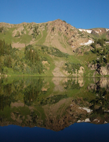
I took the appropriate turn and climbed towards Bowen Lake, nestled under a ridge in the south-western corner of the wilderness, nearly eight miles from the trailhead. I reached the lake at 1800, as it was threatening to rain, and located a suitable camp site in the woods east of the lake. I ate supper, set up camp, stashed my bear canister an appropriate distance from the tent, and retired for the night. I finished reading Crystal Soldier and discovered that the reason my LED lantern was getting dim was because it was running low on batteries. (Had I bothered to check the colored battery strength readout I could have figured this out before it gave out in the middle of the wilderness.) I did have a spare set of batteries, so an illumination catastrophe was averted.
Tuesday, 29 July 2008
Tuesday morning I ate breakfast, broke camp, and continued south past Bowen Lake to the saddle point and the wilderness boundary above the lake. I lost the trail at the south edge of the lake but managed to relocate it with a quick consultation with the topographic map on my GPS receiver. (If I haven't yet taken the opportunity to plug the fantastic maps from Above the Timber, let me do so now.) The saddle point gave me a great view of Longs Peak (its distinctive form silhouetted in the morning haze), the Indian Peaks, and a low cloud cover hanging over Grand Lake and Middle Park.
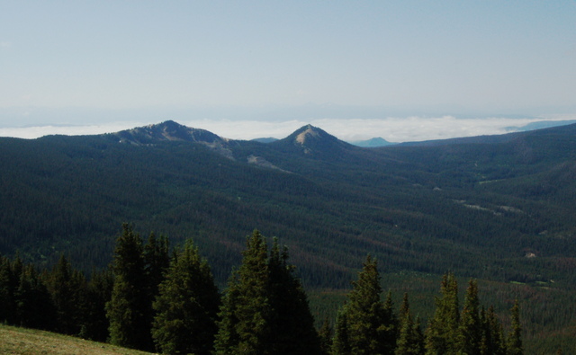
I followed the Continental Divide Trail north along the crest of the Never Summer Mountains until I lost the trail in the tundra. I picked my own path along the general course of the trail for a kilometer, which was somewhat sub-optimal in my full pack. I rejoined the trail before too long as the trail joined the Continental Divide itself and continued to follow the Divide north to Bowen Pass.
(It's worth pointing out a quirk of geography: the Continental Divide follows a meandering path through Colorado, dividing the water that flows into the Colorado River and the water that flows into the Mississippi River based on geology and glaciation history in a fairly arbitrary manner. As I was following the Divide north, the Divide had made a massive u-turn along the Never Summer Mountains: to the east lay the Colorado River destined for the Gulf of California, and to the west lay the North Platte River, destined for the Gulf of Mexico.)
I descended to the west of Bowen Pass and soon began climbing in a broad arc around Fairview Mountain before dropping across a saddle point on the Continental Divide below Parika Peak and above Parika Lake. I saw two people from several hundred meters away on Fairview Mountain and five or six people finishing at Parkia Lake from twenty meters away, but I managed to avoid actually interacting with any of them, keeping my wilderness solitude mostly intact.
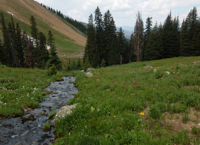
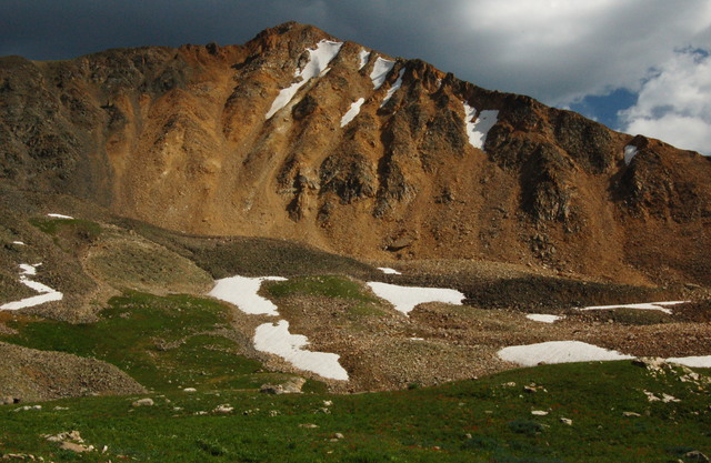
Below Parkia Lake, I continued north along the western edge of Baker Gulch with the full splendor of the Never Summer Mountains laid out before me. The trail proved difficult to follow in places, being overgrown by vigorous meadows. This proved tame to what I encountered when I crossed the Baker Pass (and the Continental Divide once again) and saw no trace whatsoever of the trail. I descended the broad meadow and soon caught glimpses of broadly-spaced cairns suggesting the general outline of where the trail might go. At timberline, I dropped my pack (careful to mark a waypoint) to scout possible campsites and ultimately found a small, durable surface that didn't look like it harbored any snags waiting to fall.
I set up camp, ate supper, stashed my food, and retired to my tent for the night. As I set up the tent, I wondered if this will be the last time I'll set up the tent this summer, or the last time I'll set up the tent in the backcountry this summer. I considered the Five Year Plan for procreating, set to expire next year, and wondered how soon I'll be able to go camping under that plan.
As I sat in my tent documenting last week's mountaineering adventure, I heard what I took to be a moose coming by: regular hooves hitting the ground and a loud exhaling of breath, not unlike a horse. If it noticed my camp at all it paid me no mind and walked off.
Wednesday, 30 July 2008
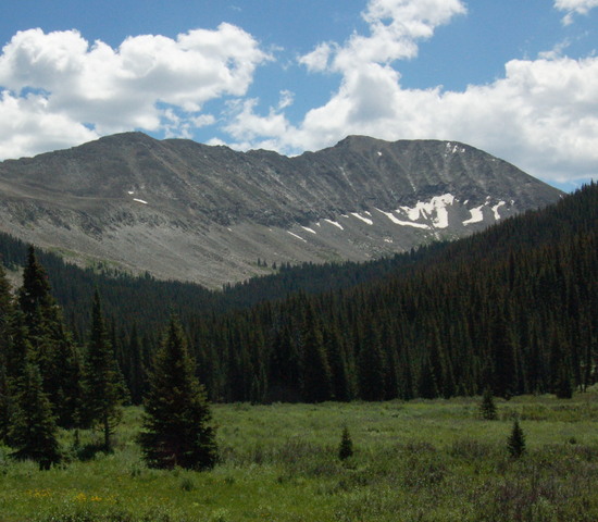
My plan for Wednesday was an out-and-back day hike along the Never Summer Trail. This proved easier said than done; the trail spent most of its time above timberline above the South Fork of the Michigan River, and where it crossed an alpine meadow it was almost impossible to locate, but for broadly-spaced cairns and (occasionally) trampled vegetation where someone (or some moose) had gone before. Where the trail passed through forested areas it was generally easy to follow, and where it crossed talus slopes a nice trail had been carved by carefully arranging the stones. My 24,000:1 topographic map printout and GPS receiver generally kept me going in the right direction, but I did completely loose the tread on the approach to the saddle point below Mount Cirrus and again once I descended into the Silver Creek drainage.
I left the Never Summer Wilderness into Routt National Forest and soon encountered the Silver Creek Trailhead at the end of a four-wheel-drive road. It was nearly 1300 and I didn't think I'd have enough time to achieve my goal for the day: summiting Mount Richthofen and Static Peak. I set at turn-around time of 1400 and headed into the woods along a different branch of Silver Creek, starting north-east and soon turning east. The Never Summer Trail was supposed to continue north from the Silver Creek Trailhead, but I couldn't find it on the ground. As I climbed along the stream, it appeared that a rockslide had moved the main channel of the stream to the south so that the trail no longer closely followed the main stream as my map indicated.
I continued upstream, far from the nearest designated trail, and soon found a series of game trails to follow. As I climbed, the valley narrowed and the game trails took on the appearance of a social trail, with far more distinct tread than much of the Never Summer Trail. I reentered Never Summer Wilderness and the valley opened up into a spacious alpine park. I was happy to declare the park as my new official destination, though my feeling of solitude was damaged when I spotted a spent tampon applicator and wrapper next to the rock I selected for lunch. I packed out the litter.

I began my descent at 1400, right on schedule. The trip down the mountain to the Silver Creek Trailhead was much easier than the climb up, and the trail up Silver Creek seemed almost as easy as the descent. I had two advantages finding the trail on the return trip: I knew where I had been before (and where I had gone wrong), and I was going in the opposite direction so everything looked different anyway.
I narrowly avoided encountering a campsite set up on top of the trail below Mount Cumulus. In bold defiance of Forest Service regulations mandating 100 feet of separation between the designated trails and campsites, the tent was pitched immediately adjacent to the cairn marking the trail. (I will concede that the tread was non-existent at that point, but it was still a designated trail.) I hadn't seen anyone all day and hadn't even seen any evidence of human visitation (the tampon applicator notwithstanding), and I didn't want to ruin my day of perfect solitude, so I cut into the trees below the trail and rejoined the trail a few hundred meters away.
Back at camp, after dark, I heard several moose visits but couldn't actually see anything.
