Mount Logan
Started: 2014-08-10 17:31:38
Submitted: 2014-08-10 21:05:45
Visibility: World-readable
In which the intrepid narrator climbs a mountain that was not actually named after him
Scattered throughout the American West are a variety of features bearing my family name. Most western states have a Logan County, and Utah has an entire city named Logan. At the moment I'm most interested in mountains in Colorado within day-trip distance of Boulder, so the 12,870 foot Mount Logan in the southern portion of Mount Evans Wilderness has been on my list for several years. (This is not the only Mount Logan; Summitpost.org lists six mountains named Logan, all in North America, named after a random assortment of nineteenth-century Logans whom I may or may not be related to. The highest and least-accessible is also the highest point in Canada. But the prospect of an accessible mountain with my name on it was too good a chance to pass up.)
I set out on Saturday morning, 2 August, to climb Mount Logan. The easiest route to the summit starts at the Threemile Trailhead on the south-west side of Mount Evans Wilderness, off the Guanella Pass Road. The trailhead is an almost-two-hour drive from Boulder up US 285. I reached the trailhead a little after 08:00 in the morning and saw that I was the third car in the parking lot.
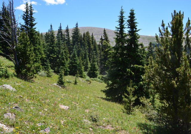
The trail followed a stream through a narrow, densely-wooded valley that turned to the east and began to open up after several miles. I caught my first glimpse of Mount Logan as the trail began to climb the adjacent hillside on its way to the pass to the north.
I left the trail four miles from the trailhead, as the terrain opened up closer to treeline, and began to head in the direction of the peak, contouring around the upper reaches of the valley through the clumps of trees and into some small patches of willows. These willows were rarely higher than knee-height, and I had no trouble finding a path between them. As I was negotiating a patch of willows I heard a greeting and looked up to see another climber coming down from Mount Logan. We were at least a half-mile from the trail, and more than a mile from the summit, and we happened to run into each other in the middle of the wilderness. He was the first person I'd talked to all day long.
I continued hiking in the general direction of Mount Logan, leaving the trees and willows behind, and soon found myself on a talus slope spotted with patches of thick tundra. The mountain curved away from me, so I could never see more than a few hundred meters of mountain ahead of me, which gave the illusion that I was constantly close to the top. I eventually reached the broad rounded top, mostly unremarkable but for a semicircular pile of rocks forming a crude wind barrier and the remains of a wooden tower, possibly left over from some mining expedition.

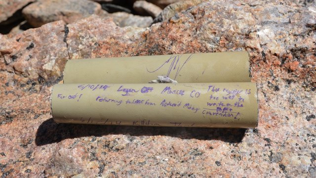
I located the summit register but found it drenched, thwarting my attempts at signing it.
To the south I could see the northern reaches of Lost Creek Wilderness on the other side of the South Platte River and US-285. To the east the mountains dropped off into the plains and civilization. To the north I could see cars driving up Mount Evans above the rolling tundra. To the west I could see more mountains than I could count (or recognize), in the edge of the Front Range and continuing into the Tenmile/Mosquito Range.

On my descent I swung further north, staying higher above the willows and scattered trees around treeline, eventually dropping down onto the trail right where I left it. From there all I had to do was walk the rest of the way to the trailhead, finishing off the twelve-mile round-trip hike. After my last big summit hike twelve miles seemed like a reasonable distance: far enough that I could feel like I accomplished something, but not so far that I returned to civilization completely exhausted.
