Chiefs Head Reprise
Started: 2015-08-13 21:47:51
Submitted: 2015-08-13 22:59:58
Visibility: World-readable
11 July 2015: In which the intrepid narrator snow-climbs the Chiefs Head-Pagoda couloir
Chiefs Head Peak marks the southern end of Glacier Gorge in my favorite local national park. Its summit is accessible from the north, via Glacier Gorge; or from the south, via Wild Basin. I first climbed the peak back in 2011, from the south via the peak's long tundra-covered ridge reaching towards Sandbeach Lake.

I don't often reclimb peaks I've already climbed, but the northern approach on Chiefs Head Peak offered an interesting alternative to the route I'd climbed before. After missing most of the snow-climbing season in June due to a variety of baby-related scheduling constraints, I decided to climb the couloir between Chiefs Head Peak and its neighbor, Pagoda Mountain, on Saturday morning, 11 July 2015.
I woke up alpine-early and arrived at the Glacier Gorge trailhead in Rocky Mountain National Park in the just-after-dawn light shortly before 06:00, in time to take one of the last parking spaces in the lot. I saw only a handful of other climbers in the parking lot, and by the time I hit the trail they had vanished.
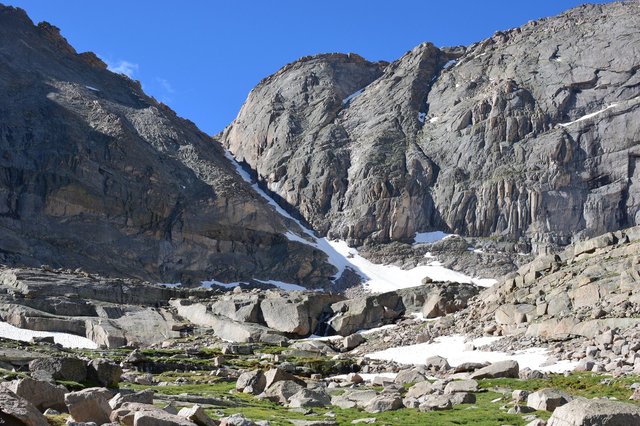
I took the climber's shortcut trail around the Glacier Knobs and continued south along the maintained trail, past Mills Lake, to Black Lake. From Mills Lake I could see the couloir I intended to climb, and I was pleased to see that the snow reached almost to the top, though I was concerned about the conditions of the couloir above the end of the snow. From Black Lake I could see McHenrys Peak towering photogenically above the lake, but my view of my destination was obscured by the cliffs to the south of the lake. I followed the gully to my left leading up to the large glacial basin nestled between the surrounding peaks. The basin was dotted with streams and ponds with grassy fields between boulders protecting willow thickets. In some places I could see the glacier-polished bedrock.

The basin also featured a confusing grid of cairns and the occasional social trail, which seemed to be laid out in a regular grid pattern rather than laying out any sort of reasonable trail system. I headed to the southern end of the basin, as the solid granite face of the Spearhead loomed to my right.

I reached the snowfield at the base of the north-facing couloir and paused to don my crampons and helmet and exchange poles for my ice axe. The snow was good: soft enough in the mid-morning sun to give me enough purchase with my crampons, but not so much that I'd run the risk of it sliding under me. The snowfield soon narrowed into the couloir, where a steep cliff loomed to my right and a more gentle rock slope climbed to my left.
It took me more than an hour to ascend the couloir. When the snow ran out I was about a hundred vertical feet from the saddle on wet scree that had until recently been covered by snow. I reached the saddle and saw Wild Basin and Indian Peaks laid out to the south, a nice change from the craggy peaks surrounding Glacier Gorge.
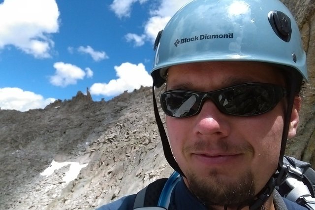
I turned my attention to the scramble that remained up the ridge of Chiefs Head Peak, which seemed to take longer than it had any right. I reached the summit shortly before noon and sent out a triumphant selfie from the summit.

To the east I could see Longs Peak, one of only two peaks in the immediate area higher than I was. From my vantage point I could see Keyhole Ridge in profile, and I had the unique experience of being able to look down through the Keyhole. Snow lingered on the ledges and in the trough, but I could see that people were making their way along the route.

I signed the soggy summit register, ate a snack, and began my descent to the west from my lofty perch. Instead of going back the way I came, I decided to form a lollypop loop by descending Stone Man Pass, which would take me back to the basin at the end of the gorge without having to descend the same couloir. The slope to the south quickly gave way to a cliff, and the ridge narrowed into a two-meter-wide band of rock, leaving me with an airy traverse as I triple-checked every footstep to make sure it was stable. Just as quickly as it shrank the ridge broadened again into a wide, boulder-strewn slope -- and I saw the first people I'd seen all day (except for a couple I passed near Mills Lake), a pair of climbers carrying ropes and other technical gear coming in the opposite direction. They'd started the day by climbing Arrowhead, at the opposite end of the basin, then traversed to McHenrys Peak, with the goal of traversing the rest of the basin (Chiefs Head, Pagoda, Keyboard of the Winds, Longs). I wished them luck and we continued in our respective directions.
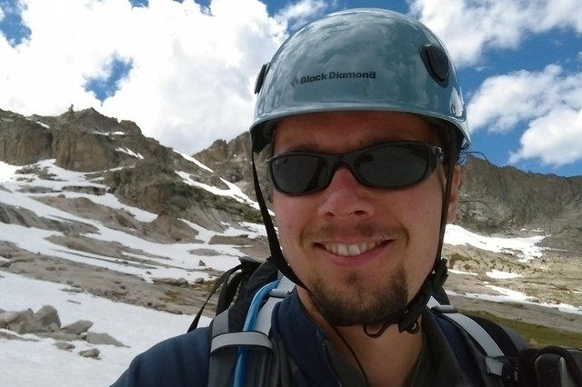
I found the direct route to Stone Man Pass blocked by cliffs, so I descended a modestly-trod gully, traversed a small snowfield, and picked my way back up the boulders to cross the pass. I took a selfie with the Stone Man on his eponymous pass, and wondered if that was the first time the words "selfie" and "eponymous" had been used together in a sentence.
I crossed Stone Man Pass and found a large snowfield waiting for me on the descent. I donned crampons and began my descent, but my attempts at plunge-stepping ended in my loosing footing and beginning to slide, in an echo of my first descent of this snow field while climbing McHenrys Peak. I quickly self-arrested, tried again, slipped again, self-arrested again, and changed my stance to down-climb the rest of the snow field facing inwards. This proved tiring, as I had to carefully kick steps in the snow for footholds, but was still better than climbing.
As the snowfield widened out I did a descending traverse to gentler terrain. When I ran out of snow I took off my crampons and traversed the basin to reach the gully on the other side, making my way across the granite bedrock strewn with boulders and snow that gave way to grassy slopes and more willow thickets.
By the time I reached the eastern portion of the basin the social trails had coalesced into something that I could actually follow reliably. I descended the gully to Black Lake and immediately began seeing people again. Once I was back on the trail I exchanged my climbing helmet for my LTE cap and began the long, uneventful trek back to the trailhead.
