Where the streets have no name
Started: 2017-02-20 16:49:52
Submitted: 2017-02-20 22:28:16
Visibility: World-readable
13 February 2017: In which the intrepid narrator visits the lowest basin in the entire western hemisphere
One advantage of camping in the winter was that the sun didn't actually rise until a reasonable time in the morning.

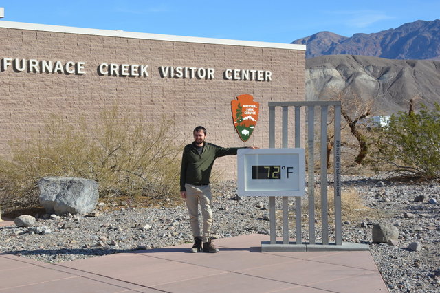
After breakfast, at Furnace Creek Campground, our first stop was the Furnace Creek Visitor's Center, at 190 feet below sea level, complete with a sign showing the current temperature as a photo opportunity (which, of course, we took). At 09:30 in the morning in the middle of February, the air temperature was a balmy 72 degrees, but it was easy to imagine how much hotter it could get in the summer. The visitor's center itself was small and had a few interesting artifacts from the human history of Death Valley.

Our next stop was further south in Death Valley: Devil's Golf Course, a bizarre collection of salt-encrusted mud formations spread out across the valley floor, named because some early visitor quipped that only the devil would want to play golf there. (This is in contrast to the actual real golf course at 190 feet below sea level in Furnace Creek, watered by a freshwater spring, where actual people would (presumably) want to play golf.) The salt had crystalized the mud into solid shin-high blocks, with sharp cutting edges (and signs warning tourists to be careful). I walked between the blocks, trying to wrap my mind around how different the formations were from anything I'd ever seen before. The blocks seemed to have organized themselves into foot-wide sections, on an approximately hexagonal grid (which I attributed to the natural effect of sphere packing -- when the mud dried out it shrunk and cracked evenly).

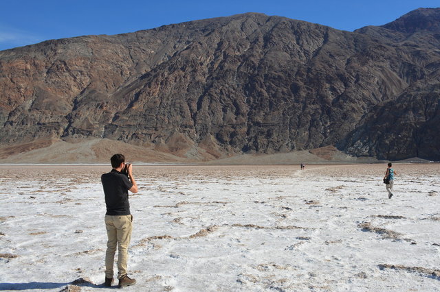
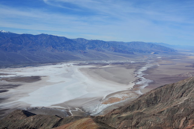
Next on the list was Badwater Basin itself. At 282 feet below sea level, it's the lowest point on dry land in all of the western hemisphere. (An interpretive sign at the parking lot had a handy list of all of the below-sea-level basins, including one in Xinjiang at more than 500 feet below sea level that I'm now interested in visiting.) A sign on the cliff behind the parking lot marked sea level, well above ground level. Knowing that we were hundreds of feet below sea level was weird, but not nearly as weird as the otherworldly scenery around us.
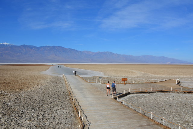
Badwater Basin had a boardwalk leading from the parking lot over a mud flat, next to a small spring-fed pond that an interpretive sign assured us was present year-round but very salty. I saw pickleweed growing next to the pond, the only living plant for what seemed like miles in any direction. (I've seen pickleweed in the salt marshes around San Francisco Bay; it disposes of excess salt in leaves that it discards.) The boardwalk gave way to a dry salt flat, which had been worn flat by tourists' feet over the years and now had a slightly spongy texture as the salt and dirt were compacted together.
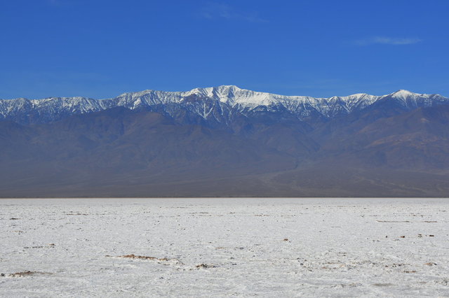
We walked out on the bottom of the basin until it gave way to a proper salt flat, a giant, almost-perfectly-flat expanse of brilliantly white salt stretching out for miles on the bottom of the valley, with the Panamint Range and the snow-capped Telescope Peak towering above the valley to the west.
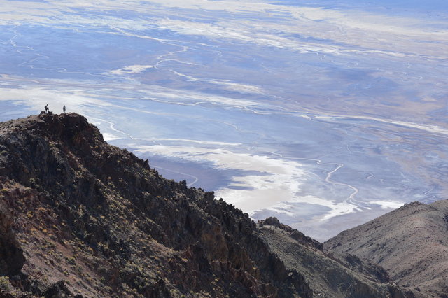
We left Badwater Basin and drove through the "20 mule team canyon", where borax mule teams were allegedly driven, to Dantes View, an overlook a mile above the valley floor where we could presumably see all nine circles of hell. Willy thought that U2 had shot the cover of The Joshua Tree here, so I pulled up the cover on my iPod, squinted at it on the tiny screen, and staged a selfie replicating the iconic cover.

From Dantes View we had a commanding view of all of Death Valley, centered on the salt flats at Badwater basin. I was fascinated by the different colors of dirt and mud at the bottom of the valley, and wondered what geological forces had created the colors and distributed them into their current locations.
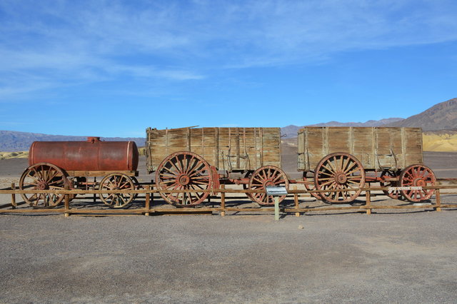
Our next stop was the ranger-led tour at Harmony Borax Works at 14:30. Borax, we learned, is a salt compound of sodium, boron, and oxygen that can be used as a household cleaner and laundry detergent. It was discovered in Death Valley in the 1880s and commercially mined in various stages until the 1920s (when competing mines in less-inhospitable places became commercially viable; the chemical companies promoted tourism in Death Valley as a way to recoup their investments, leading eventually to the creation of Death Valley National Monument in the 1930s). To reduce transportation costs, the mining companies collected naturally-occurring borax on the salt flats, processed it to remove impurities, and shipped it out over land to the nearest railhead. Among the problems they had, though, was keeping the process cool enough; they shut down for several months during the summer. (On the bright side, at least evaporative cooling works great in 11% humidity, when one has a good source of water like the spring at Furnace Creek.)
(While packing to move houses last month, I found Kiesa's box of 20 Mule Team Borax; she tells me she uses it as a laundry booster and abrasive cleaner.)
The ranger who gave the talk had been at Death Valley for a couple of years and knew one of Willy's friends from graduate school, who served as a ranger in Death Valley a couple of years ago.
We dropped by the campground to actually register for the site, then headed to Furnace Creek Ranch to look at the borax museum. It was supposed to be open until 18:00, but the tiny one-room building (which, through the window, looked to be at least half kitchy gift-shop) was closed for "lunch". We wandered around the building and found a large yard immediately behind it filled with industrial equipment from Death Valley in the late nineteenth and early twentieth centuries, almost perfectly preserved in the desert air. Not all of it was very well described, but most of it had at least a small label indicating what it was or where it had been used. I was especially interested in the steam traction engine that replaced the mule trains for carrying borax out of Death Valley to the nearest railhead.
Willy found a recently-purchased annual pass to the national parks under a rail car as we were studying it, so we dropped back by the visitor's center to give it to the rangers there in hopes they would be able to figure out what to do with it. I studied the maps and decided to make one more trip for the day: to Salt Creek, a little spring-fed saltwater stream around sea level that holds its very own species of little fish. The sun set as we walked along the boardwalk looking at the fish in the stream.

By the time we got back to camp, it was dark and I was feeling badly dehydrated, having spent all day in the sun (and low humidity) without enough water. I managed to cook supper ("rehydrate" is probably a better word) but didn't immediately feel well enough to eat it on my own before I managed to rehydrate myself. I resolved to pay more attention to my own hydration on the next day.
