Megaproject
Started: 2019-02-16 15:27:40
Submitted: 2019-02-16 23:44:18
Visibility: World-readable
2 February 2019: It's a viaduct party! A big viaduct party!
Seventy years ago, as freeways were being built all across America, Seattle embarked on a project to build a double-decked highway viaduct right in front of its waterfront, cutting the waterfront off from downtown. The Alaskan Way Viaduct (or just "The Viaduct", always with the definite article, always with the definite article capitalized, because there were many viaducts, but there was only one The Viaduct) was damaged during the 2001 Nisqually earthquake, and structural analysis suggested it was vulnerable to a total collapse (a point illustrated in this dramatic video, a video which I'm glad I only found after the viaduct closed).
When I lived in Ballard Washington state highway 99 was the best way to get to the airport. The highway ran across the viaduct in its middle section past downtown, then continued at surface level through industrial southern Seattle, eventually swinging by the airport. (The airport was a half-hour drive in good traffic conditions; I was lucky enough to not need to go to the airport during poor traffic conditions.) Southbound traffic traveled on the lower deck of the viaduct, but the best view was reserved for northbound traffic on the upper deck, with an expansive view of Elliott Bay, the Washington State ferry terminal, and the buildings of downtown Seattle (at least, when the weather cooperated).
After the 2001 Nisqually earthquake, the Washington State Department of Transportation embarked on a project to replace the viaduct with a structure that could actually withstand the sorts of catastrophic earthquakes that Seattle only recently discovered that it could have. This project went through multiple incarnations, eventually turning into a megaproject to bore a bypass tunnel under downtown Seattle, using the largest-diameter tunnel boring machine ever built; and because it was a megaproject, it ended up over-budget and years late.
Once the tunnel was finally ready, WSDOT* decided to close the highway entirely for three weeks while they demolished old ramps to the old viaduct and built new ramps to connect to the new tunnel. Local media predicted "Viadoom" as the 90,000 cars that took the viaduct daily spilled out onto local streets and clogged an already-over-capacity I-5. (Fortunately for me, the one time I tried to get to the airport during Viadoom was on a Saturday morning with light traffic.) But Viadoom mostly fizzled: faced with the prospect of heavy traffic people mostly changed their habits and drove at different times or chose not to drive at all.
[* In some of their videos, I'm pretty sure I heard "WSDOT" pronounced like "wash-dot", so I'm relieved to know that I can abbreviate something in Washington as "wash". This is somewhat less awkward than my proposed pronunciation, "wuss-dot".]
After three weeks of closure, WSDOT scheduled a party to open the tunnel and bid farewell to the viaduct. (I marked it on my calendar as a "celebration of life" for the old viaduct.) I signed up for the Tunnel to Viaduct 8k Run, with the tagline "Run like the viaduct is collapsing behind you! (Note: it won't!)", which promised the first access to both the tunnel and the viaduct.
I woke up early on Saturday morning, 2 February, and walked a few blocks north to the bus stop serving route 26, which looked like the best way to get to race's starting line, at the north portal of the tunnel next to Seattle Center. It was not raining, but the ground was wet from the last rain, and the sky was overcast. As I waited in the pre-dawn gloom, three other runners arrived at the bus stop. The bus arrived late, standing-room-only with runners and walkers heading for the starting line, and we stopped to pick up more people as the bus headed through Wallingford and onto SR-99.
Before we reached Seattle Center, the bus got caught up in the viaduct closure and rerouted onto small neighborhood streets in Lower Queen Anne before making its way onto Mercer St and letting us off there, a few blocks from the tunnel portal. I made my way to starting corral 2, seeding myself in the general vicinity of runners in the 8-minute-mile range.

The sky remained gray and I felt a few sprinkles of rain. The air was cool, not cold; and I felt comfortable waiting for the race to start in my high-visibility running vest (which, I realize, ten years after I bought it, now represents Wallingford because the company Brooks has its headquarters in a new modernist building on Wallingford's corner with Fremont).
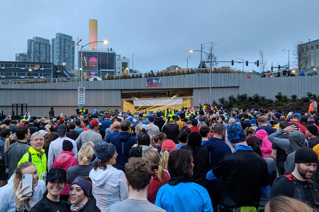
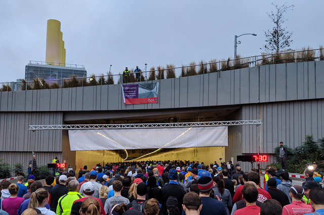
At length we made our way to the starting line, then waited for the tunnel to clear from the first starting corral. At last our corral started, and we shuffled then walked then ran to the starting line, placed immediately at the tunnel's north portal.
We ran on the southbound traffic lane, forming the upper deck of the double-decked tunnel. Above us I could see the outlines of the precast concrete segments making up the tunnel, covered in fireproofing.

As I ran, keeping pace with the crowd around me, I took note of the safety features visible in the tunnel around me. Everything seemed designed with the lessons learned from the Caldecott Tunnel fire: there was a wide hard shoulder at the right, providing an ample breakdown lane; there were fire sprinklers providing multiple independent fire-suppression zones; there were clearly-marked escape exits every 650 feet, leading to positive-pressure spaces of refuge and a walk out either side of the tunnel; and there was a negative-pressure exhaust on the other side of the tunnel, with automatically-operated louvers currently closed, capable of drawing smoke away from any fire in the tunnel. The grade of the tunnel formed a giant "U": we descended for the first half of the run (at its lowest point, the crown of the tunnel is 95 feet below sea level), then ascended a gentle grade to the south portal. The grade of the tunnel kept it from forming a chimney in the event of a fire, though I presume they would have to install a pump to evacuate the sump at the bottom of the tunnel.

We ran out of the south portal of the tunnel, then took the first off-ramp to the left and turned back north to run through SoDo. I could see where part of the viaduct had been demolished already, leaving on-ramps going nowhere. I touched one of the concrete abutments leading up to the on-ramp and someone behind me asked, "One last time?"

The route took us up an off-ramp onto the south-bound lower deck of the Alaskan Way Viaduct, then ran northwards along Elliott Bay. As I merged onto the viaduct I reached out and patted one of the support columns as I passed, trying to use physical contact to anchor the memory of the derelict viaduct during my celebration of its life.
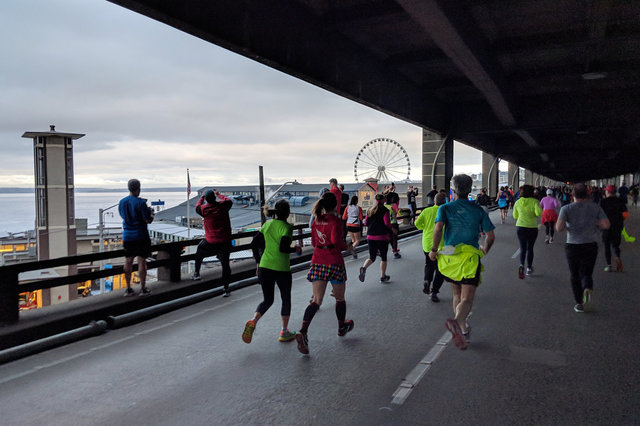
Low clouds hung over Elliott Bay and the Puget Sound, obscuring the view of the Olympic Mountains. We ran on the lower deck, obscuring our view of downtown Seattle but framing the view of the waterfront. Some runners stopped to take pictures of the waterfront; I ran along but pulled out my phone to hurriedly grab pictures as I ran (as I did for all of the pictures here).

The route continued through the Battery Street Tunnel, looking even more post-apocalyptic now in its end-of-life than it had during its service lifetime. We emerged into open air under cloudy skies next to Seattle Center, a block from our starting point at the new tunnel's north portal, and wound around the streets to finish under the monorail next to the Museum of Pop Culture in front of the Space Needle -- covering three iconic Seattle images in one. (Four, if one considers that it was almost raining at the time.)
I finished the 8k race in 44:13, for an average pace of 8:54. This was an ok but not a great finish, but entirely respectable given how little I've been running lately. (My base aerobic pace is about 9 minutes per mile; with minimal effort I can run at that pace indefinitely.)

I grabbed snacks in the post-race recovery area, in a plaza in front of the Museum of Pop Culture, then tried to figure out how to get back to Wallingford in time to pick up my on-call pager at 11:00. I walked out of Seattle Center, past crowds of people still waiting their turn to walk through the tunnel. The clouds briefly considered raining as I left the finish line, then thought better of it and stayed overcast for the rest of the day. With the tunnel-related closure, bus routes were confused, and Google Maps didn't know where the buses were actually going to be. I stopped for coffee in Westlake, then tried to catch a bus back to Wallingford. The buses didn't come on schedule, so I ended up walking back to my house in Wallingford.
And then I turned around and went back to Seattle Center to walk through the tunnel again, this time with my family.
For more pictures of the unnamed SR-99 tunnel, see Photos on 2019-02-02.
