Bolder Boulder 2019
Started: 2019-07-01 21:36:01
Submitted: 2019-07-02 00:55:11
Visibility: World-readable
In which the intrepid narrator climbs Green Mountain, runs the Bolder Boulder, drives into the clouds obscuring the mountains, and drives by his old house
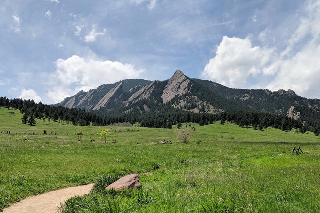
On Sunday, 26 May, I had one day free to explore the mountains around Boulder. I had wanted to drive to Rocky Mountain National Park and drive across Trail Ridge Road, which is often open in time for Memorial Day weekend, but late snow this year (the same snow that I observed from the air) kept the road closed. Instead I drove to Chautauqua, parked along Baseline Road, and hiked along the meadow, past the Flatirons, and up Gregory Canyon to the Ranger trail leading to the summit.
It was a route I'd hiked many times before, in all weather conditions. The sky started partly cloudy, then the clouds increased as I climbed. I could feel the thin mountain air, the result of living at sea level for three years, but I made it to the top only slightly tired.
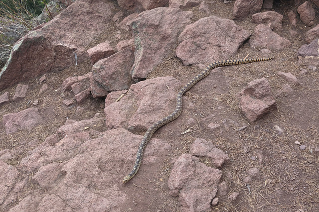
I picked my way through the crowd of people at the summit rock and tagged the peak finder, then descended to the rocks overlooking the City of Boulder and the plains to the east. I heard someone shouting, clearly agitated, and found that they were fleeing a large snake (at least four feet long, about three inches in diameter). I tried to assure them that it wasn't a rattlesnake and was probably harmless. They let the snake slither away and I watched, intrigued, and stepped close enough to get a picture before it disappeared into the rocks. (From posting the picture on Twitter I learned it was probably a bullsnake, which is not poisonous, and generally avoids humans, but will bite if cornered; and then you have a puncture wound in your hand that you should go get cleaned out so it doesn't get infected.)
As I began my descent, tracking a loop down the EM Greenman trail, I looked to the snow-covered Continental Divide to the west, where I could barely make out the outlines of the mountains I knew and loved (and climbed) when I lived in Boulder: James Peak, Arapahoe, Navajo, Shoshoni, Paiute, Audubon, Notabon, Ogalalla, and Elk Tooth.

I descended the EM Greenman trail to the Saddle Rock trail, then returned to my car after my hike. I stopped for a late lunch at Snarf's, which still makes the world's finest sandwiches (despite my best efforts to find anywhere else that will make sandwiches nearly as good).
In the evening I ate at Black Pepper Pho, down the street from my hotel, then went to bed early ahead of the Bolder Boulder the next morning.
Memorial Day
For years, the Bolder Boulder has required proof of a qualifying time in order to get into a wave start with an estimated finish time of less than 70 minutes. (It's a ten-kilometer race, so that's anything faster than an 11-minute mile, or what most people would consider "jogging". Note that I do not "jog", since that's the diminutive form of running; instead I "run at an aerobic pace".) When I lived in Boulder I had ample opportunity to find a qualifying race, including races explicitly set up as qualifying races where I'd get a timing card at the finish line then take that to the registration table to enter into the appropriate wave.
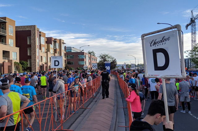
This year I didn't find a race I wanted to run in as a qualifier -- my spring was busy enough that I barely had a free weekend in April and no free weekends at all in May. I thought I might have to show up to run on a treadmill to qualify when I found the 2019 BOLDERBoulder 10k Qualifier on running platform Strava. All I had to do was run at least five kilometers (using my existing Garmin Forerunner 620 running watch), upload the track to the Garmin app on my phone, which would upload it to the Strava app on my phone, which would upload it to Strava, which would find my best 5k time in there and figure out my qualifying time. I ran along a flat section of the Burke-Gillman Trail and qualified into the "D" wave, with a net pace of around 8 minutes/mile, for an estimated finish time of 51:20.
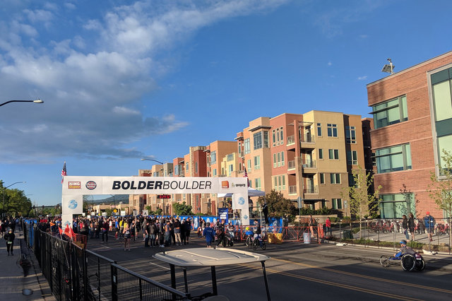
My alarm woke me up at 06:00 MDT on the morning of Memorial Day, which gave me plenty of time to walk around the corner from my hotel to the starting line at 30th and Pearl, and find my wave start. The morning was clear and cool; runners sorted themselves into waves by the letters on their bib tags, with the fast serious runners lining up in the "A" wave. I stood on the corner of Walnut and 30th, normally busy with traffic but this morning taken over by runners preparing for the race.
The race started at 06:55 with the "push rim" race, which the announcers kept having to clarify meant "wheelchair". The runners started next, in groups of a few hundred people to give a better starting experience, and spread out the stream of people running through the streets of Boulder. I joined my wave as it shuffled to the starting line; then, at 07:05, our wave started and we were off.
I let the crowd carry me across the starting line and into the race, but soon I realized that they were running faster than I could sustain for six miles, so I began to fall back to a more-comfortable aerobic pace. (I did some speed training this spring, but not enough to carry me through a six-mile race -- certainly not at altitude, where I lacked the red blood cells to carry enough oxygen in the thinner atmosphere.
I settled into a sustainable pace and enjoyed the race as it wound through the streets of Boulder early on the holiday morning, past bands setting up in parking lots and an Elvis impersonator and belly dancers. People sat in lawn chairs on the sidewalks and on their lawns to watch the race go by and cheer the runners as they passed. I watched the miles tick slowly past on the course I knew well -- running up and down the hill on Folsom, then looping lazily through the neighborhoods in North Boulder and climbing the hill on 13th to the race's highest point, 5380 feet above sea level, at Casey Middle School, right at the four-mile mark. This was my signal to pick up the pace as the route took me past downtown and onto Pearl Street, then onto Folsom again for the last mile into Folsom Field. The bagpipers were right where I saw them the last time I ran the Bolder Boulder; I ran past them, across Boulder Creek, up the hill, onto the access road leading to the stadium, finally turning the corner and seeing inside the stadium for the first time (still mostly empty, that early in the race, with most of the runners behind me), running onto the field (half of it in shade, half of it in bright morning sun), sprinting around the plastic deck placed onto the field, making the gentle U turn at the south end of the stadium and running as hard as I could across the finish line. I finished in 54:53, a respectable time.
I crossed the bridge leading to the east stands, then picked up my "lunch" and returned to the stadium to eat and watch the race. I saw a pair of people dressed in Pikachu costumes cross the finish line, and again I wondered if I was passing up the full race experience by not running in costume.

Before long clouds rolled in and I got cold; I bid the stadium farewell and walked back to my hotel, past the people still running the race on Folsom. I walked past the starting line a few minutes after the last wave of walkers departed; then the army of race workers began to dismantle the starting line so the road could return to its regularly-scheduled automobile traffic.
I showered, packed, and checked out of my hotel; then ate a late breakfast at Moe's Bagels on 28th (just outside of the race closures). My flight back to Seattle didn't depart until the evening, so I had some time to find one last thing to do in northern Colorado before I left. I'd seen what I wanted to see in Boulder, so I drove north on US 36 into Lyons, then turned up CO 7 towards Estes Park. As I drove up the canyons I knew so well the clouds descended, thwarting my view of the mountains I had come to see. I stopped at Lilly Lake, where a storm was rolling in; I returned to my car just in time for it to start hailing, covering the road in enough pea-sized hail that it looked like snow.
I drove around Estes Park without stopping, then drove down US 36 back to Lyons, then continued into Longmont and stopped at the Starbucks at 17th and Pace where I used to visit when I lived in Longmont (from 2004 to 2012). The strip mall Starbucks was still there, as was the pizza place and King Soopers; but across the street Safeway had closed sometime in the seven years since I last visited.
On my way out of Longmont I drove by my old house. I hadn't been back since I moved to Boulder seven years ago, and the house looked much the same as it did when I left. The lilacs I planted in the side yard had grown and were now towering shrubs. Some of the problematic loose rocks over landscaping paper, which formed an unsteady border between the lawn and the side of the house, had been replaced by flagstones (which seemed to be a good idea). The shrub roses I planted in the front planter bed were gone; it wasn't immediately obvious what had replaced them.
I drove back to DIA and caught my flight back to Seattle. After five days in Boulder I'd seen what I wanted to see, to remind myself of the place I once called home for 25 years, as I wondered whether there was a place for Boulder in my future, if I'm willing to leave the big city behind and return to the small city nestled between the mountains and reality.