Holy Cross
Started: 2012-08-28 08:00:57
Submitted: 2012-08-28 20:53:14
Visibility: World-readable
In which the intrepid narrator climbs a classic Sawatch fourteener
Now that we've moved to Boulder, and put Calvin in preschool, he's on a schedule that more closely resembles a real school schedule, with a "summer" schedule and a "school year" schedule. The only substantive difference between the "summer" and "school year" was the one-week break between the terms in which the teachers did whatever they need to do to prepare.
This meant Calvin was without child care for a week in the middle of August. Kiesa's mother was interested in coming out to visit sometime in August, so Kiesa suggested she come to provide backup child care. I looked at my calendar and thought I might want to take advantage of Kiesa's mother's presence to visit some mountains that might otherwise be out of reach in a day-trip from Boulder. I was looking at a couple of Sawatch fourteeners with classic routes when Kiesa suggested that she'd like to get away as well, probably on some sort of low-cost camping expedition. I looked at options to retool the expedition and came up with a hybrid idea: I'd go climb a mountain, and Kiesa would hang out at camp and read. I decided to take my floating holiday as Colorado Fourteener Day (since I'm not going to make it out to the Pacific Northwest to celebrate Cascade Volcano Day this year) so we'd have a better chance at getting a non-reservable campsite at the trailhead.
While climbing Mount Bierstadt and Mount Evans last month, I realized that there was no way I could actually adjust the waist and shoulder straps on my 50-liter Kelty daypack so that the waist straps transferred the weight to my hips. While hiking (and scrambling, and suffering from hypoxia) I wondered about the length of my torso and whether I ought to acquire a different pack that actually fit me. After returning home, I researched and learned about the official way to measure one's torso (from the C7 vertebra at the base of one's neck to the ilac crest on one's hip) and measured my torso at 22 or 22.5 inches. The current version of my Kelty pack was rated only up to torsos of 21 inches, and sufficiently-large packs were difficult to find. (I was extremely disappointed that REI's website's parametric search did not allow me to specify my torso size to limit the search space.)
About this time Kiesa discovered the Pearl Street retail outlet of Gunbarrel-based sports gear company Golite, and raved about their low prices on clearance and seconded merchandise. I looked at their website and saw that the Quest line, though officially intended for overnight backpacking, included a 50-liter pack with an adjustable torso that was rated up to 22.5 inches. (Based on my hip measurement, I actually fit the medium pack, rather than the large pack, since both covered the same torso size.) I visited the retail store one day during lunch and found that the 50-liter Quest fit me perfectly. (One of the employees helped me fit the pack and loaded it lightly with 15 pounds of weight; he noted that no pack really felt good once one loaded it with 50 to 60 pounds of gear.) I bought the pack with two days to go before our camping expedition.
I left work a little early on Thursday, 16 August to finish packing the car and drive for three hours (down CO-93 to Golden to bypass Denver's rush-hour traffic, up I-70 through Summit County, across Vail pass, past Vail, through Minturn) to Halfmoon Campground at the end of Tigiwon Road. The road was closed all last year for hazard tree mitigation (cutting down trees killed by pine bark beetles), and there were large swaths of forest cut down and stacked in giant slash piles. We arrived at dusk with just enough light left to pitch our tent before darkness set in. Of the seven campsites, two were available; I picked the one with the somewhat-flatter tent site.
I forgot my pillow and slept fitfully; I dreamt about missing my alarm and of hearing someone else's alarm, the U2 song "Where the streets have no name". My alarm woke me up at 04:00; I ate breakfast (granola) in the car in the dark and headed up the trail at 04:45.
Instead of the standard route up Mount of the Holy Cross, I decided to undertake the "classic" Halo Ridge traverse, which looped all the way around the ridgeline, taking in two ranked thirteeners along the way. This was a fifteen-mile trek, with five thousand vertical feet, much of it off-trail class 2 scampering above thirteen thousand feet. After suffering from altitude sickness on Mount Evans I might have thought better of this, but I brought plenty of water and energy drinks and resolved to stop every hour to eat an energy bar.
I covered the two-and-a-half miles from the trailhead to my first waypoint, the junction with the trail leading to the Notch Mountain Shelter, in an hour in the dark, with only my headlamp illuminating the trail in front of me. It was beginning to get light as I stopped for a snack. As I ate, some movement caught my eye and I looked to see an owl gliding through the forest, fifteen feet above the ground, wings outstretched, completely silent. I watched, transfixed, as it flew over me and disappeared into the forest.
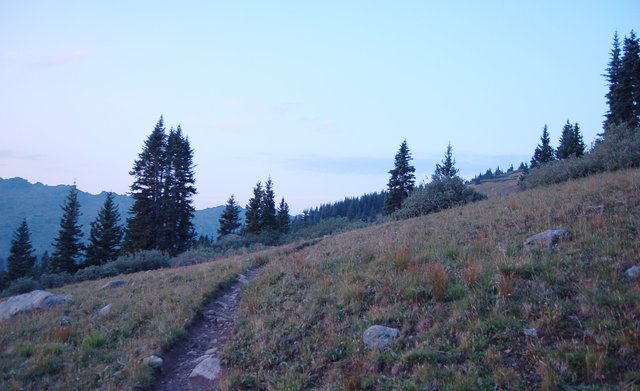
I followed the trail up the side of the mountain as it gained several thousand feet in another two-and-a-half miles. The trail climbed the outer edge of the ridge circling the cirque at the base of Mount of the Holy Cross. (If this formation were in the Himalaya, it would probably be called a sanctuary.)
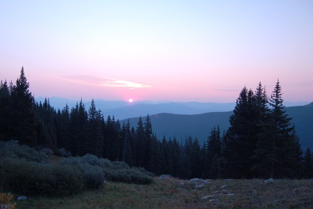
At the top of the ridge, I got my first good view of the east face, though the Cross Couloir was completely melted. The air was filled with a smoky haze from a large wildfire near Mount Shasta in California (giving me a physical connection to a Cascade volcano after all), and I could smell smoke above 13,000 feet. The mountain gets its name from a probably-retouched nineteenth-century photo showing a cross formed by a large couloir up the east face and a snow-covered ledge three-quarters of the way up the mountain. The cross inspired pilgrimages to the overlook on the ridge opposite the mountain and inspired the Forest Service to build a shelter on the ridge.
I ate half of a bagel overlooking the sanctuary and set my sights on the first mountain on the ridge, the ranked (but unnamed) Point 13,248, hopping over the boulders littering the ridge. I reached the point easily and continued along the ridge. As I crossed the low point on the ridge, I spotted a party ahead of me on the ridge, picking their way up the unranked Point 13,373. I reached the slope myself (as my podcast playlist switched from This American Life to Podcastle); this was the steepest and hardest part of the climb, picking my way carefully through loose dirt perched precariously among microwave-sized rocks.
I barely stopped at the top of the unranked and unnamed point; I was about seven miles into my fifteen-mile hike and was focused on putting one foot in front of the other. (The haze made the views less-than-spectacular anyway, and there was no snow anywhere.) I crossed a gentle grassy catwalk, which narrowed at one point with steep drops on either side, and stopped to rest on the saddle before attacking the next point on the ridge. I began to feel the effects of altitude sickness (no doubt not helped by the wildfire smoke) and broke out my food reserves: the sports drink Accelerade and caffeinated energy chews. This helped, and though I was not sure about my physical ability to cover the remaining eight miles of the hike I didn't think I wanted to turn around and try to retrace my steps; the only way out was through. (I saw a series of gentle lakes in the valley to the south, on the other side of the ridge from the Holy Cross sanctuary; I knew there was a trail leading to some of the lakes, which would take me back to the trailhead I left from, but I didn't know whether I could get there. While reviewing my guidebooks after the fact, I discovered that there was a class-two route down the ridge to the lakes.)
I pressed forward, following the ridge as it circled back to the west and climbed Point 13,831, the penultimate mountain on my route and the summit of Holy Cross Ridge, itself a ranked thirteener. I slogged my way to the summit and could, at length, see the final talus-covered slope leading up to the summit of Mount of the Holy Cross. I saw the cable tether for a missing Colorado Mountain Club summit register and turned to the final summit. I descended 300 feet and climbed 500 feet. I finally reached the summit around 12:30, nearly eight hours after I left my campsite. I was the highest point for miles in any direction, and I had a commanding view of Holy Cross Wilderness, including the ridge I traversed, and the deep valley to the west, but the wildfire haze dulled the scenery, and I didn't feel compelled to take any pictures.
I had the summit to myself when I reached the top. Just as I was about to leave another climber arrived from the standard north ridge route; I took a picture of him but it didn't make it into his trip report. (I might be the "lone hiker" in the picture near the summit; it's hard to tell.) I started my descent, picking my way carefully around the talus at the summit, trying to find a good line in the rough rocks. I was beginning to get worried about the time; I told Kiesa I would be overdue if I didn't return by 17:00, twelve hours after I left this morning, and I had used up two-thirds of my time with two-thirds of the distance covered, and I wasn't sure if I still had one-third of my energy left. I had about six miles left to hike, mostly downhill, but I had to climb a thousand vertical feet out of the Holy Cross sanctuary to get back to the trailhead, and I wasn't looking forward to that.
I descended the standard north ridge route, making a giant circuit around the sanctuary, and I was at a slight disadvantage from not having climbed that way, but I managed to follow the ridgeline and avoid the tempting social trails that led, off-route, straight down the mountain to the cliffs above the valley far below. (I loaded waypoints into my GPS receiver to help me navigate, but I'd studied the route well enough and knew what to look out for that I didn't really need my waypoints.) Halfway down the ridge I found a Colorado Fourteeners Initiative trail crew building a trail out of the talus, which improved my progress significantly. I thanked them for the trail and continued downward. On my descent I passed the pair of climbers that I had seen on Halo Ridge ahead of me; they had spent the night at the Notch Mountain Shelter and were impressed that I had come the whole way in one day.
I hit treeline but remained worried about the climb out the other side of the valley. As I descended, the valley grew more lush; I could see trees and waterfalls, and I knew there were a number of lakes up the valley. The valley looked inviting and worthy of exploration, but I was tired and worried about my deadline, so I pressed on. I crossed the creek at the bottom of the valley, stopped to fortify myself for the ascent to Halfmoon Pass with my remaining Gatorade, and began to climb. The trail was steep but steady, and just as the trees started to thin near treeline at the top the trail crossed the pass and began to descend the other side. I saw several groups of backpackers who were hiking into the valley to establish a high camp before climbing the mountain the next day and wished them well.
I returned to camp at 16:15, well within my deadline, tired but happy to be able to stop and rest. I'd hiked nearly fifteen miles, much of it off-trail class-two scampering over rocks of various sizes, and climbed 5400 vertical feet in 11.5 hours, with only a mild case of altitude sickness. I could check off one more classic summit route after a great (if long) day in the wilderness.
