White Rabbit
Started: 2009-08-17 20:35:17
Submitted: 2009-08-17 21:23:49
Visibility: World-readable
My alarm woke me up at 05:30 on Saturday morning, 8 August 2009. I ate breakfast, drove up the South Saint Vrain Canyon, and reached the Wild Basin entrance station on the south-east side of Rocky Mountain National Park a little after 07:00, which turned out to be too early for the station to be staffed; a sign requested that I pay upon departing. I parked at the trailhead at the end of the road, coerced my GPS receiver into acquiring my position, and headed up the trail.
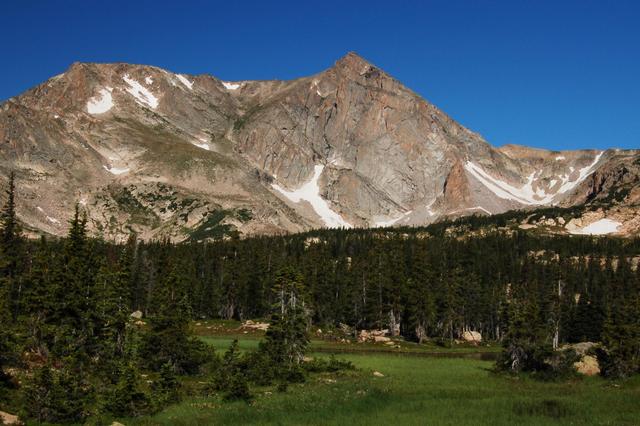
I took the shortcut trail on the north side of the North Saint Vrain Creek, thwarting my views of my destination but cutting a kilometer off my hike. I turned off the Thunder Lake Trail and headed up the Lion Lakes Trail, up the hillside on the trail that eluded me in April while covered under feet of snow. (I barely recognized the terrain from my snowshoe expedition; the map on my GPS receiver kept me basically on-route back in April but that still wasn't enough to identify the trail from the ground.) I caught occasional glimpses of Mount Alice through the trees but didn't get my first good look at the sharp east face until the trail entered a meadow just below Lion Lake No. 1 -- and Alice jumped out from the trees in all her glory.
I followed the trail a few hundred meters to the first Lion Lake and had a bit of a surprise when I stepped off the trail; my left knee faltered and almost gave way, refusing to support my weight on anything other than flat surfaces. I attributed this to the runner's knee I recently developed on my way to running a half-marathon and stretched a bit. My knee quickly got used to the idea of actually climbing and didn't bother me for the rest of the hike.
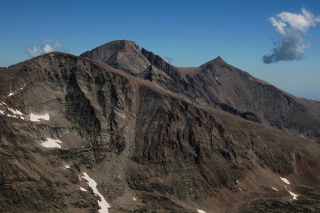
The maintained trail gave up around Lion Lake No. 1 and I followed a faint user trail past Trio Falls and Lion Lake No. 2 to Snowbank Lake. I pumped water from the lake to refill my water bottles and hydration bladder and headed up the ridge to the west, climbing out of the basin formed by Chiefs Head Peak to the north. Once I found the crest of the ridge the route-finding became easier; I didn't have as much trouble figuring out where I was supposed to be going. I got a close-up look at Mount Alice's east face and a better look at my intended route, Hourglass Ridge and the north slope. My guidebooks all insisted the route was non-technical but did mention exposure, and I could see plenty of exposure from where I stood.

I reached the saddle between Mount Alice and Chiefs Head Peak and studied my surroundings and the route. To the north I could see McHenrys Peak, McHenrys Notch, and Powells Peak at the south end of Glacier Gorge. To the east I could see the very top of Longs Peak poking above Chiefs Head Peak. To the south was Hourglass Ridge and Mount Alice, looking both dangerous and inviting.

I turned south along the Continental Divide, crossed Hourglass Ridge with a few simple moves, and headed up the steep, exposed north slope of Mount Alice. I pulled my ice ax off my pack, left the cap protecting the pick, and used the ax as a bit of a walking staff, which proved useful given the terrain. The slope was steep and rocky, with intermittent grassy patches, and I was well aware of the drop-off behind me. My world shrunk to the twenty meters I could see on either side of me and the fifty meters I could see ahead and behind me. I moved slowly and carefully up the slope, stopping frequently to watch Longs Peak poke above Chiefs Head Peak. Halfway up the slope the pitch relaxed and the terrain grew rockier.
I reached the top of Mount Alice, 13,310 feet above sea level, without further incident. I located the highest rock, ate lunch, searched unsuccessfully for a summit register, and played my expedition's theme song on my iPod: "White Rabbit", by Jefferson Airplane. The summit afforded a commanding view of the surroundings; I could see Longs Peak, the Loft, and Mount Meeker to the north-west. I studied the Loft carefully as an important waypoint in my planned double ascent of Mount Meeker and Longs Peak one week hence.
I descended Mount Alice to the south, along the much gentler south slopes to Boulder-Grand Pass. Descending the pass itself to Lake of Many Winds was an adventure; the steep, dusty slope provided very little purchase as I slid most of the way down. Below the lake I found a faint trail that grew more distinct as I descended to Thunder Lake. Treeline came abruptly in the valley and I soon spotted the first people I had seen in many hours. My wilderness solitude was over, replaced with the throngs of people common to Wild Basin on a summer weekend.

The slog back to the trailhead was long and uneventful. I had conquered Mount Alice, leaving only one objective yet unfulfilled: Mount Meeker via the Loft.
