Navajo Peak
Started: 2011-08-30 21:07:03
Submitted: 2011-08-30 22:37:43
Visibility: World-readable
Months into a busy summer I looked up and suddenly realized it was the middle of August, and I could count on no more than a month of prime climbing before the winter snows started falling above treeline. I quickly assembled a todo list and popped the most easily accessible peak off the list: Navajo Peak, via Airplane Gully.
I can see Navajo Peak from my commute into work, placed in the middle of the mountains along the Continental Divide, its conical summit block distinguishing it from its cohorts.

View my track for the trip in Google Earth: Airplane Gully.
My alarm woke me up at 04:00 on Saturday, 20 August. Not content with the standard afternoon thunderstorms, the weather forecast cautioned about morning thunderstorms, and since I witnessed a morning storm in Boulder earlier in the week I was inclined to trust the forecast and get up early. I ate breakfast in the dark and drove up Lefthand Canyon to Brainard Lake. I parked at the Long Lake Trailhead and hit the trail just before dawn.
Since my last visit in early July, all of the snow had melted from the trails, but the large snowpack left its mark in the mud and wildflowers. I reached Lake Isabelle and followed the trail around the north side of the lake as the early morning light bathed the peaks surrounding the lake in light.
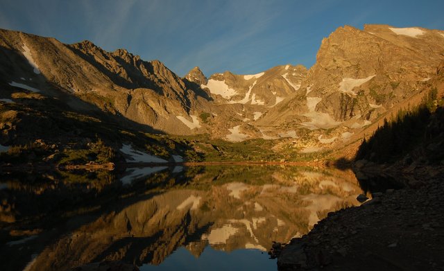
I followed the trail up the valley to the tiny unnamed lake, then surveyed the surroundings to pick the right line around the lake on the final off-trail approach to Airplane Gully. I stepped onto a small snowfield on the south side of the lake and immediately regretted it: the snow had refrozen during the night and my boots did not provide much traction. While rummaging around in my pocket I dislodged a pen, which fell skittering down the snow into the lake. I watched it fall, unwilling to move lest I follow it into the lake.
As I contemplated the fate of my pen, and the best strategy for climbing the snowfield, another solo climber appeared behind me, attired in a t-shirt featuring the golden arches over a portrait of Lenin with the text "McLenin's". We picked our way across the snowfield (I had much better luck gaining purchase on the snow when I headed straight up, rather than trying to contour around the lake; I had my crampons in my backpack but didn't want to drag them out to cross a tiny patch of snow), then scampered up the boulders on the south side of the valley in an ascending traverse toward the final basin at the base of Airplane Gully. I climbed faster than the other climber and reached the base of the gully well ahead of him. I stopped for a snack, watched a skier descend the Apache Snowfield below Navajo Peak, and headed up the gully.
The gully was filled with small scree, forcing me to step carefully to avoid dislodging rocks the size of small kitchen appliances. The rock and dirt were damp, binding them together, and the condition of the scree underfoot reminded me of the final pitch scampering up to the crater rim of Mount St. Helens. The gully turned to the right, and I followed it, and soon came face to face with the crumpled remains of an airplane wing, looking a bit like an angel's wing in the morning light.

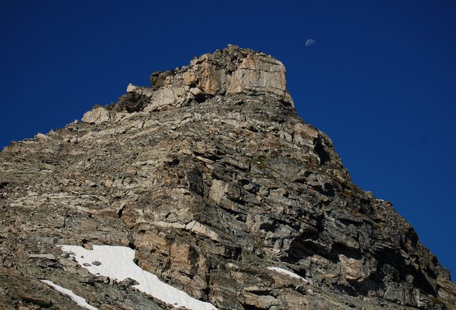
The Internet tells me the plane was a C-47 that crashed in 1948. I spotted more wreckage strewn around the gully and continued climbing. I reached the top of Niwot Ridge and continued west across the ridge to an ascending traverse to the base of the summit block. I chose my route carefully and, after a short pitch of class three scrambling, I stepped onto the summit. It was 09:00.
I ate lunch, used the self-test of my emergency beacon to signal Kiesa that I had reached the summit, and checked my phone for coverage. I got enough coverage to the west (presumably from Granby) to update Twitter and check my voicemail and e-mail. I checked the snow in the couloirs on Shoshoni Peak and saw that the snow had melted, but there was still about as much snow on the ground at the end of August this year as there was at the beginning of July last year. I identified peaks in every direction and noted the ones I had climbed, which seemed to be most of the peaks I could see in the Indian Peaks Wilderness and Rocky Mountain National Park.
The McLenin's climber reached the summit after I had been there for half an hour. We chatted for a bit and each pulled out our copies of Gerry Roach's Indian Peaks climbing guide. After nearly an hour on the summit I decided to head down, retracing my steps to downclimb the summit block, then scamper down the ridge to the gully, and pick my way down the gully. The gully seemed to take almost as much time to descend as it had to ascend; I had to step carefully lest I dislodge sizable rocks. Once out of the gully I hopped boulders down to the nameless lake at the mouth of the cirque. I stopped for a snack, perched on a large boulder in the lake, and watched hikers ascend the rough trail to Isabelle Glacier. I studied the cirque, trying to remember every detail; having climbed all of the surrounding peaks I wasn't sure whether I would return to this particular spot.
I descended the trail to the trailhead, through the crowds of people who appeared while I was climbing. The Long Lake Trailhead was packed, and as soon as I pulled out of my space a circling vulture grabbed it. I drove into Boulder and took a detour up Lickskillet Road into Gold Hill, then descended Sunshine Canyon in my first overt Fourmile Canyon Fire tourism. I had been at Brainard Lake on Labor Day last year when I first spotted the smoke, and I watched (and smelled, and breathed, and felt) the smoke on the plains but hadn't actually driven up the affected roads. I saw burnt-out forests, intact houses surrounded by burnt vegetation, burnt-out foundations, and new construction. The scope of the destruction was impressive, as was the apparent randomness of the path of the fire.
