Chiefs Head Peak
Started: 2011-10-19 07:47:52
Submitted: 2011-10-19 08:45:29
Visibility: World-readable
When the middle of September brought snow above 11,000 feet, I feared my summer was over, but the snow melted over the next several weeks, and by the first weekend in October I was ready to climb again. I set out to climb Chiefs Head Peak from its lengthy south ridge on Sunday, 2 October 2011.
I woke up alpine-early, drove to Wild Basin, and parked at the Sandbeach Lake Trailhead in the dark. I pulled out my headlamp for illumination and started the four-mile hike to the lake. (I've hiked to the lake itself as a destination, but today it was relegated to my approach.) After hiking a mile later I started to worry whether I had turned off the lights on my car. When I parked in the dark I needed a bit of light to see what I was doing, so I turned on my parking lights but didn't remember turning them off. (I knew my car would beep to warn me when I opened the door with the drive lights on, but I didn't remember if it would beep to warn me if I just left the parking lights on.) I debated turning back to double-check but didn't think that was necessary and pressed on.
I reached Sandbeach Lake in the early morning light a little before 08:00 and realized that I had forgotten to charge the AA batteries powering my GPS receiver, and I didn't have any spare alkaline batteries in my pack. (I also forgot my sunglasses, an easy mistake to make when I pack at night and leave early in the morning, forcing me to squint all day long.) I've grown attached to, and somewhat dependent on, the map on my GPS receiver for navigation, especially off-trail as the second significant part of my climb would be. I did have a printed map, but while I'm proud of my map-reading skills, locating my position, off-trail, on a map without any other equipment is tricky, at least at the level of detail necessary to make small navigational choices. I decided to press on, though cognizant that I was losing my margin for error, I resolved that if anything else went wrong I would abort rather than let my tiny mistakes compound.
I saw two people at Sandbeach Lake, and other evidence of camping (a bear canister on the sandy beach). I headed west around the lake and followed a sparse network of social and game trails onto the east-facing hillside forming the long ridge from Mount Orton to Chiefs Head Peak, separating the Hunters Creek drainage to the east from Lion Lakes to the west. (My topo map actually refers to this ridge as "North Ridge", as if it belongs to Mount Orton rather than Chiefs Head Peak.) I missed my GPS receiver immediately: it would have helped point me in the right direction up the forested slope.
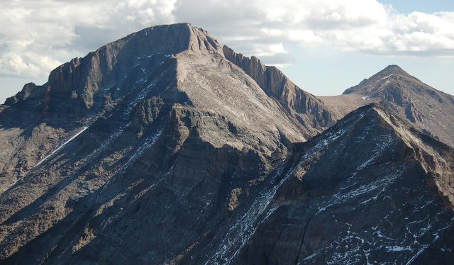
As I climbed the ridge, I caught glimpses of the large south face of Pagoda Mountain to the north and eventually entered a meadow clinging to the side of the ridge. This, I decided, was why I climbed: the broad meadow, the crisp fall air, and the expansive view of the rocky peaks to the north. I could see the south side of Longs Peak and its major buttress peaks. The Homestretch and Narrows looked snow- and ice-free, and with my binoculars I could see a number of climbers ascending and descending the route. I studied Keplingers Couloir from its base above Hunters Creek, and saw the Palisades blocking the direct route from Keplingers to the Loft, but didn't see anyone on any other routes.
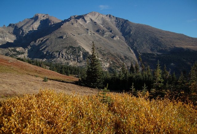
I climbed through treeline, negotiated a spruce thicket and a boulder-strewn unnamed point on the ridge, and finally got a good view at my destination: an uninspiring talus slope at the end of a very long ridge to the north. I looked west to the Lion Lakes and the sheer east face of Mount Alice and continued slogging up the ridge. I felt my strength flagging but resolved to reach the summit. I reached the ridge between Chiefs Head Peak and Pagoda Mountain, separating Wild Basin from Glacier Gorge, and looked (carefully) into Glacier Gorge, still shadowed from the morning light. I slogged up the ridge, hopped boulders when it seemed I was reaching the top, and finally reached the summit. I was standing on the third-highest point in Rocky Mountain National Park; only Mount Meeker and Longs Peak were higher, and I had climbed them both.
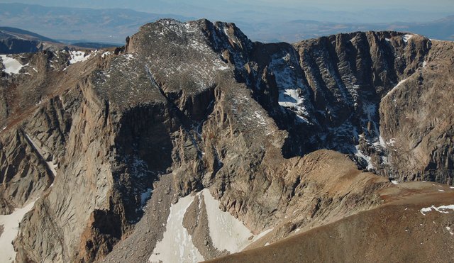
I looked into Glacier Gorge, looked at the other mountains in the national park and beyond, and pulled out my binoculars to study the Keyhole Route: I could now see the entire south and west aspects of Longs Peak, from the Keyhole through the shadowed-and-icy Trough to the brightly-lit and apparently snow-free Homestretch. I signed the summit register and searched (unsuccessfully) for names I recognized. I ate lunch and started my descent a little before noon.
I had gravity on my side for the descent, but that didn't make the long slog down the talus to North Ridge seem any shorter. I soon grew tired of the dead grass on the ridge but it stretched on for two miles before I began my descent to Sandbeach Lake. I had to guess at which point to descend, and when I caught glimpses of the lake through the trees I realized I was heading too far south. I altered my course to execute a descending traverse to my left, heading to the north, hoping to catch the lake and the trail on its north edge. I intersected the lake, bushwhacked around its western edge to the north, and caught the trail. I still had four miles to hike, but all I had to do was follow the trail downhill to the trailhead.
Even this proved easier said than done. I ran out of water and didn't want to eat the energy bars I had even though my blood sugar was crashing. I managed the first two miles down the trail ok but struggled to make the last two miles at a fraction of my normal pace. (It didn't help that my check-in deadline of 16:00 was approaching, though after my experience on Mount St. Helens I established a protocol governing the use of my emergency locator beacon to signal my safe return to the trailhead. When I was within sight of the trailhead, a few minutes after 16:00, I self-tested my beacon to signal that I was back, though the "I'm ok" e-mail and text message that I expected the self-test to generate took another forty-five minutes to reach Kiesa.) I eventually reached the trailhead, exhausted, and was relieved to see that I had, in fact, remembered to turn off my lights before leaving the car in the dark in the morning. I drove home, stopping to pick up a liter of Gatorade at a gas station in Lyons to rehydrate and refuel.
My experience bonking fourteen miles into a sixteen-mile hike reminded me of my experience on Kings Peak this summer. I resolved to rework my hydration and nutrition protocol: I need to make sure I can consume adequate calories, on the order of hundreds per hour (I think I burn roughly 500 calories per hour of aerobic hiking; I can't really expect to replenish all of those calories in real time but I can't rely entirely on my reserves), which probably means more sports drink, more energy bars that I actually want to eat, a bigger lunch, and a liter of Gatorade waiting for me in the car on my return.
