Heart Lake
Started: 2008-06-28 11:57:55
Submitted: 2008-06-28 12:38:57
Visibility: World-readable
The week before my four-day backpacking expedition in Lost Creek Wilderness, Kiesa and I undertook a brief, one-night trip in James Peak Wilderness as a dress rehearsal. I wanted to try out my gear and make sure I wasn't forgetting anything really important, and I needed to know whether I could use my Camelbak hydration bladder with my serious multi-day backpacking pack.
The largest of my packs (shown here returning from Toleak Point in Olympic National Park) is also the oldest of my packs; it apparently predates the hydration revolution and provides no obvious place to place a hydration bladder. I identified one candidate, a thin vertical pouch in the back of the pack. I was able to stuff my Camelbak bladder in the pouch, but it fell out of the top and the hydration hose wasn't quite long enough to reach my shoulder for easy access while hiking. Still, it was obviously better than nothing.
I rendezvoused with Kiesa after church on Saturday, 14 June and we headed up Boulder Canyon, turned south of the Peak-to-Peak Highway in Nederland, and turned west in Rollinsville to reach the East Portal of the Moffatt Tunnel. We ate lunch at a picnic area along the dirt road and parked at the end of the road in view of the tunnel portal. We strapped on our packs and headed up the trail along the South Boulder Creek towards Rogers Pass.
We encountered soft snow above 9,500 feet; I put on my gaiters to keep the snow out of my boots and broke out my trekking poles to provide a bit more balance on unsteady terrain. Above 10,000 feet, the snow was crisp enough that I could generally walk on top of the snow rather than postholing. Below timberline, the trail was fairly easy to follow; enough people had traversed the trail before us that I could follow their boot prints without much trouble, and the trail was fairly well blazed when one looked carefully enough. As we climbed through 11,000 feet and approached timberline, the trail became more difficult to follow; I began to rely more on my GPS receiver and the route I had constructed based on my GPS track from the last time I hiked this trail last June. The route, along with my general understanding of the trail, pointed us in the generally correct direction, though we ended up significantly off-trail at one point while climbing from Rogers Pass Lake to Heart Lake in knee-deep soft snow at timberline. This wasn't as big of a problem for me as it was for Kiesa; I had gaiters but she did not.
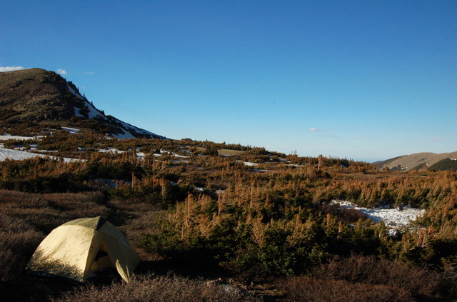
We reached Heart Lake and found, as I expected, sufficient flat terrain in the krumholtz zone around the lake to pitch our tent. We located a suitable site and I undertook another important research project: Could I pitch our tent by myself? The tent sleeps Kiesa and I comfortably; it's way too large for me to take backpacking by myself except for the fact that it's the only tent we own. (I like having enough space to turn around in, and while I definitely rattle around in the huge tent I don't feel at all claustrophobic inside. I could do better than 9.2 pounds for a tent, but I could also do much worse.) I was pleased to learn that I could in fact set up the tent on my own. I pumped water for supper and Kiesa cooked. Once we finished eating we retreated into our tent and ultimately went to bed.
I awoke in the middle of the night to relieve myself and found a vast array of stars -- more than I've seen in a long time -- and the unmistakable glow of civilization to the north-east down the valley. I considered the geography and concluded that it was most likely Longmont -- despite hiking roughly six miles, I could still see my house. Or, at least, where my house should be.
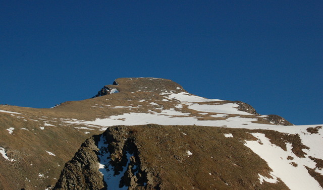
We awoke on Sunday morning and made preparations for departure. I would have liked to have ascended Rogers Pass and climbed James Peak, but the pass itself was snowed in; the trail was covered by steep spring snow and I didn't have the appropriate gear to attempt an ascent, especially since I didn't know what the conditions on the pass and the ridge traverse south to the summit were. I could see snow and bare areas on the rounded northern face of James Peak but I ultimately decided there was too much snow to make an ascent.
We ate breakfast, broke camp (in which I proved that I could in fact disassemble and pack the tent by myself), and descended the way we came. We arrived at the trailhead around noon and ate lunch at the same picnic area along the South Boulder Creek where we ate the day before. Having survived one night in the backcountry, I concluded that I could in fact survive a three-night expedition.
