Indian Peaks Wilderness (part 2)
Started: 2008-07-10 22:10:19
Submitted: 2008-07-10 23:29:21
Visibility: World-readable
See also: Indian Peaks Wilderness (part 1).
Saturday, 5 July 2008
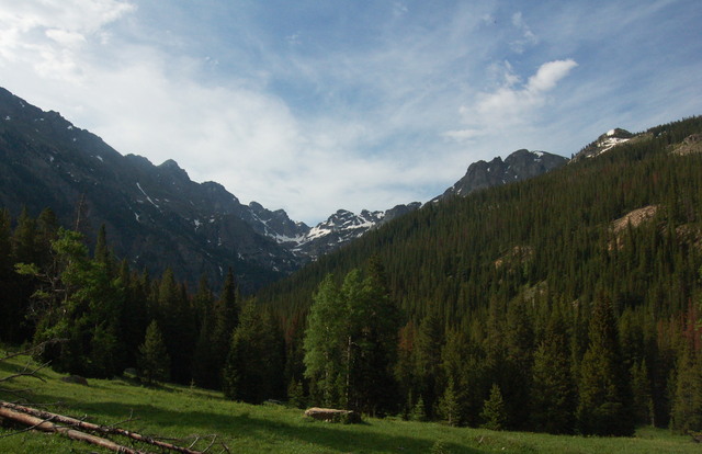
I woke up at the edge of a meadow above Buchanan Creek. Kiesa sent me to pump water for breakfast. After eating, we broke camp (which included setting the tent's rain fly out to dry; although it didn't rain overnight, the tent was wet when we awoke), packed our packs, and continued up the Buchanan Pass Trail towards Buchanan Pass.
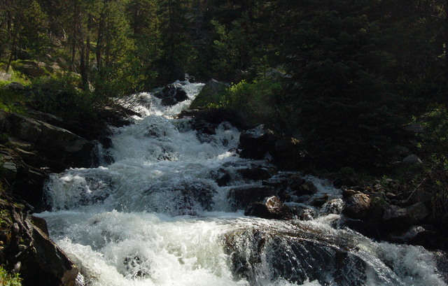
Shortly after leaving camp, we crossed Buchanan Creek on a pair of slick logs and began climbing the valley wall to the hanging valley containing Fox Park. Along the way we encountered a backpacking couple and traded notes on the trail conditions ahead. (The guy bore a slight resemblance to Swinyar in his speech patterns.) Along the north-facing slopes on the south side of the creek, we encountered large snow packs much lower than I expected to find them, but there were sufficient footprints to let us find our way across them. Before reaching Fox Park, the trail crossed Buchanan Creek at a fairly deep spot; the nominal ford was much too deep to wade through in my boots and expect my socks to remain mostly dry. Kiesa headed upstream in search of a superior crossing (which the backpacking couple we encountered earlier had indicated didn't exist). I exchanged my boots for sandals, hung my boots from my pack, and proceeded to cross the icy creek.
The crossing was only four meters from bank to bank, but it was knee-deep for most of the way, and the water was cold. I carefully made my way to the opposite bank, trying to keep at least three points (between my feet and my trekking poles) touching the bottom at any given time. By the time my legs started to get really cold, I reached the opposite bank and climbed out of the water into the bright morning sun. My legs dried quickly as I headed up the bank on the trail and tried to figure out how to find Kiesa. I headed upstream, keeping within view of the creek at all points. A hundred meters up the creek, I began wondering when I should start panicking when I heard Gem; she had crossed the creek upstream of me and was coming downstream to find me. I pointed out that getting separated at a tricky crossing was the worst possible thing we could have done; neither of us could have done anything to help the other.
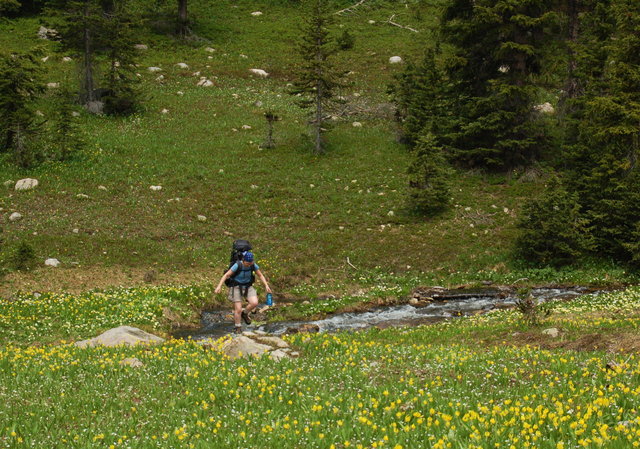
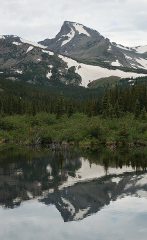
We put our boots back on and followed the trail into Fox Park, which was covered with tiny yellow flowers, and began the final climb up to Buchanan Pass. After climbing 1300 vertical feet, and crossing a few inconsequential snowfields, we reached the crest of the pass. We dropped our packs next to the cairn on the saddle and climbed the 500 vertical feet to the summit of Sawtooth Mountain. (Climbing Sawtooth has been an explicit goal since last summer.) The tiny summit left barely enough room for a summit cairn but I had a great view of Mount Audubon and Mount Notabon* to the south, Longs Peak and Mount Meeker to the north, a vast snow-capped range I couldn't identify to the west, and the distant plains to the east. (I figured I must be able to see where Longmont should be, though it didn't give me much to identify it by.)
[* Not an official name.]

After a snack on the summit, we descended via the north ridge, the same way we came and picked up our packs on the crest of the pass. Our next task was to descend to the east, which was easier said than done. A massive snow cornice hid just east of the pass, obscuring the trail. The best route around the cornice involved a hairy class-five move from exposed rock onto a sixty degree snow face above a hundred-meter-high slide. (With a heavy pack, this definitely counts as high exposure.) I went first and successfully traversed the snowfield onto safer ground, then watched Kiesa do the same.
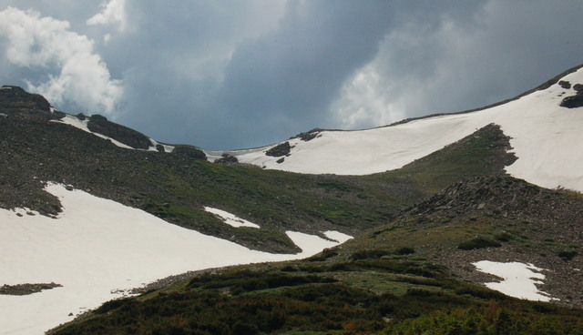
That wasn't the last good snowfield that the descent into the Middle Saint Vrain basin; we had to laterally traverse a steep snowfield, roughly following the course of the trail. Lacking an ice axe and the ability to self-arrest a slide down the mountain, I clung to the established footprints and dug my uphill fingers into the snow for balance. The traverse felt epic but had to have been at least two hundred meters. We gave up on another traverse and walked down a much gentler snowfield to the trail below.
After the second snowfield, the rest of the descent was easy. We encountered a few more well-packed, easy-to-follow snowfields on flat ground that didn't deserve mention. By late afternoon, I began considering our camping options in the vicinity of Coney Creek. It started raining and picked up when I decided to go off-trail to scout possible campsites. Though the terrain was gentle, finding a sufficient flat spot to pitch our tent proved more difficult than I would have liked. I eventually spotted a good flat spot that proved to be entirely too close to the Coney Lake Trail. By this point, I was soaked; my light raincoat was enough to keep my torso dry but I had nothing to keep my pant legs from picking up water from the branches I walked through. To make matters worse, my GPS receiver started behaving poorly in the rain; it powered itself off and wouldn't respond to control inputs when I tried to turn it back on. I stuffed it into my pocket and returned to the spot on the trail where I left Kiesa. We picked up our packs as the rain subsided and continued down the trail. I ultimately located a suitable campsite -- complete with a durable spot for our tent and an (illegal) fire ring -- in the vicinity of the junction between the Beaver Creek Trail and the Coney Lake Trail. (The campsite was close enough to the Coney Flats four-wheel-drive trailhead that we could hear engine noise despite being within wilderness.)
The rain had stopped entirely by the time we found our campsite, letting us set up camp and change out of our wet clothing without any further weather disruptions. The sky remained overcast for the duration of the evening.

After we retired to the tent for the night, we heard some rustling outside the tent, accompanied by what sounded like a distinct growl. Neither Kiesa nor I could see anything out of the tiny window at the front of the tent, but the noise didn't return and we saw nothing amiss in the morning and no tracks that would provide any other clues.
Sunday, 6 July 2008
I contemplated launching a side expedition to Coney Lake, which I visited several weeks earlier as part of a fact-finding mission, but it didn't seem compelling, so our only hike for the day was the five-mile hike south to return to our vehicle parked at Brainard Lake. The sky remained overcast as we ate breakfast, broke camp, and loaded up our packs for the last time for this expedition. We briefly exited the wilderness at the Coney Flats four-wheel-drive trailhead and continued south along the Beaver Creek Trail. It rained briefly, barely providing a sufficient reason to put on my raincoat, as we climbed through the forest on the flank of Mount Audubon. We encountered two trail runners coming in the opposite direction and I considered that our four-day, twenty-four-mile hike wasn't even as long as a marathon, though it did involve significantly more elevation gain and loss than any normal marathon.
As we approached treeline, we hit a few major snowfields that left me to navigate carefully to figure out exactly where the trail was. When we hit the highest point for the day, at 11,300 feet where the Mount Audubon Trail joined the Beaver Creek Trail, it started hailing with a good amount of thunder. We hurried to lower, more sheltered terrain at treeline; I held my trekking poles horizontally to avoid providing a conductive path to the ground. When I was surrounded by krumholtz trees I felt safe enough to grab my raincoat from my pack, which proved useful as the rain and hail continued for the duration of our descent. The trail seemed longer than I remembered it; I finally spotted cars through the trees as we approached the Mitchell Lake Trailhead. We hiked down the road to the Long Lake Trailhead, extending our hike by half a mile. We passed the same couple we talked to on Saturday as we walked; they had apparently just come over Pawnee Pass and were walking to their car closer to the Mitchell Lake trailhead.
It was still raining as we threw our packs in the back of Motoko and tried to dry off in the front seats. It was a relief to have a roof over our heads in the midst of a storm; I was glad that we didn't encounter this much rain until we were on our way out of the wilderness. Still, I enjoyed our four days in the wilderness.
