The top of Oregon
Started: 2017-06-13 22:37:19
Submitted: 2017-06-13 23:38:40
Visibility: World-readable
4 June 2017: In which the intrepid narrator ascends the highest peak in Oregon
My alarm woke me up at 00:01 on Sunday, 4 June. I set my alarm for a minute after midnight out of an abiding paranoia that my alarm might have strange ideas about when "midnight Sunday" was; and I didn't want to miss my alarm -- and my chance to climb Mount Hood -- because of a time conversion mishap. I changed into my climbing clothes, checked my gear, and we departed for the trailhead.
We drove to Timberline in the midnight dark. Willy suggested listening to "My Shot" from the Hamilton original cast recording, continuing our theme music from the weekend.
I parked in the overflow lot at Timberline, next to the Climber's Trail, and we walked to the climber's grotto to register for the climb. The grotto was full of climbers preparing for their ascent of the mountain; rarely had I seen so many people up and alert so early in the morning. (The only obvious parallel was my ascent of Longs Peak via the Keyhole route.)
We set out on our climb at 01:00. The snow on the climber's trail had frozen enough to be firm underfoot but still sunk slightly when I put my full weight on it, making careful step placement important. For much of the ascent we followed a snow cat track that had apparently just given a ride to a group of climbers; I couldn't help but feel slightly jealous as I contrived a justification that I could use: I had hiked to the top of the Climber's Trail yesterday, so I could justify continuing my climb from the top of the trail.
As we climbed a quarter moon descended and set in the west over the cloud cover. The clouds covered everything to the south and west below 6000 feet. Once we climbed high enough we could see the lights from Redmond and Bend to the south-east, and as morning wore on we spotted a morning star in the east.
Half-way up the Climber's Trail I suggested putting on crampons to aid in traction on the frozen snow, which helped immensely. (Here trekking poles would have helped as well, but I didn't remember to bring mine; and in any event it's an open question whether they're still in good enough condition to use.) We reached the top of the Climber's Trail after about two hours of hiking (about a half-hour faster than the day before) and turned slightly left to ascend the upper portion of Palmer Glacier towards Triangle Moraine. (The route schematic I found from Portland Mountain Rescue showed a waypoint labeled "Twin Rocks" that we climbed towards, though I was never able to actually identify what the label referred to.)
On Palmer Glacier the climber's footprints had spread out enough that we couldn't easily follow anyone's footprints. The snow field was uniformly frozen; with my crampons I delicately floated on top of the snow field with perfect traction in the flat-footed "French Style" (according to Freedom of the Hills) leaving only the most delicate bird-like footprints. I pulled out my ice axe for extra protection; the slope was frozen enough that I wasn't confident I'd stop without explicitly self-arresting with an ice axe.
As we climbed Palmer Glacier the sky began to grow gradually lighter in the east in a portent for the coming dawn. We could make out the bulk of Mount Hood looming ahead of us, though in general it was easier just to look at the trackless snow illuminated by my head lamp (and, on occasion, Willy's much brighter head lamp).
We reached the top of Triangle Moraine and crossed the small ridge separating Palmer Glacier from Zigzag Glacier as the sky grew light enough that I no longer needed my headlamp. A cold wind was blowing from the west, and I felt the cold and wet from my boots soak into my toes. (My boots are one of the first pieces of outdoor gear I purchased in the middle-aughts, and have probably exceeded their service lifetime, since their waterproofing has been thwarted by various structural flaws. At various points during the climb I felt boot envy as I looked at the proper mountaineering boots other climbers were wearing.) I felt my toes begin to go numb as I climbed in the cold and dark. I wiggled them with every step and they were still cold and unhappy but no longer numb. We followed the route, now along Zigzag Glacier, around to the right of Crater Rock into the volcanic vents at Hot Rocks.
I took a long rest next to Hot Rocks, feeling cold and tired from the climb so far and wondering whether I had the reserves to climb the last 1200 vertical feet to the summit above. Willy offered a backup fleece jacket which I put on under my outer jacket, and I immediately felt better and resolved to continue the climb.
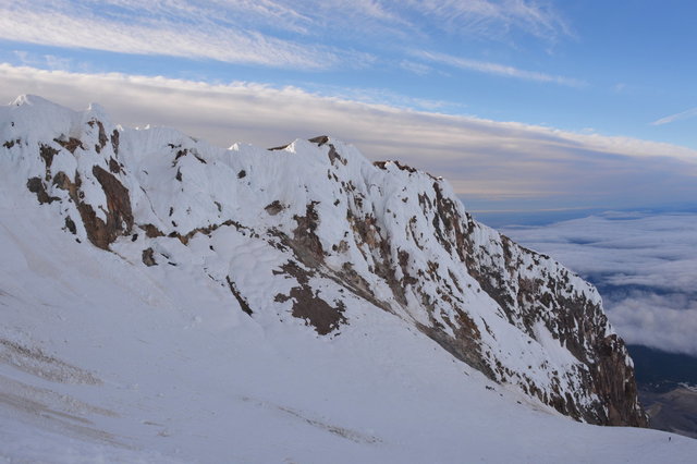
At Hot Rocks we were sitting at the base of a snow-filled cirque formed by Steel Cliff to our right (the southern extension of Mount Hood's summit ridge) and Crater Rock to our left (a large conical rock sticking out of the snow). The route performed an ascending traverse to our left, past Crater Rock to the snow ridge known as the Hogsback, then turned to the right to another ascending traverse under the Bergschrund* at the top of Zigzag Glacier. Here it was obvious that the preferred route was to bypass the Bergschrund to the right on what was probably a snowbridge over a smaller portion of the crevasse.
By this point the route was consolidated to the point of a single obvious trail, making further route-finding fairly easy. The sky above showed signs of dawn, and I looked around the side of Crater Rock to see Mount Hood's shadow on the clouds below, along with a sun halo effect -- sort of like a rainbow but in a tight circle around our shadow. (I've seen this halo while in an airplane, but never while on a mountain.) We were still in the shadow of the mountain, and would remain in shade until we reached the summit.
[* A massive crevasse at the top of the Zigzag Glacier; the picture above foreshortens its size because of the strong up angle. I'm capitalizing it here because of its importance on the route ("The Bergschrund"), but in general it's a generic noun.]
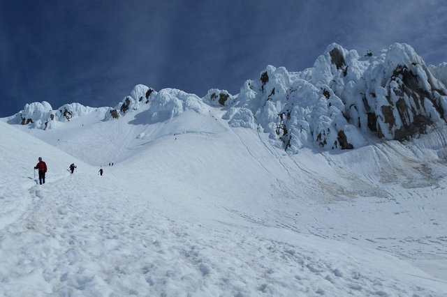
We followed the route up the mountain, divided into neat distinct pitches: traverse to the Hogsback; traverse around the Bergschrund (stopping to gaze into the crevasse and shiver as it gazed back into me); ascend to the right of the Bergschrund on a set of well-formed steps kicked into the frozen snow; ascend to the Pearly Gates.
Here we met some climbers descending from the summit, and other climbers that had turned back at this point not wanting to attempt the crux pitch. We had the choice of turning left into a chute filled with falling ice (some climbers complained that it was filled with marble-sized ice balls), or turning right into a steeper chute that probably had less ice. We picked the chute to the right, between the massive ice-covered buttresses to either side known as the Pearly Gates.
I led the climb through this crux pitch, which proved to be a steep climb on alpine ice. (I have basically no expertise climbing ice, but looking at the descriptions in Freedom of the Hills it looks like it's somewhere around an AI2 or AI3. My experience climbing snow in Colorado failed to adequately prepare me for the alpine ice on Mount Hood.) There were stable steps carved in the ice, and deep holes where I could sink the shaft of my ice axe, but the steps were filling with ice that had blown off the formations above. I could feel the effect of the altitude: I got less oxygen with every breath, so I had to take more of them to catch my breath after every step. I was pleased that I did not feel light-headed or otherwise experience the effects of altitude sickness.
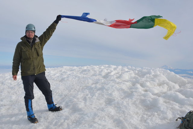
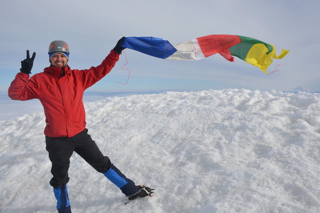
We climbed the crux, step by step, and gradually the chute opened up and the slope grew more gentle. The ice in the steps looked like it had formed right there; it reminded me of hoar frost, frozen directly from the moisture in the air. The final pitch led straight to the summit, a rounded lump of consolidated snow that formed the top of Oregon. We reached the summit at about 07:50, almost seven hours after leaving the trailhead.

The top of the summit was covered entirely in snow. A stiff breeze blew over the summit, and I didn't want to get too close to the edge since there was a good chance it was a cornice overhanging the steep north face of the peak. I looked gingerly towards the edge and ended up tagging the local maxima with my ice axe and calling it good.

Portland and the Willamette Valley to the west were entirely covered in cloud. To the north I could see the cone of Mount Adams and the truncated crater of Mount St Helens, with the massive bulk of Mount Rainier looming in the distance -- all covered in snow and punching through the clouds. To the south I could see the lodge at Timberline and Mount Jefferson (Oregon's second-highest peak), with another snow-covered summit we didn't recognize hovering over it to the left. (Since we'd spent all weekend talking about Hamilton and the early American republic I quipped that the other summit, in the shadow of Mount Jefferson, must be Mount Madison. A careful consultation of the map when I returned home suggested that it's North Sister.)
I ate a quick snack then plotted our descent. I didn't want to get too comfortable until we had descended through the crux. We left the summit at 08:10 to begin our descent. The first pitch of the descent was gentle, then we hit the crux pitch through the Pearly Gates. I turned to face the mountain to down-climb this pitch, using both hands and feet for maximum purchase on the alpine ice. I ended up using the pick of my ice axe in what I later saw Freedom of the Hills referred to as a dagger position, digging the pick into the ice to get a hand hold as I descended. The climb down took at least as long as the climb up because I had to test each foot-hold below me without a good view of what I was standing on. Gravity and I wanted to go in the same direction, but I didn't want to go anywhere near as fast as gravity wanted.
At the bottom of the crux pitch we let other climbers pass us going up, but some of the other climbers thought they would turn back rather than attempt the crux. We continued our descent on the steep but well-formed steps down to the Bergschrund, then enjoyed the gentle descending traverse down to the Hogsback. Only at that point did I begin to relax; it had taken more than an hour to descend down to the Hogsback (longer, in fact, than it had taken us to ascend), but from here it was just a very long hike back to the trailhead.
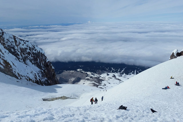
We ate a snack sitting on the Hogsback watching a pair of ravens attack a backpack that had been left on the snow. One of the ravens managed to use its beak to grab the tie on the zipper to try to rummage around in the snacks inside until I lobbed a couple of snowballs in its general direction to shoo it away. (It turns out the same sort of ties that make it easy for humans to open zippers with gloves also make it easy for ravens to open zippers with their beaks.)
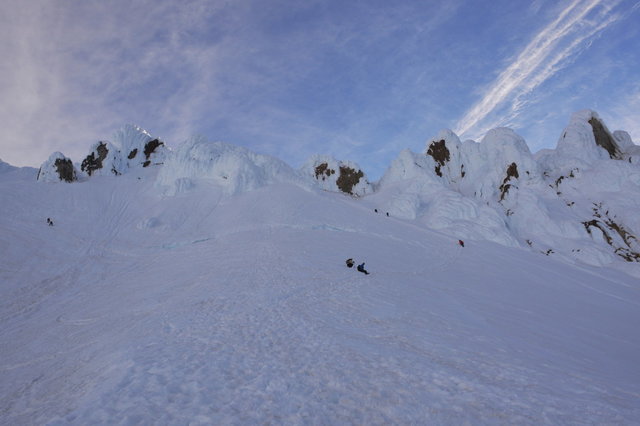
From the Hogsback we could survey the route we had descended. The picture above shows the route above Hot Rocks: the trail leads up from where I'm standing to the left to the Hogsback, then traverses under the Bergschrund, then climbs to the right of the Bergschrund. From there, under the patch of bare rock, the "old chute" climbs to the left and the Pearly Gates climb to the right. The actual summit is obscured by the gendarmes we see towards the right. (My camera's battery had died in the cold; I took the battery out and put it in an inner pocket for an hour, which was enough to warm it back up again.)
We continued our descent, descending down the fall line on the upper portion of Zigzag Glacier. The snow remained firm; it was difficult to get the right step rhythm going because I had to step carefully to make sure each foot gave me adequate purchase on the unyielding snow. I could see footprints and glissade tracks made in softer snow and sometimes used those to my advantage.

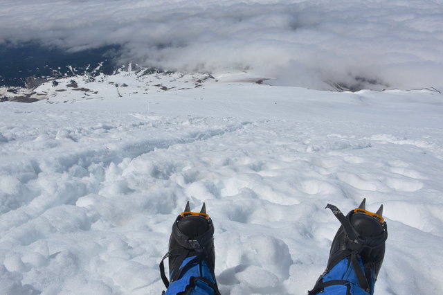
Halfway down Zigzag Glacier, where we had a good view of Illumination Rock above the clouds, Willy wanted to rest. I used the adze on my ice axe to carve out a spot to set my pack and a spot to sit myself while I waited for him to recover while I looked down on the lifts and trails at Timberline far below.
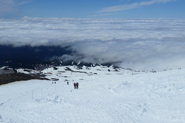
We resumed our descent and executed a descending traverse to wrap around Triangle Moraine to get onto the right descent path. (As multiple sources reminded us, if we continued to descend the fall line down Zigzag Glacier we'd run into the cliffs at Zigzag Canyon, which wouldn't be fun for anyone.) Once we were back on Palmer Glacier we had a straight shot down to the top of the climber's trail. The stiff snow quickly gave way to soft snow on the south-facing slope, letting me take big plunge-steps down the mountain without worrying about losing my footing.

We reached the top of the climber's trail and continued our descent as the snow grew even more soft, quickly crossing over into slushy.
Part of the Climber's Trail had been rerouted a hundred meters to the east to let the snow cats at Timberline claim more snow for their terrain park. They had just graded the trail in fresh (if slightly slushy) corduroy, and I was the first person to walk down it. It was a slightly weird experience to walk down soft untracked corduroy in crampons.
At length we reached the bottom of the trail. We stepped off the snow and onto the pavement at the trailhead at 13:00, a full twelve hours after we set out that morning. I was thrilled to have climbed Mount Hood, the highest point in Oregon, and a magnificent Cascade volcano.

For more photos from my trip to Mount Hood, see Photo set: Mount Hood.
