Borrego
Started: 2019-02-11 22:41:35
Submitted: 2019-02-12 01:12:49
Visibility: World-readable
19th January 2019: In which the intrepid narrator heads to Borrego Springs in search of somewhere dry to spend the weekend
As winter wore on in Seattle, I took the opportunity provided by the three-day weekend defined by Martin Luther King Jr. Day to escape the rain and go somewhere dry, sunny, and warm. I bought a plane ticket to San Diego to visit Anza-Borrego Desert State Park.
I departed Seattle on Saturday morning, 19th January, in the midst of the Trump Shutdown and the three-week window after the closure of the Alaskan Way Viaduct before the opening of the replacement tunnel carrying Washington state highway 99 on a bypass past downtown Seattle towards the airport. From our temporary rental in Ballard, SR-99 was the best way to get to the airport; now that we moved to Wallingford, we're located roughly between I-5 and SR-99. Local media predicted three weeks of "Viadoom", as traffic from the closed viaduct diverted to I-5 and surface streets downtown. But the epic traffic jams mostly failed to materialize, as the 90,000 cars that drove the viaduct every day mostly changed their schedules and working remotely -- proving not only that if you build it they will come; but also if you demolish it they will disappear. But I-5 was clear on Saturday morning; my Lyft took me to the airport without a hitch.
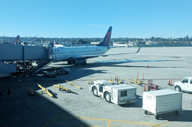
Despite his best efforts, the petulant toddler in the White House failed to disrupt my vacation: the crisis he manufactured over building a wall at the southern border led to a 35-day partial government shutdown, which left key federal government employees that I depend on for my air travel unpaid: the TSA agents providing security (theater) at the airport, and the air traffic controllers guiding the planes through the sky. But both of them were still doing their jobs when I arrived at the airport: I breezed through the PreCheck lane at the airport, and my plane received all the clearance it needed to fly me to San Diego.
I visited San Diego regularly for most of a decade, first while working for Solekai, then while working for Qualcomm, both of which maintains its headquarters in office parks on the north side of the city. My comprehensive flight database tells me that, prior to this trip, I visited San Diego 20 times between 2006 and 2015: twice to visit Solekai, once to visit Legoland, and the rest to visit Qualcomm.
For most of the three-hour flight to San Diego we flew above the clouds, thwarting me of a view of the Cascades and Sierras (combined with the request of my seat-mate to close the shade on my window to reduce the glare on his video screen). I glimpsed the San Gabriel Mountains and the Los Angeles Basin, then watched suburban Orange County slide past my window as we flew over the Pacific Ocean on the approach path into San Diego.
As we approached San Diego I glimpsed the Qualcomm buildings I knew so well in Sorrento Valley, all identified by their letters: Q, N, WT, AQ. From the air I could clearly see how close the suburban office parks were to Miramar Marine Corps Air Station; while visiting Qualcomm in San Diego I'd hear fighter jets flying overhead, climbing away from their runway for training exercises.

We landed and the first thing I noticed upon disembarking from the plane was that the airport had completed its terminal renovation, complete with a large window wrapping around a food court overlooking the tarmac. I ate a late lunch, then caught the shuttle bus to the combined rental car facility on the other side of the airport -- another change since the last time I visited (almost four years ago).
I picked up my rental car and drove out of the airport, on highways I recognized from my Qualcomm visits: merge onto the 5 (but stay in the right lane) to the 163, through Balboa Park under the Cabrillo Bridge, past the exit to the 805 (which I would have taken to get to Sorrento Valley) but instead merge onto the 15 to Poway. The scenery was familiar from my visits to San Diego, but this was the first time I'd seen it since moving to California three years ago; and comparing it against the Bay Area felt both comforting and alien: Everything was slightly different from the place I still consider to be my home, as if seen through a funhouse mirror.
In Poway I left the interstate and followed a series of parkways and highways into the mountains to the east, climbing away from the office parks and suburbs and strip malls into foothills covered in house-sized boulders and scrub brush. My route took me through the town of Ramona, nestled in a flat valley surrounded by rolling hills, then onward through a series of complicated turns where I was grateful to have Google Maps guiding the way.
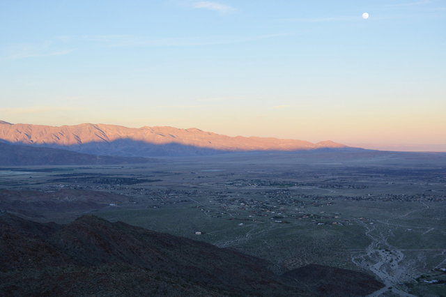
After an hour and a half of driving on a series of roads that seemed to get more narrow as I drove, I ran out of podcasts I wanted to listen to and switched my iPod to play the U2 album The Joshua Tree. I struggled to get the music to play on my rental car's stereo but ended up timing the opening bars of "Where The Streets Have No Name" perfectly with the moment when I crested the high point on the Montezuma Valley Road, pulling out of the tiny town of Ranchita, and heard the synthesizer swell as I looked east into the Imperial Valley, lit by the setting sun behind me, and I spotted the Salton Sea on the horizon just as the driving guitar kicked in. It was a magical moment for me, hearing the album dedicated to the deserts of the American Southwest, as I was at that moment driving into the Colorado Desert.
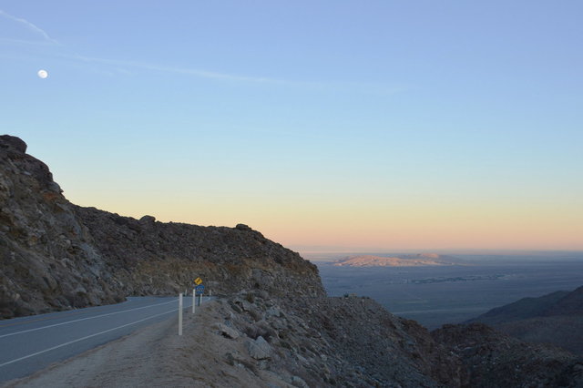
The road descended steeply into Borrego Valley, hugging the San Ysidro Mountains into the valley floor. I was struck by how green the valley was -- it was the middle of winter, and it had rained in the past week, feeding the seasonal grasses covering the valley floor. The sun was setting as I drove into the valley, lighting up the mountains opposite with the day's last light and plunging the valley floor into twilight, while an almost-full moon rose in the east.
I checked into the Palm Canyon Resort, a kind-of kitschy RV park plus western-themed motel sprawled out west of central Borrego Springs. I ate supper at El Borrego, a Mexican restaurant in town, and settled in for the night ahead of enjoying the desert the next day.

