Vancouver! Vancouver! This is it!
Started: 2011-07-21 21:09:19
Submitted: 2011-07-21 23:43:25
Visibility: World-readable
I set my alarm for 02:30 PDT on Tuesday, 19 July but actually woke up just before my alarm, having slept somewhat fitfully ahead of my planned climb of Mount St. Helens. I dressed and woke up Willy and my father, who rounded out my climbing party. I happened to glance out the window and saw a racoon skulking around the narrow street in front of one of the turned-over garbage cans. I walked outside to shoo it away (guessing, correctly, that even barefoot I would be a bigger threat to it than it would be to me) and saw a second racoon pawing at the lid of the collapsed garbage can, secured with some effect with a bungee cord. The raccoons scattered and I righted the can and returned inside for breakfast.
We departed right on schedule at 03:00 for the three-hour drive to Cougar, Washington. The road through Tillamook to Portland was nearly empty, though we did see some traffic in Portland itself. We reached Cougar a few minutes before 06:00 and waited for the front desk at the Lone Fir Resort to open so we could pick up the climbing permits we reserved earlier. I acquired permits for Willy and me in early May, when we first nailed down the dates for my climb; by the time Dad expressed interest all of the day's 100 permits had been sold, but I spotted a forum post offering several permits on the day we were climbing and suggested that Dad try to get them. He was successful and was able to join us on the climb.
With our permits we continued east to Climber's Bivouac, the trailhead for the standard summer Monitor Ridge Route. This trailhead had only recently opened for the summer; Washington, like Colorado, was blessed with epic late-spring snow that lingered far later into the nominal summer than one would have otherwise expected. (I brought my crampons and ice axe in my suitcase, and Dad and Willy rented their own, along with overspeced ice-climbing boots, at REI in Portland the day before.) The guy who gave us our climbing permits warned that the dirt road leading the last few miles to the trailhead was steep and rocky but we found it well-maintained and underwhelming, at least by Colorado standards.
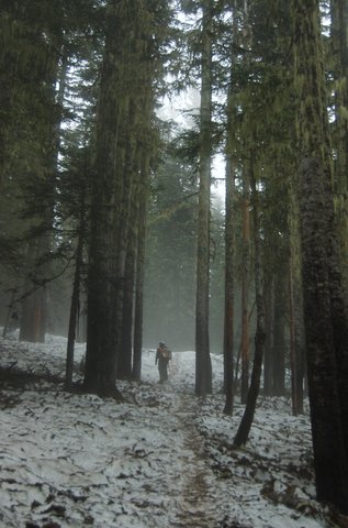
We gathered our gear at the trailhead and finally set off around 07:00. (I couldn't help but notice that I was more comfortable with my gear and my packing technique than the others in my party; I had my backpack packed the night before, and they were still rearranging and trying to figure out how to fit their plastic ice-climbing boots in their packs.) The snow pack started as soon as we hit the trail as we ascended two miles through an open fir forest from the trailhead (around 3700 feet) to treeline (around 4700 feet). Aside from the elevation, the biggest difference from Colorado's forests was the moss covering the trunks and branches; in the early-morning overcast light it gave the forest an ethereal, Elvish feeling but for the muddy snow on the ground.
At treeline the trail gave way to a route with trail-like characteristics. We ascended a series of snow fields interspersed with small rocky ridges and found ourselves properly on Monitor Ridge, named for the seismic monitors scattered on the ridgeline. The track led up a lengthy rocky outcropping but I suggested that we ascend the large snowfield immediately to the left, taking advantage of our snow-climbing gear. This necessitated a lengthy change of shoes, as the hiking boots the other members of my party wore were unsuitable for their crampons. (I wore the same waterproof hiking boots I wear every day, which did end up soaked by the end of the day; my boots were somewhat underspeced for the climb but their boots were clearly overspeced. The key difference was that my crampons would attach to any boot but theirs required a specific notch on which a lever would catch to lock the crampon into place.) I gave a brief tutorial on the proper self-arrest use of an ice axe and led the way up the slope.
The snow was packed and firm but I had no trouble kicking steps in my hiking boots. At its steepest, this snowfield was no steeper than 30°, though it had clearly drifted from the west: we stuck to the left of the snowfield, which was often much higher than the right side of the snowfield. I took the lead, to chart a reasonable course through the snow, having (by far) the most experience climbing snow, and had to spend much of my time waiting for the rest of my party to catch up. I began to worry about my timeline; I'd cautiously estimated that Willy and I might be able to make the climb in roughly six to eight hours (since we took six hours round-trip on Mount Elbert the previous summer, which was roughly equivalent for distance and elevation gained, though obviously different in absolute elevation and technical difficulty) and thought that, on the outside, we'd need no more than ten hours, so I'd left instructions with Kiesa that I expected to check in by 18:00 and if we were overdue she ought to consider calling search and rescue. (I also carried my brand-new emergency locater beacon in the event that we were sufficiently injured to need emergency evacuation but not so injured that we couldn't activate the beacon.) I had, however, failed to adequately consult the rest of my party while there was still time to alter my instructions and, more importantly, consider my father's physical condition. He instilled in me my love of hiking and mountaineering but since the time we lived in the same state and could hike together regularly his physical condition has declined as mine has improved. (I'm in the best shape I've ever been in during my life, judged at least by my Bolder Boulder time, which beats my father's (years-old) best-ever time by several minutes.) At the top of the snowfield, where we rested and snacked with 2000 vertical feet in a mile left to climb, I finally laid out my schedule concerns and expressed my doubt that my father would make it. It was nearly 11:00 and we'd spent nearly four hours so far. If we were to allow equal time on the ascent and descent (which might be warranted if we needed to pick our way carefully down snowfields or rocky ridges, but ignored the fact that we'd need to spend less energy with gravity on our side) I wanted to turn around by 12:00: five hours up, five hours down, with an hour to return to civilization by my 18:00 deadline. My father insisted on continuing, so I shrugged and we resumed climbing.

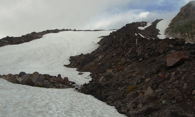
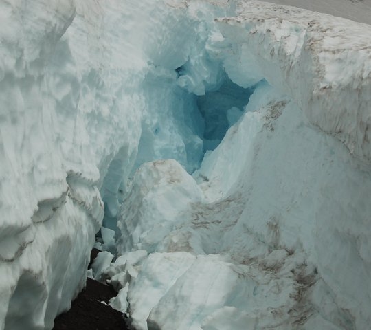
Dad and Willy wanted to continue snow-climbing up the snowfield that appeared to the right of the ridge. I stuck to the rock and picked my way around the talus near the crest of the ridge, within sight of the snowfield and the rest of my party. We climbed this way for another 1000 vertical feet until I spotted crevasses in the glacier and recommended we return to dry land for the rest of the climb. From there the clouds had cleared enough that I could make out what appeared to be the crater rim, 800 feet above us, and the upper reaches of Monitor Ridge appeared to be mostly scree: volcanic sand and ash, though wet enough that they would be consolidated and less slippery than a standard summer ascent. We continued climbing the scree, finding a rough track through the narrow spit between two snowfields, gaining elevation slowly.
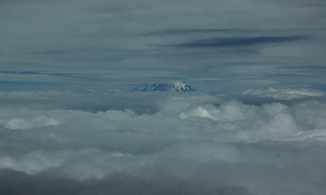
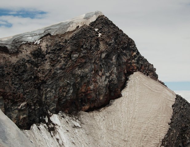
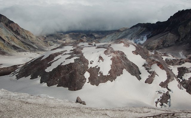
I finally broke away with a few hundred vertical feet left and reached the crater rim. The summit itself was somewhat anti-climatic; I could see the ground give way ahead of a giant snow cornice that I had no interest in ascending, not being able to see how much of it was actually overhanging and how much of it was merely perched precariously on the inner rim of the 1980 crater. I could see bits and pieces of the crater rim to my right and left; the ridge I had ascended was at the southernmost point on the crater rim, and the eruption blast blew toward the north. I spotted Mount Rainier through the clouds, visible only in a band between two cloud layers. I traversed the ridge to the west, toward the highest remaining point on the crater rim, and passed an overlook where I got a better view into the crater and the smoldering lava dome at its center. I could see the thousands of feet of the layers of rock that were cut away in the eruption and look beyond, through the throat of the hole carved by the eruption, into the devastation beyond, tapering into the clouds. It was unlike anything I'd ever seen before, and it was amazing.

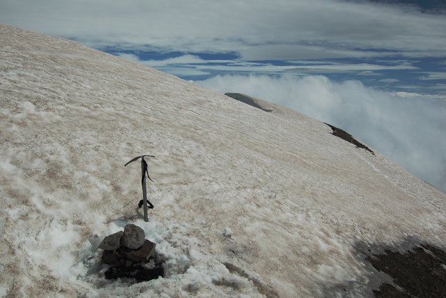
I down-climbed a pitch of muddy rock to a snow-covered saddle on the crater rim and ascended the snow-covered slope beyond, remaining careful to stay well away from the edge. As I climbed to the high point I didn't see any other bootprints or evidence that other climbers had come there recently. The snow was crisp and icy; I had some trouble maintaining purchase with my boots but didn't want to drag out my crampons just for the final pitch. At length I reached the crest of the ridge and cast about for the highest point. The map on my GPS receiver showed the summit to the east, but it appeared that the snow had been eating away at the scree forming the crater rim so my map was no longer fully accurate. I found a cairn, half-buried in ice, at 8,326 feet at what looked like the highest point of actual rock. I chipped away some of the ice, added my own rock, and declared victory: I'd climbed Mount St. Helens. It was almost 13:00.
I carefully picked my way down the ridge, retracing my steps to where Dad and Willy were talking to a group of Belgians on one of the crater rim's local maxima. Neither of them had any interest in reaching the formal highest point. We started our descent just as a snow flurry descended on us, which quickly abated into a windstorm that blew fog in our faces, clouded my father's glasses, and dropped visibility to a hundred meters at times. The scree was easier to descend than ascend, though the wind kicked up clouds of ash at our feet. Once we passed the obvious crevasses I suggested returning to the snow for an easier descent but it was still too windy for the others in the party to want to attempt it. We descended another 500 feet scrambling down larger boulders until the wind abated and headed to the snow to descend with crampons. Compared to the rock the snow was a breeze to descend, even if we maintained complete control and didn't try glissading or sledding as many other people had done. (Coming up I saw numerous troughs in the snowfields that I couldn't easily explain; going down I realized they were glissade tracks.) We continued our descent on the snow until we hit treeline around 16:00 with only the two-mile hike back to the trailhead. At treeline we removed our crampons continued hiking on the trail through the snow until, at last, we reached the trailhead sometime after 17:00.

Despite reaching the trailhead, we still weren't in civilization and still couldn't call home. We headed down the mountain, stopping in Cougar to indicate on the climb register that we had returned, and continued down the valley to the west. I underestimated the distance from Cougar to my first cell coverage in Woodland; since I was quickly running out of time to call home I should have tried to find a payphone, but I wasn't sure about the logistics of making long-distance phone calls on payphones, having rarely had the opportunity to do so. We finally reached Woodland at 18:20 and I called Kiesa, who was happy to hear from me but distressed that I hadn't called before my do-not-exceed time.
We still had a long ways to go before reaching home. Dad and Willy needed to return their climbing gear at REI in downtown Portland. While they were trying to figure out how to clean and dry the rental equipment before returning it, I spotted a coffee shop across the street and dropped in for a quick latte. We experienced another Portlandia moment in a tiny parking lot where an office worker was doing push-ups and lifting weights while apparently being instructed by his personal trainer.
We finally reached Oceanside at 21:00 PDT, eighteen hours after we departed, exhausted but pleased to have climbed Mount St. Helens.
