Calcite mine
Started: 2019-03-09 16:04:10
Submitted: 2019-03-09 22:20:56
Visibility: World-readable
19th February 2019: In which the intrepid narrator hikes to a calcite mine used in WWII gun sights, visits the Salton Sea, and experiences two different slot canyons
On my second day in Borrego Springs, I headed to the Calcite Mine site, in the eastern part of Anza-Borrego Desert State Park. (This time I actually remembered to bring my guidebook and maps with me.) The mine had been used to provide optical-grade calcite for use in bomb sights during the Second World War; though the only thing that remains today is a rough road, a couple of trenches where the calcite seams had been, and scattered calcite crystals on the ground.

I parked at the trailhead on the Borrego-Salton Seaway and followed the rough, four-wheel-drive road that clung to the side of the crumbling hills, formed out of something with a consistency between packed dirt and soft rock, prone to erode at the slightest provocation. Most roads in the state park followed the bottom of dry washes (and were rated as four-wheel-drive roads mostly for their tendency to get mired in sand and dirt and mud), but this road had a specific destination in mind, so it cut across the rolling rocky terrain: down into the bottom of the nearest wash, then back up the opposite side. It earned its four-wheel-drive rating as a rough road carved directly over the underlying rock, clinging to the side of the hill with little room for error before tumbling into the canyon below.

(I rented a giant Ford Expedition in order to have enough seats for my family when they joined me later in the week, and this vehicle did technically have a four-wheel-drive mode, but I was not interested in testing the quality of the roads, or my driving skills, or the capabilities of the vehicle lest I damage the vehicle or get stuck in the middle of the badlands miles from cell coverage.)
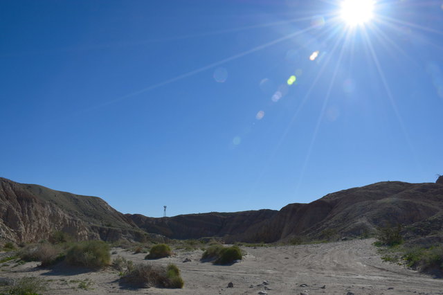
The road wound through the foothills of the Santa Rosa Mountains for a mile and a half, occasionally rewarding my efforts with a sweeping view of the crumbling hills of the badlands, cut through with Palm Tree Wash. (This name appeared to be false advertising; I did not see any palm trees in the wash during my hike.)
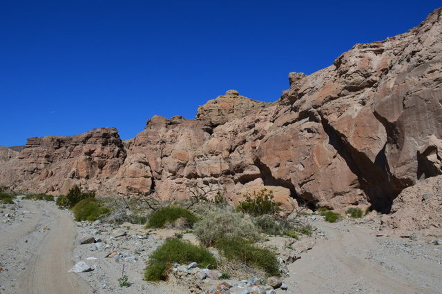
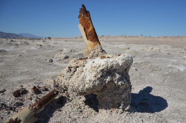
The site of the mine itself, at the end of the rough road, was a bit anti-climatic. It took me a few minutes to figure out what I was looking at, that the trenches I saw were carved into the rock by miners looking for the calcite seam that I could still see at the bottom of the trench.
Neither of the trenches looked very big, so I couldn't imagine they'd gotten very much calcite out of it; but it probably doesn't take much calcite to build a bomb sight.

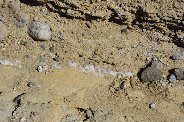
On the ground around the mine site were scraps of calcite crystals, most smaller than a half-inch. The scraps that were left didn't look all that impressive to me; it looked more like opaque quartz, but I have faith that the builders of the bomb sights knew what they were doing.
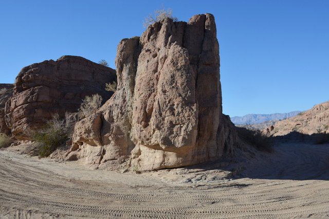
The first thing I saw, though, was Locomotive Rock, named because it looked like a mid-twentieth-century streamlined locomotive chugging through the desert.

From the mine site, I followed the route described in my hiking guidebook, Afoot and Afield: San Diego County, to drop into a slot canyon feeding into Palm Tree Wash. I followed a faint trail west of the mine, then found myself looking down a ten-meter cliff into the bottom of the wash. I searched the cliff until I found a carin marking a chute that I could scramble carefully down.

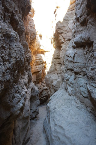
From the bottom of the wash the sandstone cliffs rose straight up, ten or twenty meters above the dry sandy bottom. I walked downstream and the canyon walls grew closer, closing in on a narrow slot canyon.
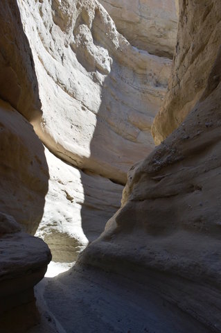
From the bottom of the canyon I could reach out and touch both sides with my hands. The canyon twisted and turned as I followed it downstream; I could see only a few meters ahead of me at any time, as if I were in a labyrinth. The rock walls were carved in graceful arcs, shaped by the eroding force of long-gone water.


At times I needed to reach out and balance my hand against the canyon walls to navigate a tricky drop or step over a small standing pool of water, and when I did, I brushed the palm of my right hand over the abrasion I'd received when I tripped and fell the previous day. My palm stung when I balanced it on the rocks, so I taped over the abrasion with the first aid tape I kept in my pack; and then, because the first aid tape only stuck tentatively to my skin, I taped a loop reaching all the way around my hand in an oversized bandage that proved sufficient to protect my hand from the rock walls.

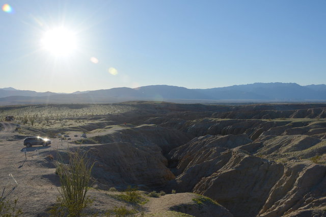
After 500 meters of slot canyon, the wash deposited me on the road leading to the slot canyon. I followed the wash further downstream, under the road clinging tenaciously to the hillside, expecting (as indicated in my guidebook) to find a path to loop back to the trailhead, forming a figure-eight loop.
The canyon opened up into a broad dry wash. I walked easily over the packed sand between sandstone cliffs climbing on both sides of the road. After a kilometer of walking I wondered where I might find my turn; and when I checked my guidebook I discovered that I had missed the turn shortly after the barrier indicating the end of the road for road vehicles, right when the canyon opened up. I checked my map (a low-resolution topographic map; I did not have the USGS 7.5' topographic map for this hike) and saw that I could continue down the wash, then double back to the west fork of Palm Tree Wash to return to the trailhead.

This proved easier said than done; after walking further I discovered that I had misread the map and mistaken a side canyon feeding the wash with the larger east fork of the wash. I could continue down the wash, but the junction I sought was still a kilometer away, so I decided to head into the gentle hills south of the wash and attempt to reach the west fork of the wash (and the easy route back to the trailhead) that way.
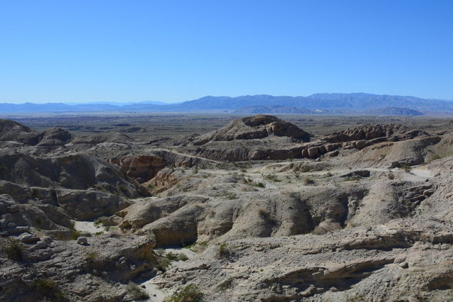
I found a faint track leading into the hills, which confused me, since I couldn't imagine why anyone else would have gone this way. (Perhaps they drove into the wash, then walked up to the crest of the ridge as a lookout.) I climbed to the top of the ridge overlooking the wash, then saw the complication in my plan: there were a considerable number of small hills between me and the wash I was trying to reach. I turned west, retracing my steps upstream but on the top of the ridge, following the ridge to the point where I knew I would intercept the trail.

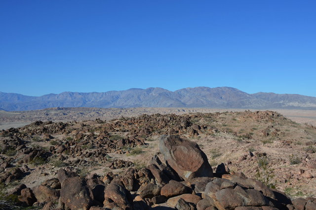
The terrain looked very different from the top of the ridge: it was dominated by small, book-sized rocks, with sweeping views of the mountains to the north and the Salton Sea to the east, with enough room to grow octillo and other desert shrubs. Once I reached the top of the ridge it was easy to walk across the open desert; though I found myself following a faint trail much of the time.

On the top of the ridge I found a mylar balloon trapped in a shrub, apparently blown downwind from somewhere, perhaps as far as the urbanized areas of Southern California, a hundred miles upwind to the west. I picked up the balloon as litter, then picked up another piece of the same balloon fifty meters away, and a second balloon a hundred meters away.
Just as I was beginning to wonder when I begin my descent to the west fork of the wash I was surprised to find people walking on the ridge. They were, in fact, on the trail; and I had in fact looped back to the trail as I expected, though I had intercepted it in a different place. I turned back to the trail and returned to my car, following the trail on its descent to the west fork of the wash, before finally reaching pavement, after an interesting but longer-than-expected hike.

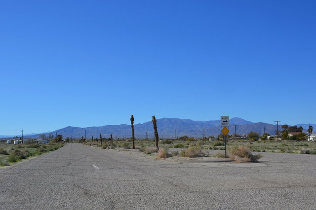
From the calcite mine, I followed the Borrego-Salton Seaway eastward, downhill, towards the Salton Sea, looming on the horizon, a strip of blue below the hazy hills on the other side of the Imperial Valley. The road took me through the Octillo Wells off-highway-vehicle state recreational area, a stretch of desert where dirt bikes and other OHVs could frolic (unlike the state park, where only highway-legal vehicles were allowed, and only on designated roads). As I drove I could see the plume of the gypsum processing plant in Plaster, on the southern end of the valley.
The road gradually dropped below sea level, a geographic quirk that went unnoticed here (unlike Death Valley National Park, where signs observed sea level at every point as the roads wound up and down the hills). I crossed the highway running north and south along this side of the valley and entered Salton City -- or what was left of it. On a map the city has large neighborhoods laid out with the elaborate graceful curves of a modern subdivision, but on the ground it was clear these roads had been built but the subdivided land had never been built. The lots that had been built were filled with boarded-up abandoned houses in various stages of construction with weeds the size of compact cars growing in the cracks in the driveway. Only occasionally did I see a house that actually looked like it was occupied. It looked like this was the furthest extent of the exurban development boom fueled by the housing bubble of the aughts, and when the bubble burst it left behind a ghost town.
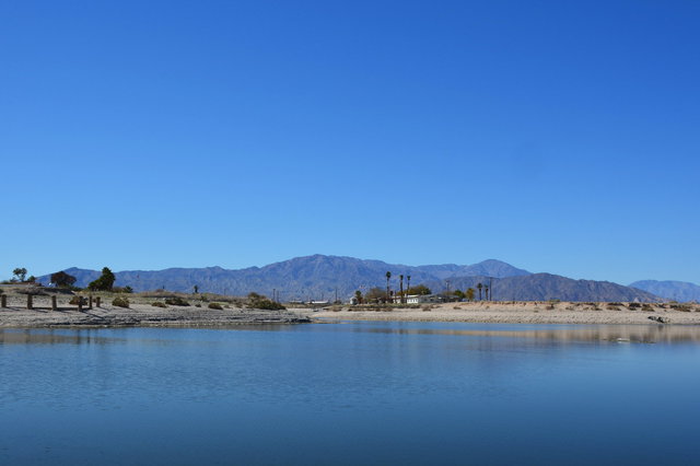
I turned onto a four-lane boulevard marked "Yacht Club Drive", proudly laid out with a sad colonnade of dead decapitated palm trees in the median. The road terminated on the shores of the Salton Sea in an abandoned parking lot, where dead palm trees loomed above the decaying pavement and weeds had overtaken the remaining planter beds.

I walked out to the shore of the inland sea, 232 feet below sea level, and looked out at the salt flat that stretched out to the water. I've flown over the Salton Sea many times, on my way into San Diego from Denver, but this was the first time I'd stood on the shore, looking out at the accidental inland sea in the ancient rift valley. The air was still, and almost perfectly quiet, far from the rush of truck traffic on the highway and the whining small engines at the OHV area.
(My employer identifies its offices using the three-letter codes of the nearest airport. Seattle's code, SEA, is also an English word, so I named my workstation "Salton". Every time I connect to my workstation I type "salton.sea", which amuses me.)

I walked out onto the salt flat, the salt-encrusted barnacles crunching eerily under my feet, past a once-proud house perched on the side of a pond (now separated from the main body of the sea), where someone was apparently still paying the water bills because the palm trees (desperately out of place in this hot-and-dry desert) still stood, alive, flanking the house as if to protect it from the neglect and decay all around.
I walked as far as I could to the edge of the water, where the salt flat gave way to mud at the edge of the sea.
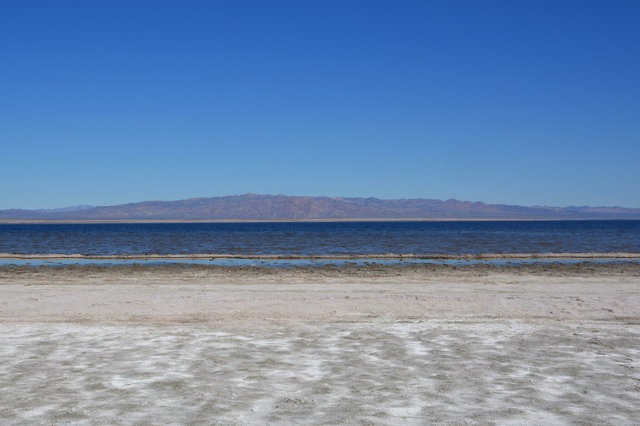
A few tenacious shore birds waded through the shallow water, apparently able to survive the salty polluted water, downstream from a million fertilized fields of the Imperial Valley. On the opposite shore the mountains rose into the haze. To the south the sea stretched to the horizon; and somewhere out out of view, beyond the curvature of the earth, on the other end of the Imperial Valley, sat the twin border town of Calexico and Mexicali. Behind me, as I stood on the shore, I could make out white patches of snow on the tops of the Santa Rosa Mountains; from here, on the interface dividing the blinding salt flat from the inhospitable brine, standing under the blazing midday sun (mercifully in the middle of February, the daytime temperature was a shirt-sleeve-comfortable 75 degrees), the idea of snow (or rain, or any precipitation whatsoever) seemed unimaginable.

I took a more direct route back to my car, parked at the abandoned yacht club, and walked across the skeletonized remains of six-inch-long fish, stacked on top of each other and stretching across the salt flat, baked into the mud and bleached by the salt and the harsh sun. This was, I presumed, the aftermath of the fish washed ashore by seasonal variations in the sea's surface level. I was grateful that I came at a time when the fish had been picked clean; the oder I smelled was vague salt mixed with the dry desert, not the overpowering stench of rotting fish I've read about.
I left the shore of the inland sea and drove south along the four-lane highway 86, then turned onto the two-lane highway 78, leading back to Borrego Springs. The road climbed gradually towards sea level, rolling gently through the hills formed by the dry washes slowly eroding the sandy soil. I turned off onto a dirt road leading to The Slot, a dramatic slot canyon cut into the soft rock, and parked among the cars at the trailhead.
Instead of heading straight into the slot canyon, I followed the route suggested by my hiking guidebook, Afoot and Afield: San Diego County, and followed a trail leading up the ridge towards the summit of West Butte. I ended up taking a wrong turn and ended up on a trail that diverted away from the summit before realizing my mistake and heading back towards the summit.
From the jumble of rocks on the summit I could see the valley wrapping around me, the mountains surrounding the valley on three sides, and the Salton Sea far to the east.
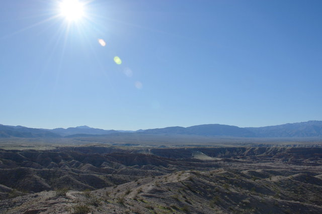
I descended the summit to the west, following a long ridge than snaked into the eroded badlands. My guidebook suggested that I could drop into the adjacent canyons, but I stayed on top of the ridge as long as I could, following the trail until it finally ran out of ridge and dropped into the wash at the bottom of the canyon. (I discovered, years ago while hiking in Colorado, that I like staying high on ridges, where I can see more of the surrounding mountains, rather than hiking through valleys.)
I followed the wash downstream a little while, then turned back to the south when I reached Borrego Mountain Wash, streaked with tire treads on the sandy floor as what passes for a four-wheel-drive dirt road in the state park.
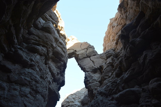
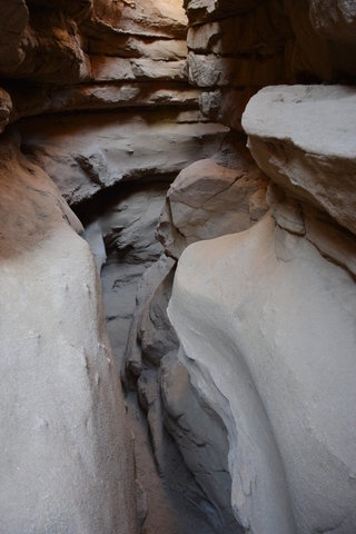
After some distance the road turned off to the side, and the canyon narrowed to a slot canyon (known, somewhat obviously, as The Slot). This slot canyon bore obvious resemblance to the slot canyon I hiked through in the morning, but it was more rugged, probably because the composition of the rock was different. (It was also more popular, since it had an easy road accessible to passenger vehicles leading right to it.) Some of the rocks were covered in what looked like dried mud (or if I squinted, sprayed concrete), suggesting that it had dripped onto the surface and solidified in place.
In some places rocks had fallen over the canyon, reminding me of the talus caves at Pinnacles National Park. I walked carefully under the overhanging rocks, willing them to stay up in position and not fall on me.
Part of the canyon was narrow enough that I had to take off my backpack and turn my body so I could side-step through the tiny deep channel cut through the rock.
I emerged from The Slot within sight of my car. I drove back to my hotel in Borrego Springs, then wrapped up my last night in town with tacos at El Borrego.
For more photos from my day in the desert, see Photos on 2019-02-19.
