The rest of Thanksgiving
Started: 2023-01-07 12:26:02
Submitted: 2023-01-07 14:07:08
Visibility: World-readable
The rest of Thanksgiving with my family: two state parks (the mission and a forest with a famous epicenter) and a family photo
Saturday
On Saturday, two days after Thanksgiving, my family spent one last full day with us in Santa Cruz at the end of the holiday weekend. Bethany and Josh went golfing at Pasatiempo, which they tell me is a famous golf course that just happens to be around the corner from my house. Kiesa walked the course with them as they played, leaving the rest of my family to see state parks in and around Santa Cruz.
Our first stop was the Santa Cruz Mission State Historic Park, on Mission Hill overlooking downtown Santa Cruz. The park contains the only surviving building from the original Mission Santa Cruz, and one of the few surviving adobe buildings in Santa Cruz County. The park was closed when I first moved to Santa Cruz County two years ago in the middle of the pandemic, and I had not visited it yet.
The centerpiece of the historic park is the long adobe building, a series of rooms built next to each other that had been used for various purposes over 200 years. We picked up a self-guided tour brochure and walked through the building, stepping into each of its rooms in sequence. Each room was set up to illustrate a different phase of the building's life. We saw cut-away views of the interior structure of the wall, places where the wall had been retrofitted to move doors and windows, and evidence of older foundations under the floor. In one room the walls had been plastered and wallpapered, and the whole room was decorated to then-contemporary 1920 standards, and each layer was cut away so we could see how the wall was built. The exhibits in each room included contemporary artifacts from each era the adobe was inhabited, and the displays interpreted the rooms and the artifacts and the people who used them.
Then we reached the end of the current adobe structure, with the mud brick walls quickly dropping away where they were exposed to the rain. The original structure continued on into the adjacent yard (now occupied by the Catholic school on the mission site) all the way to Mission Plaza. We looked around the grounds at the site, looking out onto downtown Santa Cruz and onward to Monterey Bay.
We returned to my house for what I desperately hoped would be a quick lunch, because we were running out of daylight for our second planned excursion, to the Forest of Nisene Marks. With some effort I marshaled my guests through lunch and back out the door to the state park in Aptos.
I first visited the Loma Prieta epicenter in 2018, and after moving to Santa Cruz County in 2020 I found myself hiking in the state park each year around Thanksgiving. This year it turned out that the main road into the park was open all the way to the summer parking lot; in November it's often closed at the winter gate a mile earlier, though it's not obvious to me what winter weather they're protecting against, since it never snows here on the central California coast. We set off following the fire road heading up the valley through the second-growth redwood forest, with Julian running ahead to the nearest curve then waiting for us to catch up, and Calvin alternating between chasing Julian and walking at a more reasonable pace.
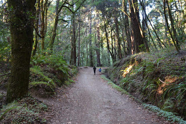
As we walked up the fire road, with Calvin and Julian somewhere ahead of me, I tried to remember what pictures I had taken on our first visit, and whether I could set up the same shot as before, four-and-a-half years later. The photo here is not exactly the same setup as this photo from 2018, but it's probably close enough.
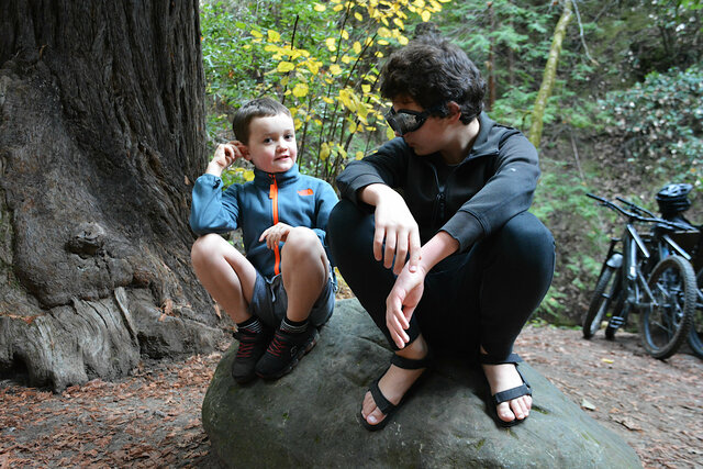
My kids, it turned out, were faster than my parents. We reached the turn-off where the trail to the epicenter diverges from the fire road and waited to see if they were going to catch up. (We had no cell coverage in the bottom of the valley surrounded by forest.) Eventually Willy turned back to find them. He was gone for a long time and I eventually decided to salvage the expedition with the people I had and press on to the epicenter by ourselves.
The trail leading to the epicenter is less well marked than it could be, starting with a crossing of Aptos Creek just below the junction. I've done the hike a couple of time so I remember that one is supposed to turn right on the opposite bank to catch the trail heading up the side of the ravine, but that's less obvious on the ground than one would hope. The trail seems to follow a railroad cutting through the hillside, then the railroad grade disappears over the creek into what I think it may be the trestle and cutting depicted in ruins in this 1952 photo posted by @SantaCruzTrains. The modern trail descends to the creek again for another crossing, then makes a sharp left turn on the opposite bank to ascend the slope before rejoining the railroad grade on the opposite bank.

From there the trail winds along the creek bank, gently ascending with the creek, before it dead-ends at a fence next to a marker proclaiming this spot to be the epicenter of the 1989 Loma Prieta Earthquake.
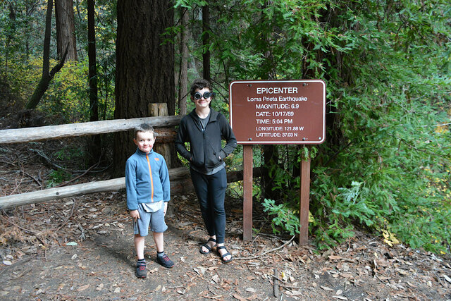
I understand that earthquake epicenters are not actually single points in the ground but rather probabilistic point clouds, which is how the state park can claim with a straight face that this point that happens to be right on an existing trail is in fact close enough to be called the earthquake's epicenter.
We turned back along the trail to head down the creek and rejoin the fire road to return to the trailhead. By the time we reached the road it was beginning to get dark; I pulled out my headlamp, fumbled with the batteries, and got it to turn on. By the time we reached the parking lot it was good and dark, and the headlamp kept us from tripping on the trail. I found Willy waiting in the parking lot at the trailhead: he had gone down the trail far enough to catch up with our parents, who had already turned around to make their way back. He headed back up the trail but we had already gone by the time he reached the junction, and he couldn't find the trail where it reappeared on the other side of the creek.
Sunday
On Sunday, the last day of the long Thanksgiving weekend, before my siblings and their spouses departed, we staged a family picture in the back yard, in front of my Meyer lemon tree. This proved somewhat more awkward than it ought to have been, because I had to line up the shot with my camera on its tripod, then get Josh to trigger the shot via my IR remote and self-timer. But the camera wouldn't stay in the remote-with-self-timer mode, so I still had to run back to the camera every time to evaluate the shot (to the extent that I could see the expressions and poses of ten people on the little LCD screen on the back of my camera) and set up the shutter for remote-with-self-timer again. This is how we ended up with both Calvin and Julian showing slightly strained expressions, because this was the shot where they looked best.

We had a great time hosting my family for Thanksgiving in Santa Cruz, and I'm glad everyone was able to come for the holiday.
