Hoover Dam
Started: 2023-11-09 21:52:53
Submitted: 2023-11-10 00:43:08
Visibility: World-readable
Visiting one of the wonders of the modern world
I had an entire day in Las Vegas before seeing U2 at the Sphere, so I left behind the glitz of the Strip to drive into the desert to see Hoover Dam. (I think I visited the dam in the 1990s as a teenager; this was my first visit as an adult.)
But first I had to charge my rental car. The drive to Hoover Dam was 35 miles one way; so a round-trip would be 70 miles, which seemed uncomfortably close to the 100 mile range my dashboard reported, because when I picked up my electric rental car it was only 35% charged.
I did some research in advance and found ChangeHub's map of charging stations, which told me that I ought to be able to find a charging station in the Luxor's self-parking lot, but when I looked closer the comments on the charging station, it indicated that it didn't really exist. (There was a charging station at the valet parking, but I did not feel the need to valet park my car.) These charging stations were "Level 2" stations, intended for all-day or overnight charging. I looked on the map and found a couple of "Level 3" stations (also labeled DC fast charging), which indicated they'd charge my car much faster (though a full charge would still be on the order of an hour, which seemed like longer than I really wanted to wait when I had places to be). The nearest was a couple of miles east of the Las Vegas Strip in a Target parking lot; there was another nearby in a Kroger parking lot.
(While scrolling the map I also discovered that I needed to pay attention to the charging station's network and compatible manufacturers, because not every electric car manufacturer wants to play with the other children. I knew Tesla had their own bespoke charging stations that were incompatible with other electric car brands. It also appeared that some of the Level 3 chargers were tied to Rivian and would only charge their cars. This felt like I had to find the same brand of gas station to match my car's manufacturer.)

I drove to Target and found the charging station at the edge of the parking lot, with three of the four spaces occupied. (This was a new experience for me; most of the time I ignore the charging stations and proceed to the unadorned parking spaces intended for gas-burning cars.) When I pulled into the open space the driver next to the space, sitting in his car waiting for it to charge, warned me that he couldn't get this charger to work. I tried the other cable (the charging port on my Hyundai Kona was conveniently located on the front bumper of the car, so I could pull directly into the parking spot) and the machine quoted me a cost of US$0.36/kWh. I gave it my credit card and it started charging, at what it told me was the car's requested charging power of 52 kW.
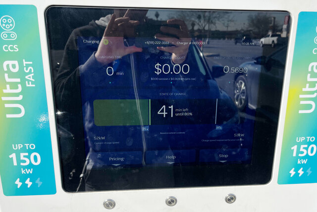
I sat in my car for a bit to wait for the car to charge, then went into Target to get snacks for my trip, and coffee from the embedded Starbucks. After 28 minutes of charging, my car had received 28 kWh, bringing the state of charge up from 35% to 69%. (If I wanted to wait another 10 minutes the display informed me that my charge would hit 80%; but at that point it would start to charge more slowly to avoid stress on the lithium batteries.)
My dashboard informed me that my car was traveling on average 4.5 mi/kWh, so in 28 minutes I had charged enough to travel 126 miles. At the quoted price of US$0.36/kWh it cost US$0.08/mile. In my Rav4 at home, I get about 25 miles per gallon, and if I'm lucky I can get gas in California for $5/gallon, so I pay US$0.20/mile in fuel alone for my gas car.
(The fast-charging station was a reasonable experience, but still an order of magnitude slower than refueling a fossil-fuel car.)
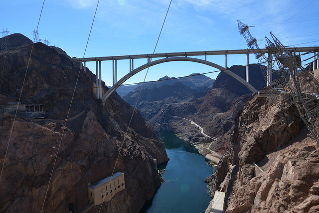
With my car charged I set out to drive to Hoover Dam, 45 minutes south-west of Las Vegas on the Colorado River. The route took me on a new Interstate highway, Interstate 11, bypassing Boulder City on the way to the dam, before I turned off onto the dam access road, following the route of what used to be the only highway crossing the Colorado River between Nevada and Arizona until a new bridge was built in 2010.
After a vehicle security check (which appeared mostly to be check whether I had anything in my trunk) I descended into the canyon, negotiated a hairpin turn in the shadow of the huge new concrete arch bridge dominating the landscape downstream of the dam. I parked in the large parking garage, tucked into a side canyon, colored to match the rock walls of the canyon, carefully built around the existing towers supporting high-voltage power lines running away from the dam's powerhouse.
I arrived at the visitor's center at noon and learned that the next available big dam tour was at 13:30. I signed up for the tour, then headed straight into the theater for a short video giving the history of the dam. The video talked about the Colorado River Compact dividing the water of the Colorado River, setting up the legal framework for water distribution used to build the dam, but neglected to mention that the tribal nations bordering the river were excluded from the compact, or that the river's flow was divided based on a historically high water year, two problems that continue to haunt the entire river basin to this day.
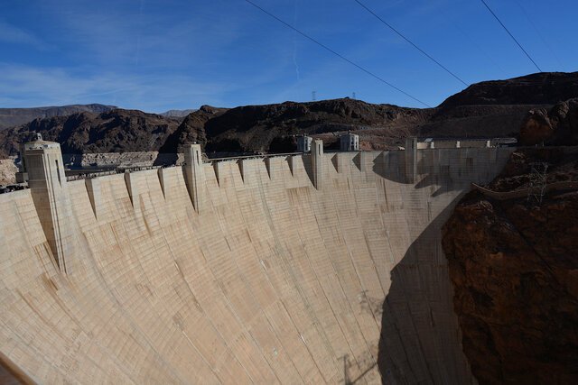
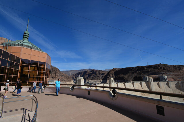
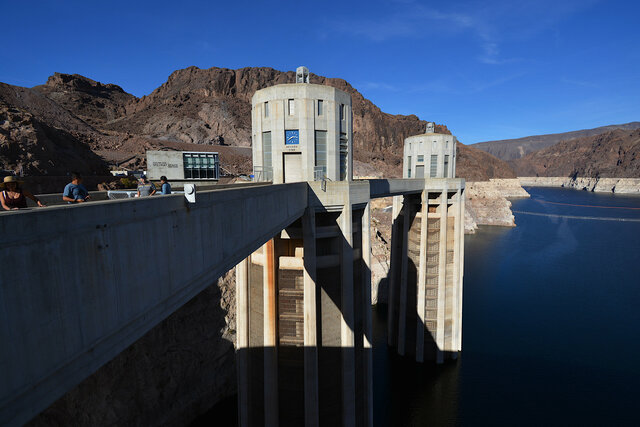
After the video I climbed the steps to the observation deck on the top of the visitor's center, giving me a view of the concrete arch dam gracefully wedged between the rock canyon walls. I took the picture above standing carefully so I wasn't quite leaning over the edge of the balcony so I didn't have to see the drop right below my feet.
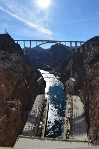
Immediately downstream was the new bridge carrying the bypass highway over the canyon, arching gracefully between the canyon walls over the Colorado River far below.
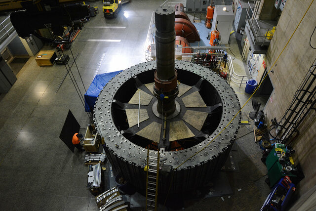
I took my time going through the exhibits in the visitor's center, covering the dam's construction in greater detail, including an interesting life-sized cut-away model of the generator rotors, giving me the chance to walk through a replica of the the machinery running in the powerhouses below the dam.
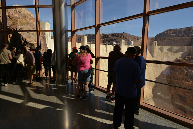
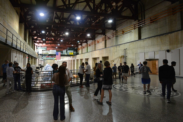
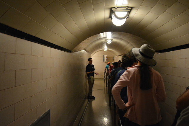
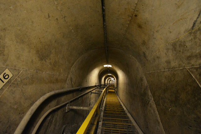
I showed up for my tour at the scheduled time, listened to a brief introduction from our tour guide, and got another view of the dam through the floor-to-ceiling windows. We took the elevator at the back of the visitor's center 500 feet below us into a network of caverns carved out of the rock forming the canyon walls. The floors had been paved with a smooth concrete walkway with curbs on either side, and metal railings ran the length of the corridors on both sides, but the walls and ceilings were raw living rock.
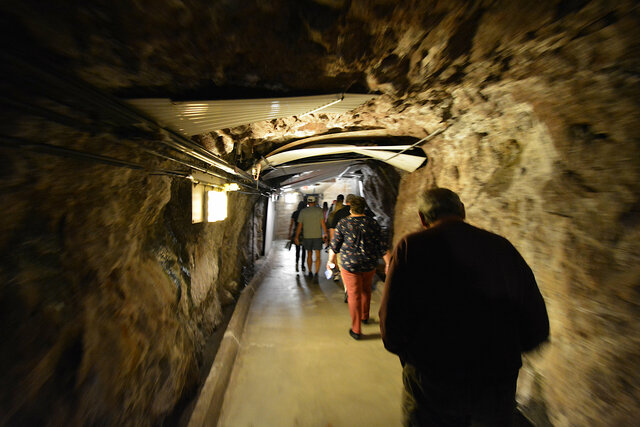
In some places corrugated sheets had been draped awkwardly over the walkway, presumably to catch water dripping through the rock before it hit the people walking below. This was a space that had been painstakingly carved through the rock so we could see the much larger spaces carved into the rock.
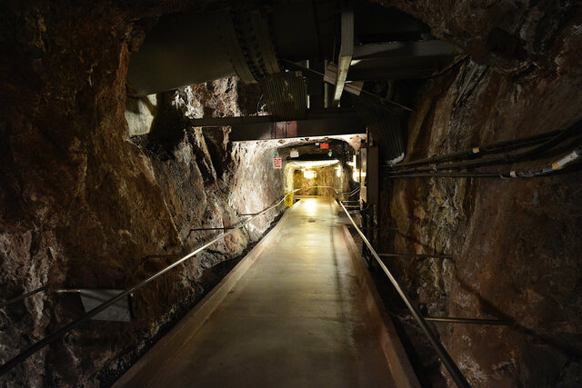
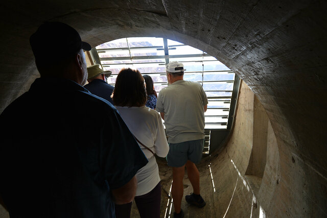
For the first part of the tour, we joined the shorter powerhouse tour, which started by taking us deep into the canyon wall to see the penstock carrying the water from the intake towers on the face of the dam to the powerhouse. We stood on an observation deck perched in the diversion tunnels originally built to move water around the dam, which now carry water through the dam. (In the picture below we are looking downstream; water is flowing under my feet in the direction I'm facing through the huge pipes. The view from the other side of the observation deck looks much the same, except that I could see another identical observation deck in the tunnel.)
The powerhouse tour guide showed us a diagram of the dam so we could see where we were with respect to the dam and the powerhouse and the other features we could observe from the surface.

We returned to the elevators to descend further into the rock and emerged into the powerhouse on the Nevada side of the river. Our viewing platform stretched in an L shape at the end of the powerhouse; It was hard to get a good view of the long and skinny room from the far end, with all of the generators lined up in a row in front of us.
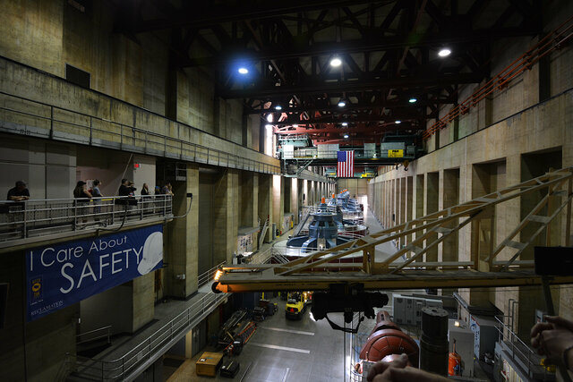
Our dam guide pointed out that the primary purpose of the dam was water storage and management; electrical power was almost incidental. When the dam was first built, different cities bought power from specific generators, so some of the generators were built to be half as large as the others, but now all of the power goes into the grid. The dam managers release water through the dam, generating power along the way, to serve the water needs of downstream people, and they often release more water in the evening to reduce evaporation.
One of the generator shafts was being retrofitted as we watched, which appeared to involve the worker in the orange shirt to the left of the shaft cutting pieces of metal with an angle grinder.
The tour wrapped up in the powerhouse, and the larger group headed back to the top of the dam, but the people in my tour group showed our wristbands so we could continue into the dam itself. We walked through a series of corridors finished with tile on the walls and ceilings (looking very much like subway tile), which had been built to be part of the tour route through the dam. Our guide answered more questions about the dam, then took us into an elevator in the body of the dam itself.
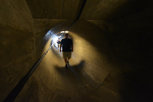
Our guide led us down what looked like the main corridor running the length of the dam, curving gently in each direction so we couldn't see very far ahead or behind us, until we reached a locked gate and a long perpendicular shaft heading straight out to the downstream face of the dam. The corridor had a flat floor and square walls; this shaft had a perfectly circular cross-section, created when the dam was built by setting wooden boards in a form and pouring concrete around it.
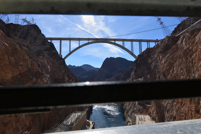
The corridor ended at a vent in the downstream face of the dam. We were part-way up the dam; from here we could look out and see the powerhouses on both sides of the canyon and the concrete arch far above us and the river below. When I reached the front of the line I quickly snapped a couple of pictures and stepped aside to let others get a view.
Our tour guide warned us in advance to be careful sticking our cameras and phones through the vent, because if we dropped them, they would be gone forever.
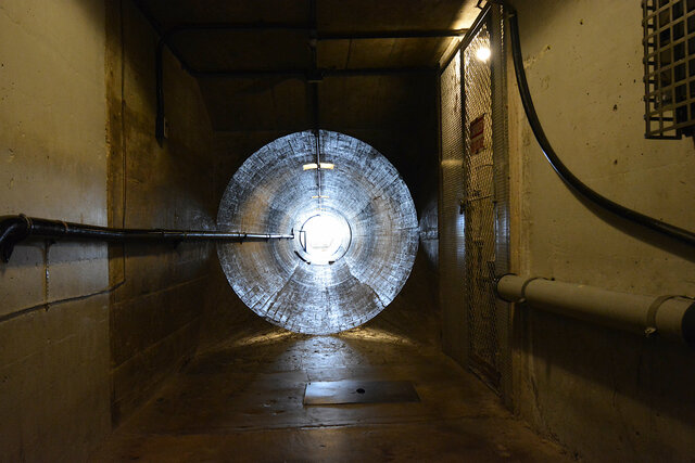
I lingered at the end of the group to get a picture straight down the shaft leading to the vent, lit brightly by the sun on the face of the dam in contrast to the yellow electric lights inside the dam.
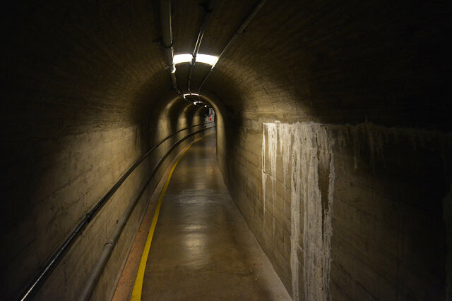
Our guide led us down the main hallway through the dam, heading to the west (towards the Nevada side of the canyon) so the corridor curved gently to our left. (The picture below faces east, towards the Arizona side.) Here the form work that created the walls and ceilings were visible: broad planks maybe six inches tall for the walls, and smaller planks maybe two inches tall for the arched ceiling.
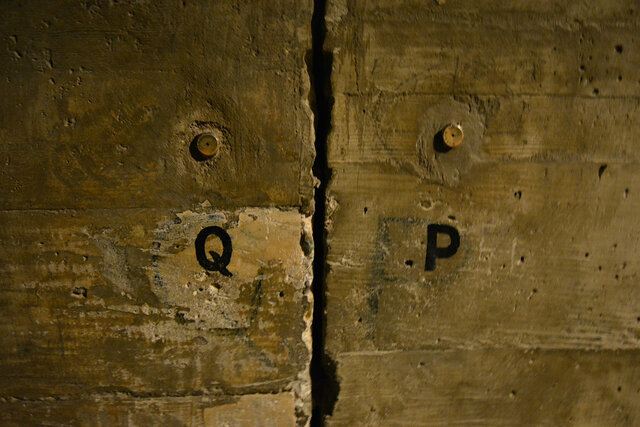
As we walked we could see the joints between the sections of the dam, complete with monitoring points so engineers can check how the sections move over time, and take action if necessary, such as by injecting grout between the segments to try to stabilize the giant concrete blocks that make up the dam.
Our guide took us to the end of the corridor and around the corner, and let us look down the long stairway running deeper into the dam (curving gently to the right as it descended) and in the opposite direction another long stairway climbing towards the surface, curving gently to the let as it ascended.
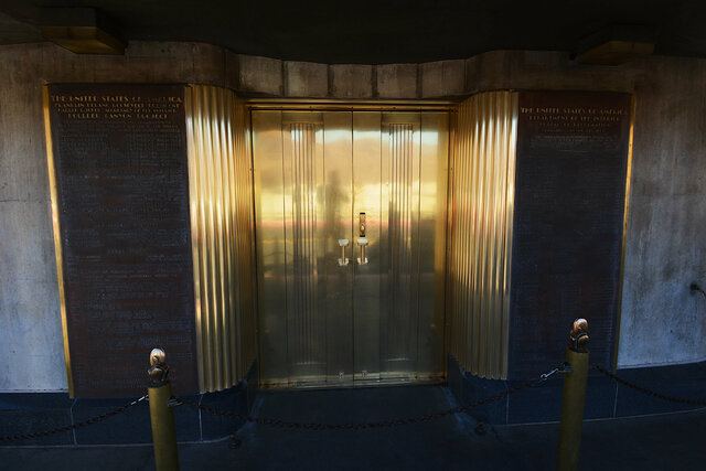
And then our guide took us into the elevator and we ascended the rest of the way to the top of the dam, emerging on the street level through elaborate art deco doors under one of the towers on the downstream face of the dam, on the sidewalk next to the two-lane roadway running over the top of the dam. Our tour was over and we'd had an amazing experience in the depths of one of the wonders of the modern world.
I looked carefully over the edge of the dam, near the mid-point of the river, for another view of the river at the bottom of the canyon.
I walked east across the bridge, crossing the middle of the river onto the Arizona side. (This meant that I crossed into a new time zone, though Arizona in Mountain Standard Time observes the same offset as Nevada in Pacific Daylight Time, so my clock didn't actually change. I did take care to tag the photos I took on the Arizona side of the dam in MST. The intake towers on each side of the river showed "Arizona Time" and "Nevada Time"; I visited two days before the end of Daylight Savings Time so both clocks showed the same time.)
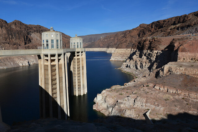
From the Arizona side I got my first good look at the end of Lake Mead behind the dam, visibly far below the high-water mark on the side of the canyon. Our guide pointed out that the lake had risen 25 feet from its low point last year after the wet winter, and expressed optimism for another wet winter ahead. (At the end of October 2023, the Bureau of Reclamation reported the level of Lake Mead at 1065 feet, above 2022 and close to 2021, but still below historical levels.)
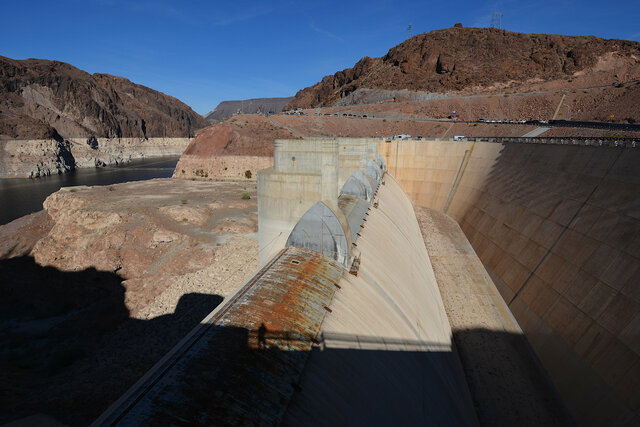
I looked into the spillway on the Arizona side and marveled at the massive concrete structure designed to route excess water around the dam, high above the current water level, and unused since 1983. It's not obvious from this view but it looks like the high water mark on the canyon walls is as high as the spillway, a water level not reached in 40 years.
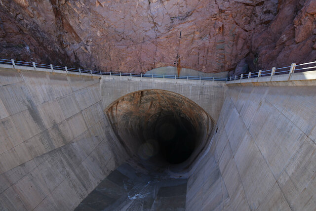
On the other side of the roadway I looked down into the tunnel that would carry water from the top of the spillway into the lower section of the diversion tunnels dug when the dam was built, and from there into the canyon below the dam.
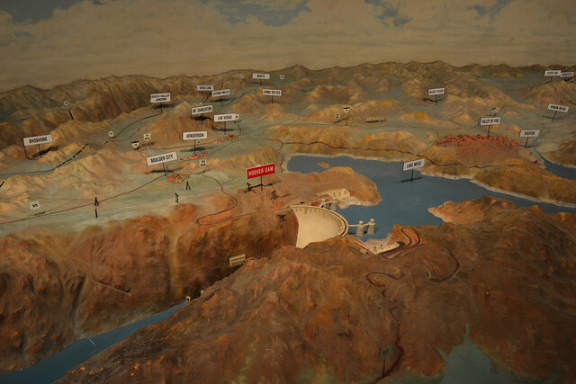
I walked back across the dam (back into Pacific Time) and stopped in the original visitor's center, which now houses a large diorama depicting the entire Colorado River watershed and the adjacent regions of Southern California connected by canal, originally built when the dam was first built to educate visitors, and still used for that purpose. I arrived in time to see the presentation, with a recorded voice narrating the features of the watershed (and the Bureau of Reclamation's work on the river) accompanied by lights illuminating specific features at the right moment. It was a bit old by modern standards, but charming in a slightly-anachronistic manner.
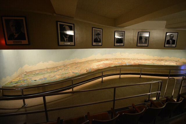
After the presentation I looped back to ask the person staffing the entrance about the history of the diorama, and she was so excited that someone asked questions and expressed interest in her favorite exhibit that she told me all about the history and construction of the diorama. It was built to three separate scales: a horizontal scale, a vertical scale for the terrain, and a different vertical scale for the dams. The model was originally intended to have real water (I thought about the Bay Model replicating San Francisco Bay with real water) but was changed at the last moment.
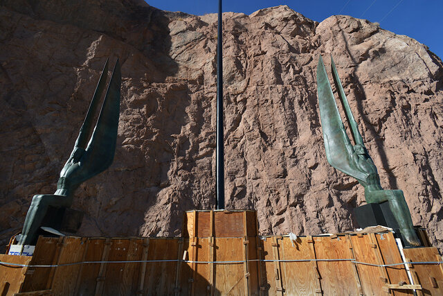
The last thing I saw heading back to my car were the Winged Figures of the Republic, protecting the dam but currently being repaired so I had to peek over a fence to get a look at them.
I stopped by the gift shop on my way out, then headed back to Las Vegas to see U2 at the Sphere (about which, more later).
I took even more pictures at Hoover Dam than I included above. They're all at Photos on 2023-11-03.
