North Arapaho
Started: 2010-09-08 20:40:09
Submitted: 2010-09-09 22:21:19.587353
Visibility: World-readable
Last Saturday, I set out to climb North Arapaho Peak. It's easily visible from my office (at least, when Boulder's foothills are not inundated with smoke from nearby wildfires), and I've been up to the glacier overlook on at least two occasions and all the way up to South Arapaho Peak once. The class-three scramble from South Arapaho Peak to North Arapaho Peak is included in Dave Cooper's Colorado Scrambles: Climbs Beyond the Beaten Path, so I figured it'd be a worthy climb.
Compared to some of my recent nine-hour expeditions (McHenrys Peak, Mount Julian), North Arapaho Peak looked like a relatively short climb I could finish in six or seven hours. This meant I didn't, strictly speaking, need to get up excessively early, but I had been getting up at 04:00 for my last several expeditions and decided to keep the trend.
While eating breakfast at 04:00, I got distracted by trying to install a still-very-beta-but-actually-almost-working version of PockeTwit, a Windows Mobile Twitter client that actually had almost-working OAuth support in a desperate attempt to get a Twitter client I could actually use in the wake of the great OAuthcalypse. (I'm sure OAuth is a great idea, but I'm still upset that my mostly-working Twitter clients suddenly stopped working while I wasn't watching last week, and it took me a few days to actually figure out what was happening.) A bug in the dev build kept me from actually being able to properly authenticate, so I finally had to write off the whole experiment (after spending an extra forty-five minutes struggling with it after finishing breakfast) and set up my phone with Twitter so I could simply text messages directly. This too seemed doomed to failure until I realized that I had already added my phone number to Twitter, and my attempts at getting Twitter to communicate with me and log me into my account were actually being relayed directly to the world.
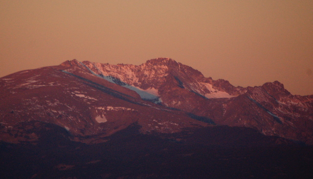
I set out, later than I had planned, but still well before dawn. There was very little traffic as I drove through Longmont, through Boulder, and up Boulder Canyon. The sky began getting light as I entered Nederland, and as I drove up the dirt road to Fourth of July Trailhead I caught fleeting glimpses of South Arapaho Peak's south-east ridge lit by the morning sun.
I parked and headed up the trail at 06:45, into Indian Peaks Wilderness, and past the Fourth of July Mine toward Arapaho Glacier Overlook. I saw Mount Neva at the end of the basin, which I snow-climbed earlier this summer, still sheltering snow in its northern cirque as I climbed above timberline to the glacier overlook.

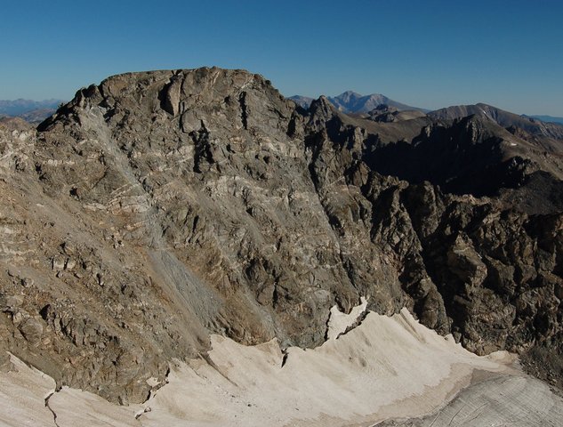
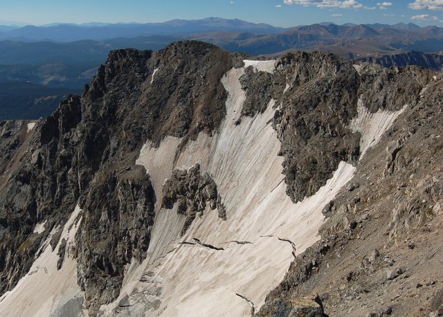
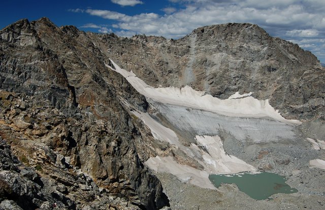
I reached the glacier overlook and peeked over the ridge into the City of Boulder's Arapaho Glacier watershed, allegedly patrolled vigorously by the Boulder Glacier Cops. (At various points during my climb I stopped to face into the watershed and wave at the glacier cops, just in case they were watching me. I did not spot any obvious signs that they actually were.) This late in the year, the glacier was clearly dirty and crevassed. I could see a clear line below which all of this year's snow had melted, leaving only the gray glacial ice below. The tarn below the glacier was a brilliant teal, filled with fine glacial sediment, and the untouched watershed stretched to the east.
I ascended the south-east ridge of South Arapaho Peak, which seemed easier than it was when I climbed the ridge two years ago. I wasn't sure if that was better route-finding skills, better scrambling skills, or if the route was really that much easier two years later. I reached the unranked south summit at 08:45, two hours after leaving the trailhead, and sent a quick text message to Twitter to telegraph my progress so far. I found the summit register but the cap was attached too tightly for me to easily open it with my cold fingers. A brisk wind blew from the west, enough to drive me into my windbreaker, hat, and gloves, but not enough to chill me further.
Armed with my pocket-sized first-edition copy of Gerry Roach's Indian Peaks climbing guidebook, I set out for the north summit via the connecting ridge. I navigated the first of four class-three cruxes easily, then ran into the second tower and eventually located a tiny, well-worn ledge on the west side of the ridge that took me, via a few exposed class-three moves, to the other side. On top I found a woman who had been left behind by her climbing partners; they had ropes to attack the class four moves at the crux of the ridge directly, and she queried me on the route I had found.
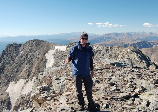
I found the third class-three crux by peering nervously over an overhanging route when the climbers ahead of me shouted to get my attention and directed me to my left, down the ridge a bit to an easier route that didn't involve stepping blindly into the void. I found the right gully to scramble up the last class-three pitch to the summit and, just as reached the summit plateau, found the climbing pair ahead of me already on their way down. They asked me to take a victory portrait on the summit (I framed Mount Neva in the background) and imposed on them to take a victory portrait of me on the summit.
The wind was brisk enough on the summit that I didn't linger very long. I found the summit register on the south side of the giant summit cairn and surveyed the mountains around me: South Arapaho Peak dominated the ridgeline to the south, perched above Arapaho Glacier; further south, I could see more Indian Peaks, James Peak, and a handful of Front Range fourteeners. To the north I could see the conical summit of Navajo Peak and the flat south slope of Apache Peak framing Longs Peak. Mountains stretched off in every distance but east, where the City of Boulder's watershed gave way to foothills and ultimately the City of Boulder itself. I looked for my office and found Boulder Reservoir and figured it couldn't be too far away. From the right vantage point I could see both Eldora and Winter Park at the same time.

I left the summit and began retracing my steps back to South Arapaho Peak and ultimately the trailhead. Most of the route-finding was easier on the way back, because I had already found the route and still remembered most of it. I decided to bypass the exposed ledge I found on the second class-three crux (concluding that caution was the better part of valor on any exposed class-three terrain) by scrambling down the ridge twenty or thirty meters, then scrambling back up the gully on the opposite side. When I returned to South Arapaho Peak, I talked to a few people on the summit and successfully signed the summit register before continuing my descent. A well-trod trail took me straight down the south-west face of the mountain, to the top of one of the formerly-snow-filled couloirs; I had to traverse to the east to reach the ridge again for the proper descent. Upon analyzing my GPS tracks, this seemed to be quite similar to the route I took on my South Arapaho ascent two years ago, but it felt much easier for reasons I still haven't been able to identify.
On my traverse and descent, I invented a new word to describe the irresistible allure of trail markers, even as they threaten to lead one off-course: cairen, a portmanteau of cairn (as in the pile of rocks marking the trail) and siren (as in the mythological creature), which I intend to be pronounced as KAI-ren. I resolved to popularize my new word wherever possible. (Google does not yet recognize cairen as a word, suggesting cairn instead.)
Upon reaching the Arapaho Glacier Overlook, I was ahead of schedule and drawn by "Old Baldy", an unnamed ranked thirteener to the east that seemed a worthy goal for its views of the Arapaho cirque. (Aside from my later-than-scheduled start, this was my one deviation from my new mantra "plan the climb, climb the plan", designed to keep me on-route and on-schedule, which requires as much discipline planning as it does in execution.) I traversed the gentle tundra to the summit and was surprised to find not only two people on the summit but a proper Colorado Mountain Club summit register. The view of the Arapaho Peaks framing the glacier did not disappoint.
I returned to the saddle between South Arapaho Peak and "Old Baldy" thirty-five minutes after diverting for the lower summit and continued my descent into the North Fork Middle Boulder Creek drainage. I returned to the trailhead six hours and forty-five minutes after departing; counting my thirty-five minute detour the scheduled climb took six hours and ten minutes, putting me at the lower end of Dave Cooper's estimate. I stopped for tea in Boulder on my way home and returned victorious, having conquered the highest point in Indian Peaks Wilderness with an exciting and not-too-hard scramble.
