Mount Julian
Started: 2010-08-31 20:21:49
Submitted: 2010-08-31 21:47:05
Visibility: World-readable
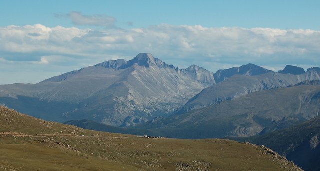
Just because a mountain is easy to see doesn't mean it's easy to reach. Mount Julian towers above the picturesque Gorges Lakes in Rocky Mountain National Park, easily visible from Trail Ridge Road, but the massive glacier-carved Forest Canyon separates the road from the peaks.

The standard route to Mount Julian involves hiking 6.7 miles from Milner Pass along the Continental Divide, climbing up and over Mount Ida, Chief Cheley Peak, Point 12,820, and Cracktop. This was my mission for Saturday, 21 August.
Since most of the hike was above treeline, I wanted to get an early start to minimize my potential exposure to afternoon thunderstorms. I woke up at 04:00, ate breakfast, and drove to my nearest National Park. Driving Trail Ridge Road in the pre-dawn gloom was singular; I could make out the barest outlines of the park's massive mountains and had to fill in the details of Ypsilon Mountain and Mount Julian from memory. I parked at Milner Pass around dawn and hit the trail at 06:30.
The designated trail climbed through the trees to treeline. A sign at the last junction warned about the dangers of navigating above treeline without a trail and without a map, where the slightest deviation from one's assigned bearing can send one down the wrong drainage. Above treeline, the trail was obvious for several miles as it followed the slope below the crest of the Continental Divide. I could see the Never Summer Mountains to the west, the Mummy Range to the north, the Gore Range to the south-west, and the Indian Peaks to the south.

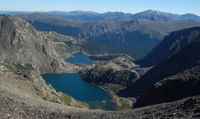
The well-trod social trail gave out a mile from Mount Ida, leaving me to climb easy class 2 tundra with scattered rocks with only the slightest hint of a trail. I reached the summit (12,900 feet; ranked 715 in Colorado and 21 in Rocky Mountain National Park) easily and searched unsuccessfully for a summit register. I could finally see Mount Julian across the cirque, which seemed almost as remote as it did when viewed from Trail Ridge Road, and the summit afforded an interesting view of the Indian Peaks, presenting some interesting juxtapositions when viewed from this unfamiliar angle. (North Arapaho Peak appeared immediately above Fair Glacier, rather than several miles away. I'm used to seeing these mountains in a neat line when viewed from the flat lands of Boulder County, not from the north-west.)
I descended Mount Ida's steep south-east ridge and ascended Chief Cheley Peak's north-west ridge. I reached the summit easily and calibrated my GPS receiver's barometric altimeter for the summit's surveyed elevation of 12,804 feet. (Gerry Roach's list of the national park's summits listed the unnamed Point 12,820 as the ranked parent of both Chief Cheley Peak and Cracktop, and I was curious whether it was in fact higher, since both Chief Cheley Peak and Point 12,820 mustered only a single closed contour at 12,800 feet. All of this chatter about ranking and parents and topographic prominence may seem a bit technical but it gives me the opportunity to obsess over something while climbing.) I traversed the ridge to Point 12,820 and checked my GPS receiver's elevation reading and saw that it reported about 12,835 feet, suggesting it was, in fact, the legitimate parent of Chief Cheley Peak.

I continued to Cracktop, found only a few pieces of broken glass that I assumed must have been a summit register years ago, and contemplated Mount Julian, my final (and highest) destination for the ridge-hop. On the map it was a modest half-mile, but that half-mile involved descending 350 feet of class 3 terrain on the narrow ridge. It was here that my hike turned into a climb, and the best-guess schedule I had laid out for myself disappeared. I descended a bit too far to the south-east of the ridge and kept having to traverse vertical spines of rock before I decided I ought to climb back toward the crest of the ridge, which proved the best choice, as the scrambling soon eased. The half-mile ridge taxed my route-finding skills, which seemed to have a built-in disadvantage that I could only see the mountain immediately in front of me and had to guess whether the rock was passable without exceeding class 3. I did, at least, get a little better guessing whether a particular move on a particular rock would be class 3.
I reached the saddle between Cracktop and Mount Julian and began the final push to the summit. The ridge was blocky and scrambling up the car-sized boulders was much easier than the descent from Cracktop. I reached the summit of Mount Julian (12,928 feet; ranked 697 in Colorado and 19 in the national park) at 11:30.
I scanned the western sky for signs of storms and found nothing. I signed the official Colorado Mountain Club summit register, which had been placed in 2004 and averaged about a dozen signatures per year. The last signatures in ink were last year; I saw three scratched lines that looked like an attempt to leave a mark with a stylus when the pen was gone. I donated my pen to the summit register after signing.
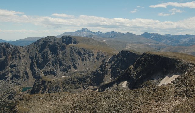
I ate lunch and contemplated my return. Across the cirque I could see people standing on Mount Ida, and a few figures moving on Chief Cheley Peak and Point 12,820.
I began retracing my steps back to the trailhead by descending the blocky south ridge of Mount Julian, then began the scramble back to Cracktop. I had just enough of an idea where I was going to stay mostly on-route, but the scramble was still long and the route-finding tricky. (It was still easier than the final scramble up McHenrys Peak from Stone Man Pass.) On the summit of Cracktop I contemplated dropping into the upper reaches of the cirque, crossing the terminal moraine anchoring the tarn Highest Lake to the hillside, and scrambling up the opposite side of the cirque, bypassing Point 12,820 and Chief Cheley Peak and the elevation gain that would entail. I studied my map and surveyed the terrain carefully and decided I would give it a shot. Dropping into the cirque and crossing the moraine went well, but once I got below Chief Cheley Peak I could see that I had misread my map and the terrain and missed the snowfield separating me from the saddle between Chief Cheley Peak and Mount Ida. I did not bring the appropriate gear to cross the snowfield, so I scrambled down the side of the snowfield, crossed below it, and scrambled up the opposite side to the saddle. The difficulty never exceeded class 2, but the elevation I lost and had to regain was more than I would have had to climb had I stuck to the ridge. My shortcut was really nothing of the sort.

From the saddle, I had to climb another 400 vertical feet to the summit of Mount Ida before I could continue my descent to the trailhead. The wind picked up as I crested the saddle and kept blowing as I ascended. I was tired and hungry and tried to maintain my blood sugar as I climbed, wary of calorie crash five miles from the trailhead.
I reached Mount Ida for the second time and looked back on Mount Julian, towering above the lakes in the cirque, and knew I had accomplished something.

The rest of the slog back to the trailhead was long and uneventful. The mid-afternoon light was different than it had been in the morning; the eastern sides of the mountains began to fall into shadows as the western sides lit up. (In most of the Front Range, the eastern sides of the mountains were carved by glaciers while the western sides of the mountains are broad expanses of tundra, leaving the eastern sides more photogenic and clearly favoring the early-to-bed, early-to-rise photography crowd.)
I reached Milner Pass at 16:15, ten hours after setting out, having blown out my optimistic schedule. I still needed to check in with Kiesa to let her know I was off the mountain; I gave her an absolute deadline of 17:00, though I suggested I'd be done before then. (My earlier estimate was based on hiking the entire distance to Mount Julian, rather than the more realistic scrambling, which ate up far more time than I had budgeted. I keep wanting to put together a comprehensive schedule-estimation toolset, based on my actual hikes and taking into account terrain, distance, and elevation gained and lost, but I haven't yet taken the time to do so.) I headed east on Trail Ridge Road, spotted Mount Julian from the road, tried not to get too angry at the slow-moving tourist traffic on the two-lane road, and made it to the wi-fi connection at the Beaver Meadows Visitor's Center with mere minutes to spare before my deadline. I Twittered my presence and continued into Estes Park and home.