McHenrys Peak
Started: 2010-08-19 19:51:06
Submitted: 2010-08-19 21:05:34
Visibility: World-readable
As June gave way to July, I carefully considered my snow-climbing options and decided I didn't have many. The Glacier Gorge couloir between Chiefs Head Peak and Pagoda Mountain looked attractive, but the wet spring gave way to a warm summer and melted away even the early-June snow faster than I expected. A week after climbing Apache Peak, I discovered that I could sustain major expeditions only once every other weekend and went hiking to Lake Hiyatha at the mouth of Chaos Canyon from Bear Lake in Rocky Mountain National Park. (Anything involving Calvin, it turns out, is a major expedition in itself, and it didn't help that the park-and-ride lot was totally full, forcing us to backtrack to the Moraine Park Museum to catch a shuttle to the park-and-ride, then another shuttle to Bear Lake itself. Calvin enjoyed the hike but wasn't especially thrilled by not having a large flat space to run around on at the end of the hike. From the trail below Dream Lake I had an excellent view of Longs Peak and Pagoda Mountain from the Colorado state quarter, and saw that the snow reached only half-way up the couloir I had considered climbing that day.)
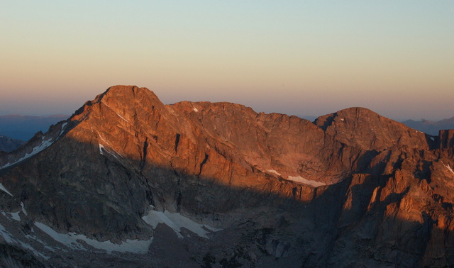
The following weekend, I set my sights on McHenrys Peak, proudly visible across Glacier Gorge from Longs Peak. (I took the picture above from the Keyhole while climbing Longs Peak two years ago.) I got up early on Saturday morning, ate breakfast in the dark, and drove to Estes Park. On the way I encountered a moose buck sauntering across the highway in the pre-dawn gloom and managed to give it a sufficient berth as I passed. Cloudy skies kept me from seeing the sunrise as I drove through an abandoned Estes Park and entered the National Park. I got one of the last spots in the parking lot at the Glacier Gorge Trailhead and saw a group assembling ahead of me. They hit the trail before I did, and I passed them on the climber's shortcut trail cutting off Alberta Falls and learned that they were headed for Thatchtop, an appropriately-named mountain that looks like nothing so much as a thatched roof.
I paid too much attention to the map on my GPS receiver and not enough attention to the trail as I navigated the final five-way junction and thought I had taken the turn toward Loch Vale rather than Glacier Gorge. I hadn't, but I still backtracked to the junction to verify I was on the right track. As I hiked up Glacier Gorge, the clouds persisted but for scattered glimpses of Chiefs Head Peak, bathed in early-morning light, through the clouds and the trees. I reached Black Lake at the end of the maintained trail and broke through the clouds to see McHenrys Peak towering majestically above the lake.
I followed an unmaintained trail up the gully to the east of the lake and broke out into a broad basin at the end of Glacier Gorge, surrounded by mountains: the broad, talus-covered west slope of Longs Peak stood to the east, crowned by Keyhole Ridge and The Trough; Keyboard of the Winds marked the ridge to Pagoda Mountain; Chiefs Head Peak stood mostly hidden behind the rounded granite obelisk The Spearhead; the Stone Man (looking very much like a man made out of stone) stood guarding Stone Man Pass; and McHenrys Peak, the lowest of the four surrounding summits, stood overlooked by most but me. I could see a few dozen technical climbers making their way up The Spearhead in various parties on various routes, but the rest of my route was deserted. To the north I saw clouds covering the lower expanse of Glacier Gorge up to the Mummy Range miles to the north.
I picked my way across the basin to the west, trying to find a reasonable route to Stone Man Pass. I ended up visiting tiny Frozen Lake, nestled below The Spearhead and looking quite liquid, and scrambling over the rocks on the west side of the lake to a massive expanse of gently-sloping granite. I followed the direct route to Stone Man Pass a bit too literally, and ended up with climb class four cliffs between me and the pass. I backtracked, found a better route to the gully leading north to the pass, and snow-climbed up a hundred vertical feet of soft summer snow to the pass itself.
On the crest of the pass I took a short break and surveyed my surroundings: the broken north face of Mount Alice was now exposed to the south, and I could see west down trailless valleys into untracked wilderness toward Grand Lake. I studied the route description in the pocket-sized Gerry Roach guidebook I brought with me and wondered exactly how many of Rocky Mountain National Park's mountains this library guidebook had ascended.
I began climbing north-east, along the class two talus that quickly gave way to class three scrambling. I had trouble route-finding up what I took to be the gully leading me to the tiny notch marking the crux of the route, finding cliffs larger than I was willing to climb this far from civilization. Much of the scrambling itself was fun, but the route-finding taxed my route-finding skills more than I expected.
At length, I crested the ridge, scrambled the last few feet to the summit, and found the large rock marking the summit. The summit push had worn me down, and the large cliff marking the east face, less than two meters from the summit rock, unnerved me. I found and signed the summit register and saw that the last person on the summit had ascended a week ago, and the log had less than ten entries this year. The log went back several years, at least to 2006. I might not be as high as Longs Peak but I was on far more rarefied ground.
I ate a large pre-lunch snack and began my descent. Picking my way down the class three summit ridge proved just as technically demanding as the ascent; having gravity on my side meant I needed to be even more cautious about where I stepped. Back at Stone Man Pass I donned crampons and deployed my ice axe for a careful descent of the snowfield that afforded the most obvious descent route. The top several inches of snow were soft in the summer heat, but the rest of the snow was hard-packed. Halfway down the first bit of snow I slipped and began sliding, feet-first, down the slope. I hadn't actually practiced self-arrest, but I knew what I was supposed to do: rotate into the snow and dig the pick of my ice axe into the snow, using the friction to stop my slide. I flipped halfway, unwilling to loose my view of where I was going, and came to a gentle rest on a rock at the base of the snow field.
I took a few minutes to regain composure and began picking my way down the wet scree separating two snow fields. I kept my crampons on because I knew I'd need them again, and dislodged a modest rockfall that tumbled down out of view, descending the gully in front of me. I didn't think anyone else was in the gully, or anywhere near Stone Man Pass, but I didn't want to be mistaken. Still unnerved from my slide, I shouted "Rock!" until the slide stopped, hoping to alert anyone who might be under my rock fall to watch their surroundings.
I continued down the gully and adopted a self-belay stance to down-climb the next snowfield, then picked my way to the talus on the opposite side. I shed my crampons, relieved to put the gully behind me and instead have a freeway of stable car-sized boulders to navigate. The only remaining navigational hazards were the creek draining Frozen Lake and an expanse of willows below The Spearhead, which were easily crossed once I found the path. I saw where the rough path crossing the lower portion of the basin met the well-traveled path I had followed on my way up, and joined the track to descend to Black Lake.
I stopped for lunch on a broad rock halfway down the final gully to Black Lake, once I was confident I was well-protected against any afternoon thunderstorms. The risk of rain proved hypothetical; the rest of the day remained clear and bright as I descended the long slog back to Glacier Gorge Trailhead and my car. Mine were some of the many tired feet returning to the trailhead, having successfully climbed my mountain.
Back at the trailhead, I noticed a dog locked in the car parked next to me, and brought it to the attention of the parking lot attendant who kept the shuttle busses running and generally gave directions. He said he'd keep an eye on the dog and bring it to the attention of the park rangers if conditions merited. The windows were cracked and the dog did have food and water, but it was a hot bright day and I still wasn't sure it was entirely appropriate.
Many of the guidebooks (and guidewebsites) I consulted suggested that McHenrys Peak might be harder than Longs Peak, and I'm inclined to agree. In terms of elevation and length, Longs Peak wins, but even the class-three pitches on Longs are well-marked and well-traveled. The class-three climbing on McHenrys was high and long and required extensive route-finding. Even the cross-country basin travel from one side of Glacier Gorge to the other needed more route-finding than I expected. McHenrys was a fantastic climb and a worthy way to spend my Saturday.
