Kings Peak
Started: 2011-08-16 08:09:48
Submitted: 2011-08-21 17:40:56
Visibility: World-readable
In 2008, while climbing Mount Adams (the stratovolcano in Washington), Willy and I talked each other into climbing the high points of the eleven contiguous western states. We didn't manage to climb any of these summits for nearly two years; we climbed Mount Elbert last year, and set our sights on Utah's Kings Peak this year. Willy made a leisurely drive from Washington to Alabama to begin his second year of graduate school, and we compared schedules to figure out what would work for both of us. I was initially unsure how much of my vacation time I wanted to use; I spent the first half of the year carefully hoarding my vacation time and used only 1.5 days of the 7.5 days I accumulated. I eventually realized that the reason I was carefully hoarding my vacation time was so I could spend it on hiking and climbing in the summer -- it's much easier to hike in August than it is in February.
Thursday, 4 August 2011
I took Thursday and Friday off and drove to Lyman, Wyoming. (The fourth of August is a doubly-auspicious anniversary: I've been married to Kiesa for nine years, and working at my current employer for three years. I celebrated by spending the day driving.) While I drove up US 287 to Laramie and turned west on I-80, I listened to the audiobook version of The Boys of Everest: Chris Bonington and the Tragedy of Climbing's Greatest Generation by Clint Willis, which told of the British climbers who remade climbing and pioneered new direct technical routes on mountains that had already been climbed. Many of the direct-aid techniques seemed archaic by modern sport-climbing aesthetics, but I understood enough of the sport of climbing to get a good idea what these climbers went through. I couldn't help but be inspired by their adventures even as I understood what it cost them.
I stopped for gas in Rock Springs, Wyoming, and saw that the stock markets were falling. (I was in civilization earlier in the week to watch Washington narrowly avert a default (but still failed to address the twin underlying problems of partisan gridlock and unfunded entitlements), but I missed two chaotic days of economic news while camping: S&P downgraded the credit rating of the United States while I was setting up camp deep in the wilderness on Friday afternoon.) I continued west to Lyman, Wyoming, where I located the public library and waited for Willy to arrive. My drive had taken six hours with only two short stops; I arrived at 15:00. I checked my e-mail on my phone (proving that civilization had in fact survived the stock market plunge), consulted my guidebook and maps, and read a book about Tibet. Willy arrived at 17:00, having driven south through Yellowstone.
I took the lead and we drove south, away from the interstate, toward the High Uintas Mountains. We could see the mountains on the horizon, and as we headed south on a succession of dirt roads through rolling hills covered in bright-green scrub surrounding lush valleys I realized that this part of Wyoming was more scenic than was obvious from the interstate. (It seemed, in fact, that the Wyoming Department of Transportation had intentionally routed I-80 through the least-scenic part of the valley so no one would be compelled to stay.)
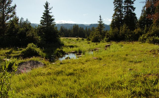
We reached the Henrys Fork Trailhead after an hour of driving at the tail end of a rain storm. I surveyed the trailhead, which seemed to be packed with vehicles but otherwise devoid of people. There were a couple of designated camp sites at the trailhead; I claimed one and set about boiling water in the waning rain to make supper. (I picked up freeze-dried, no-cooking-required backpacking meals for my three suppers, including the car-camping night.) I pitched my tent (on the assumption that my three-man tent would fit two men better than Willy's two-man tent) and we settled in for the night.
Friday, 5 August 2011
After my experience climbing Mount St. Helens, and missing my check-in time, I knew I needed to come up with a better scheme for reassuring Kiesa that I was in fact alive, while maintaining enough flexibility to deal with unforeseen circumstances as they arose. My new satellite personal locator beacon includes a self-test feature that sends my beacon's unique id to the satellite with a specific non-emergency code. I signed up for a service that listens to those non-emergency messages and sends e-mails and text messages when I self-test the beacon. I set up a system of check-in events tied to particular milestone events so Kiesa would know roughly where I was. When Willy and I set out on the trail on Friday morning, I sent a self-test message so Kiesa knew we were on the trail. When we reached our camp site on Friday afternoon, I sent a self-test with GPS so Kiesa knew exactly where we were camping. I had no other capability to reassure Kiesa that I was where I planned to be, especially on a multi-day backpacking expedition, since my cell phone lost coverage about the time I pulled out of Lyman. (I'm now lusting after a two-way satellite pager but I'm pretty sure I'll be able to resist that urge for now.)
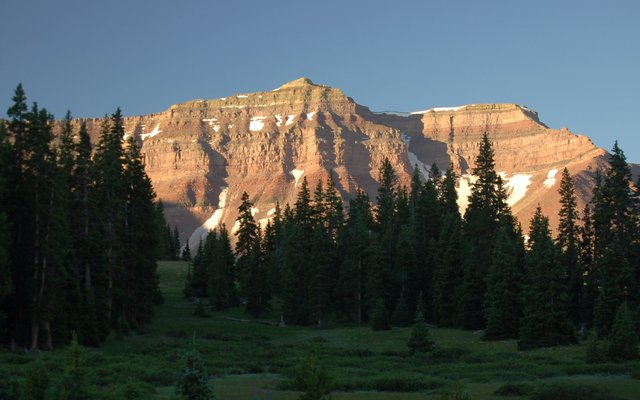
Willy and I broke camp, ate breakfast, loaded our packs, and headed south up the Henrys Fork Trail along the Henrys Fork River. This was the shortest route to Kings Peak (for definitions of 'short' that include 'twenty-four miles round-trip') so it was relatively well-used, as wildernesses in Utah go. (My scale for "well-used wilderness" is calibrated to the vicinity of Brainard and Bear Lakes, which are essentially overwhelmed by people on any average weekend. I saw plenty of people in the Henrys Fork Basin but nowhere near as many as I would see in the Front Range's overused wildernesses.) We hiked seven miles up the river into the upper (southern) portion of the river drainage, where the basin opened up into a large meadow with occasional strands of trees. We could see the surrounding peaks, which were comprised principally of flat strata of sedimentary rocks in varying levels of strength. The meadows around treeline reminded me of Colorado's mountain meadows but the rock and mountains themselves were unmistakably Utah.

We spotted a large flock of sheep grazing in the meadow, which seemed strangely incongruous with the wilderness ethos, though the sheep were technically non-mechanized, as were the ranchers who tended them on horseback. When I consulted my guidebook that night I learned that the wilderness was the site of a number of grazing permits.

By mid-afternoon, we reached the vicinity of our proximate goal for the day. We left the trail in the vicinity of Dollar Lake, which provided the last good campsites below timberline along the direct route to Kings Peak. I spotted a smoldering unattended campfire, putting off a fair amount of smoke, and headed toward the nearby campsite to see if anyone was there who was willing to take ownership of their campfire. I found an early teen boy who mumbled something about leaving the fire until they restarted it that night, and tried to impress on him the importance of not ignoring it entirely, lest it get out of control.
We dropped our packs next to Dollar Lake and scouted campsites on the north-west side of the lake. I found what looked like a good site, far enough from the lake to be acceptable but not far enough that it escaped the lake's thousand-foot campfire exclusion zone, imposed by the Forest Service to avoid wilderness overuse. (I thought it might be barely visible, through the trees, from the trail, but I wasn't quite sure.) We set up camp and I used my emergency beacon to send a self-test with a GPS fix, which told Kiesa that I'd reached camp and gave her the precise location of my camp. We ate supper just as the mosquitos came out in force; neither of us had remembered to bring bug repellent, so we swatted and retreated to the safety of the tent as soon as we were finished eating. I stashed my food in my bear canister a safe distance from the tent, and Willy slung his over a tree. I consulted my guidebook, Utah Thirteeners: A Guide to climbing the 13,000 foot peaks of the High Uintas, by David Rose, for more information on the next day's summit push and general information on the area, the wilderness, and its geology.

Saturday, 6 August 2011
By pure coincidence, our Willy and I planned to summit our second western state highpoint exactly one year to the day after our first. After eating breakfast and pumping water, we set out for our ten-mile summit push. We rejoined the main trail leading south through the lush tundra just above treeline in Henrys Fork Basin to Gunsight Pass. We stopped to snack at the pass, then took the social trail my guidebook described as the "Gunsight Cutoff", contouring south-west from Gunsight Pass toward Anderson Pass and Kings Peak. The trail crossed a snowfield, suggesting that Utah shared Colorado's epic spring snows, and disappeared on the shoulder of the unnamed peak west of Gunsight Pass, which my guidebook author designated "Dome Peak". When the trail gave out, we were perched on a gentle grassy slope high above Painter Basin, with a great view of the north ridge and north-east slope of Kings Peak. (Last winter I spent several weeks studying topographic maps of the area and tracing the trails in the general vicinity of Kings Peak, so although I was seeing the topography for the first time it was all familiar.) I could see Anderson Pass to the west and headed toward it across gentle slopes with broken talus. I knew there was supposed to be a trail heading up to Anderson Pass but I wasn't sure where it was, and I wasn't sure it was worth trying to find. As we approached the second pass I turned south, to attack the final nine hundred vertical feet. The ridge climbed sharply, and we struggled to keep up on the broken talus. We found the social trail up the ridge, which came and went as the ridge ascended. As we climbed through 13,000 feet I noted I was higher than I'd climbed all year long. (Willy passed his high point below camp, below 10,000 feet.)
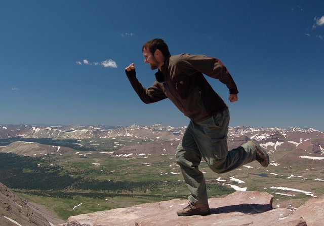
We reached the summit of Kings Peak, the highest point in Utah, just after noon local time. I exclaimed "Berg heil!" as we summited, catching the attention of a group of young Europeans who reached the summit at the same time we did. We took pictures (I adopted the mantel of the official expedition photographer when Willy's camera apparently died) and ate lunch. I got my first good look at the basin to the west, draining to the south in the narrow valley carved by the Yellowstone River. I could barely make out the Henrys Fork Basin to the north; our campsite along Dollar Lake was obscured by the crest of the Uinta divide.

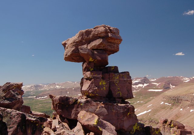
We departed the peak and began picking our way down the talus toward Anderson Pass. Route-finding was never difficult but we did have to trace an appropriate route through the appliance-sized boulders and step carefully to avoid disrupting the rocks. I spotted a precarious two-meter tower on the crest of the ridge that looked like a cairn built out of rocks too large to easily lift.
We bypassed Anderson Pass to the east and followed the now-obvious trail east from the pass into Painter Basin. Unlike the lush tundra on lower elevations in the surrounding basins, the relatively flat terrain here was rocky and drier, with more lichen than actual vegetation. We left the trail to hit the Gunsight Cutoff, found a giant cairn on the shoulder of "Dome Peak", and followed the faint route to contour north-east around the mountain, eventually finding the social trail we used earlier.

We reached Gunsight Pass and continued north into Henrys Fork Basin, retracing our steps back to camp. I ran out of water on Gunsight Pass (I awkwardly lashed the two-liter Camelbak bladder to the slim daypack that doubled as the top of my backpacking pack, and also carried a liter of Gatorade) and wasn't able to rehydrate until we returned to camp. My water filter began to show signs of clogging, forcing me to take time to take it apart and scour away the outer surface of the ceramic filter element before we could drink. (I made sure to clean my filter before leaving home, but it clogged far more quickly than I expected.) I failed to eat adequately on the second half of the hike; after lunch on the summit I didn't eat anything else for several hours. This, combined with my hike-induced dehydration, conspired to make me feel weak and nauseated; I felt worse after resting for the second half of the afternoon than I did upon returning to camp. I eventually realized that I needed to rehydrate and eat, carefully; as Willy was preparing for supper I raided my last stockpile of powered Gatorade and made another liter. I drank it slowly, and didn't manage to keep it all down, but I eventually felt well enough to trudge around outside to make my supper. By that time it was evening, and the mosquitos were out in force; I barely managed to finish cooking before I retreated to the mosquito-free sanctuary of my tent to eat supper, despite violating wildlife food-handling precautions. (Mosquitos eating my blood is unpleasant, but I drew the line at their flying into my food and dying, forcing me to pick them out of my bowl lest I eat them.) I didn't manage to finish my supper but I did manage to consume enough calories that I was confident I could actually hike out the next day.
Sunday, 7 August 2011
I felt fine when I woke up on Sunday morning. Mosquitos forced Willy and I into the tent to eat breakfast. We broke camp, packed our backpacks, and headed down the trail at 10:00, retracing our steps down the Henrys Fork River to the trailhead. We didn't see many people at first but saw more people as we approached the trailhead. We emerged from the wilderness and reached the trailhead at 13:00, having covered seven miles in three hours. The parking lot was far emptier than it had been when we arrived, possibly due to the departure of the maximum-sized, 14-person Boy Scout group that we encountered on the trail on Friday morning. (The information board at the trailhead included the wilderness regulations, including the maximum size of groups (fourteen people), and specifically explained this regulation included Boy Scouts.) We packed our gear into our respective cars and Willy followed me back to Mountain View, Wyoming. Willy and I parted ways once we reached civilization; he wanted to spend another day camping near Dinosaur National Monument before stopping by my house, and I wanted to drive home. I stopped in Mountain View to call Kiesa and let the rest of the world know I had survived my first backpacking trip in three years. (I also needed reassurance that, after the market rout on Thursday, civilization as I knew it still existed. I didn't yet know about the S&P downgrade.)
I drove east on I-80, stopping only briefly, confident that I had enough time to get home at a reasonable hour. I stopped for supper at Chipotle in Fort Collins and marveled at the novel prospect of eating indoors after three nights of camping. I returned home a little after 20:00, with plenty of time to shower and unpack and sleep before heading to work the next morning.
