Moving pieces
Started: 2010-08-16 20:08:34
Submitted: 2010-08-16 21:38:54
Visibility: World-readable
My original nuclear family visited in early August, and it took careful planning to get all the moving pieces to work together.
After spending an academic year in India, Willy returned to North America in June and settled into Walla Walla. He and my mother drove to my parents' timeshare at Powderhorn, on the north slope of the Grand Mesa in western Colorado. They picked up my father at the airport in Grand Junction, flying in from his summer job in Sacramento. Willy's car was packed with his stuff to move to graduate school, so he didn't have space to carry both parents to the front range for the weekend. I came to the rescue, driving to western Colorado on Thursday and taking Willy back with me on Friday, by way of Mount Elbert, the twenty-seventh highest mountain in North America, the fourteenth most-prominent mountain in the United States, and (more importantly) the highest mountain in Colorado. (Sometime during our expedition to Mount Adams on Cascade Volcano Day two years ago, Willy talked me into joining him to climb the eleven state highpoints of the contiguous western states, which seemed like a reasonable idea because the summit afforded us a singular view of two of the northwest's state highpoints.) This gave Bethany a good opportunity to actually see the entire family in one place, so she flew out from New York for the weekend.
Thursday
Kiesa and I went out for dinner at Leaf on our eighth wedding anniversary on Wednesday evening. My alarm woke me up at 07:00 on Thursday, giving me plenty of time to run five miles, eat breakfast, and stop for coffee on my way out of Longmont. I drove down I-25 to I-76 to I-70 for the long slog across Colorado, climbing to the Eisenhower Tunnel and again to Vail Pass, then passing all of the interesting parts of Colorado (at least, for those interested in mountains, which has been my emphasis of late) for the flatter and hotter western slope. Along the way I listened to the audiobook of Salman Rushdie's Midnight's Children, which was a fascinating bit of magical realism and would have been totally inscrutable if I hadn't known as much as I learned in the past year about Indian history. (It occurs to me that more time has elapsed since my return from India -- five months -- than elapsed from my first getting the idea to visit to my actual trip -- four months -- and I'm still working through my backlog of reading material.)
This being the first time I had seen Willy since catching an auto rickshaw from the main street in Siliguri to the airport at Bagdogra, I finally got the opportunity to see the pictures he took while we were in Darjeeling, which gave a different perspective on the whole thing. (He also mentioned that he recalled our tea shopping on an entirely different evening, and I'm inclined to believe he's probably right, given that he wrote his account before I wrote my account. However, I assert that despite lacking literal truth, my account is still sufficiently figuratively truthful.)
I did not manage to get to bed very early, despite my declared intention to wake up at 04:00.
Friday
My alarm went off, entirely too early, at 04:00. I joined Willy for breakfast and we carried the rest of our stuff out to Yoda and departed at 04:45, still well before dawn. The sun rose about the time we stopped for gas in Glenwood Springs, affording a great early-morning view of Glenwood Canyon. We continued east and turned off I-70 at Minturn, heading up US 24 toward Tennessee Pass. I pointed out Eagle Park and the site of Camp Hale in the early morning light and pulled off to let Willy look at the interpretive signs. (Despite living in Colorado for thirteen years, he never made it to Camp Hale. I didn't make the visit myself until last year. The site of the Tenth Mountain Division's Second World War training camp is now mostly empty fields, with scattered foundations and ruins, and is steeped in more history than is readily apparent from a casual observation.) We stopped again at the monument at the top of Tennessee Pass, then continued south into the Arkansas River Valley, through Leadville, to the North Elbert Trailhead nestled between Mount Elbert and Colorado's second-highest peak (by normal Colorado prominence standards), Mount Massive. We had driven more than three hours to the trailhead, just as far as the drive from home, but I at least managed to pick up a climbing partner.
The trailhead was comfortably full at 08:45 as we hit the trail, a little later than I had hoped but not too far behind schedule. The trail climbed steadily through forested hillside and we used the altimeter on my GPS receiver to note when we climbed through Mount Hood's elevation. We crossed timberline and continued the long slog up the trail climbing steeply up the mountain's north-east ridge. We had a great view of Leadville to the north-east, and Mount Massive immediately to the north. Most groups had gotten an earlier start than we had, but we passed many of them on the mountain as we climbed.
At 13,441 feet, I climbed past the elevation of Apache Peak, my prior highpoint so far this year. (We passed Willy's highpoint in the vicinity of the trailhead. I was a little worried how well he would do at elevation but managed to set a pace sufficiently ambitious to reach the summit in optimal time without going too fast.) Around 14,000 feet, the ridge grew more gentle to climb the last four hundred vertical feet, and I started calling off elevations of famous Fourteeners: Pikes Peak, Longs Peak, Mount Evans (Willy's prior highpoint), and Mount Harvard (my prior highpoint). Then, suddenly, we were on the summit: a broad rocky expanse with a modest crowd and an expansive view.
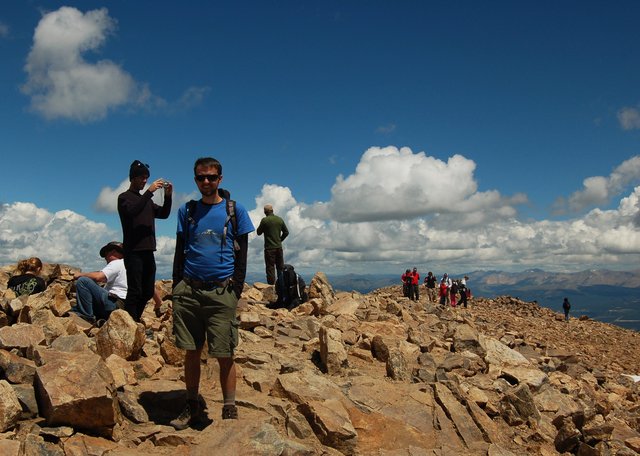
Maintaining any sort of summit register on Colorado's highest summit was an exercise in futility; there were more people within two meters of me as I scribbled my name on a scrap of paper in the summit register than would visit McHenrys Peak (my last major summit) all year.
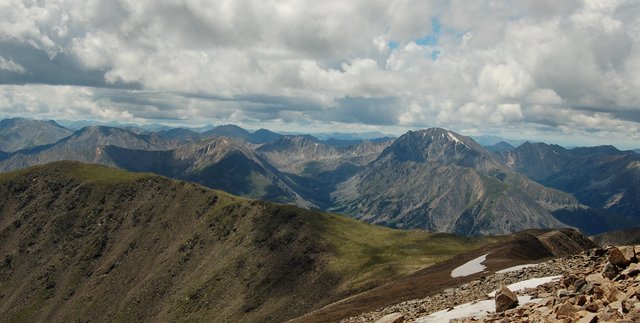
Mountains surrounded us in every direction: the Sawatch Range stretched north and south, with Mount Massive hulking to the north and LaPlata Peak visible to the south. I couldn't begin to identify all the mountains I saw, but I did take the opportunity to point out Mount Oklahoma, a centennial thirteener on the Continental divide.
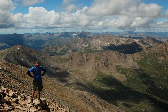
We arrived at the summit at 11:45, after three hours of climbing 4500 vertical feet in 4.5 miles, and spent about half an hour on the summit. I kept a weather eye on the western horizon: the forecast called for a good chance of rain, and I expected the scattered clouds to turn to rain at some point during the afternoon I didn't expect them to start dumping immediately. I was less worried about getting stuck in the rain above timberline on Mount Elbert than on many other mountains I've climbed recently, but I still didn't expect it to be entirely pleasant. We started our descent and I found the descent to be only modestly easier than the ascent; I still had to step carefully, and I had left my trekking poles in the trunk.
As we descended the last five hundred vertical feet to timberline, I kept glancing back over my shoulder at the horizon expecting rain to start at any moment. I knew there were many people behind us on the mountain, and I couldn't help but wonder how many of them knew what they were getting themselves into. Did I have any responsibility to suggest that lingering above timberline after noon on a cloudy day was courting disaster? Most of the people I saw were adults, theoretically capable of making their own decisions -- until we spotted a family of four, with a preschooler and a toddler, on the trail just below timberline minutes before it started to rain. Willy and I stopped to pull on our rain gear, and though we kept up a brisk pace all the way down the trail, the mother kept up with us -- with her toddler son on her back, without a backpack -- for the next two miles back to the trailhead. I was impressed, and couldn't help but think of a mother bear protecting her cubs.
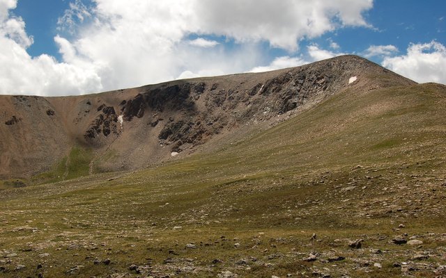
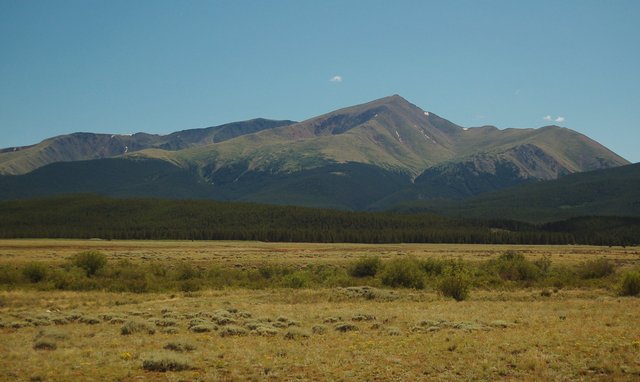
We reached the trailhead, after a long slog downhill in various stages of rain, by mid-afternoon, still roughly on schedule. We drove back toward Leadville and stopped to photograph the mountain we had just climbed -- Colorado's highest summit, and the second-highest mountain in the lower forty-eight.
We'd successfully summited one of the eleven contiguous western state highpoints, leaving another ten to go.
