Andrews Glacier
Started: 2010-07-14 21:03:48
Submitted: 2010-07-14 21:59:33
Visibility: World-readable
One feature of my current obsession with mountaineering is that hikes I'd previously regarded as fine destinations have been relegated to the approach: the necessary evil that takes me to the point where the fun begins. My second snow climb of the season continued this trend, though it had been fourteen years since I visited Andrews Glacier. (I recall hiking from Glacier Gorge to the glacier in the summer of 1996 with my father and another guy he knew. I'm trying to resist the urge to run downstairs and dig around the boxes in the basement to find my physical journal volume covering July and August 1996 in hopes that I'd find some reference to the hike.)
My mission for Saturday morning, 26 July was to snow-climb Andrews Glacier, then walk along the divide to the nearby peaks. It turned out there was a partial lunar eclipse, partially visible at moonset, that morning, but when I looked out the window upon waking up I saw only clouds where I hoped to see an eclipsed setting moon. I drove through Estes Park to Rocky Mountain National Park and watched the SUV in front of me take the last space in the parking lot at the Glacier Gorge Trailhead at 06:45. I continued on to Bear Lake and found plenty of space there, despite adding half a mile to my hike in each direction.
I set out at 07:00 and hiked most of the way back to the Glacier Gorge Trailhead, then passed the early-morning tourists at Alberta Falls and continued west. I passed Loch Vale and turned off the main trail to climb to Andrews Tarn. As I climbed the narrow canyon, my new GPS receiver started drifting; it showed me on the opposite side of the canyon and eventually asserted my position was several hundred meters north-west, overlooking Andrews Tarn, rather than approaching the side canyon known as "The Gash". I turned off WAAS and power-cycled my receiver and, once it regained its position, seemed to have a much more reasonable idea about where I was. This was my first major expedition with my new Garmin eTrex Vista HCx, and I was a little worried about the receiver when it misreported my position, but it didn't give me any more trouble. I took the experience as a reminder to not put too much trust in my fallible technology.
I lost the trail in a patch of snow at the bottom of the canyon and ended up approaching the snow-covered headwall below Andrews Tarn head-on. I deployed my ice ax but was still a little worried by the steep rocky slope below the snow.
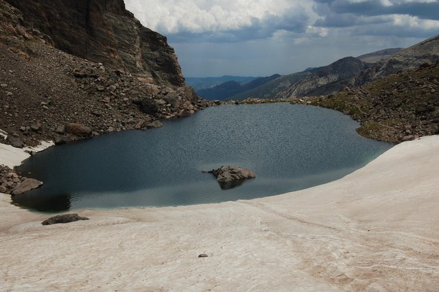
I reached Andrews Tarn, perched above the valley between the remains of the glacier that carved the canyon and its last terminal moraine. From the right angle, it looked like the rocky strip keeping the tarn on the mountainside was paper-thin and ethereal, more magical than physical.
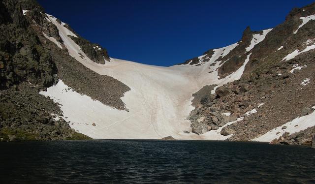
I walked around the south side of the tarn to the glacier, where I donned my crampons and hefted my ice ax and headed up the moderate snow slope. At the end of June, packed snow dominated. I didn't really need my crampons but I liked the extra purchase they afforded on the slope. After climbing Juliet, Andrews Glacier was tame by comparison, but it at least provided a pleasant moderate climb.
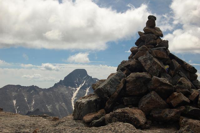
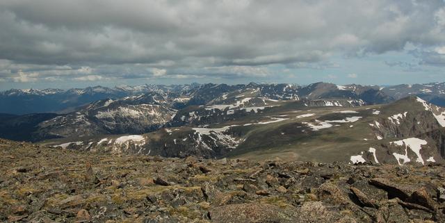
I crested the divide, stowed my crampons, and headed south along the ridge to Taylor Peak, another thousand vertical feet along gentle class two talus and tundra. I could see the Never Summer Mountains and more mountains covered with melting snow than I could identify. I reached the summit of Taylor Peak (13,153 feet above sea level, my highest point so far this summer) and immediately saw an impressive view of Longs Peak from the west, with snow filling the trough most of the way to Black Lake.
I saw mountains everywhere I looked, some of which I've climbed, some of which I want to climb, and some of which I couldn't even identify by name.
I signed the summit register, descended to Andrews Glacier, and thought about caching my pack to climb Otis Peak but decided against letting the overly-friendly local marmot rummage around my pack and left two bottles of water instead. I ascended the ridge to Otis Peak (12,486 feet), signed the register, and descended as ominous clouds rolled in from the west. I strapped on my crampons to descend Andrews Glacier, not feeling sufficiently confident in my snow-legs to attempt a glissade.
I felt a bit of rain as I descended the glacier, but it didn't start hailing in earnest until after I picked my way down the snow-covered headwall under the tarn (which turned out to be steeper than the glacier itself) and worked my way down the rough trail heading down the valley. I passed two outclassed hikers unprepared for the challenges presented by the snow just before the hail descended, gradually changing to rain. I kept my climbing helmet on and pulled my windbreaker's hood above the helmet to protect me from the storm.
I followed the trail back down the valley and started shedding layers as I descended, once the storm passed and left a bright summer afternoon. I found the climber's shortcut trail cutting around the Glacier Knobs, which I discovered was marked on the map on my GPS receiver. I trudged back to my car, happy to have accomplished my major objectives. I stopped for coffee in Estes Park to rejuvenate me for the drive home, and took advantage of the civilized wireless coverage to let the rest of the world know I was back.
The peaks' separation from civilization is what makes them so special. We have plenty of civilization. We need more peaks.
- Gerry Roach, Rocky Mountain National Park: Classic Hikes & Climbs
