Mount Neva
Started: 2010-06-17 08:02:37
Submitted: 2010-06-17 08:51:03
Visibility: World-readable
Training for this year's Bolder Boulder occupied much of my discretionary time and spare cognitive power this spring, but when the race was complete I set my sights on the melting snow on the Continental Divide and began consulting my guidebooks for worthy first snow climbs. I found an array of interesting snow climbs on the north face of Mount Neva, which seemed like they ought to be in good shape in early June. (I had initially planned on summiting Mount Neva when I climbed Mount Jasper last September, but I decided to descend instead before completing my originally-planned circuit.) Revisiting the last summit I attempted last summer seemed like a good way to begin this summer's climbing season, so I studied up on the mountain and planned my expedition. (Mount Neva does not quite hit my top-ten list of the highest summits in Indian Peaks Wilderness, ranking twelfth in the wilderness. I can't actually see Mount Neva while driving into work because it's hidden by the higher and closer North Arapaho Peak.)
I set out early Saturday morning, 5 June, to the Fourth of July trailhead beyond Nederland and Eldora, surrounded on three sides by wilderness. I was worried about my ability to navigate the road in Yoda if the road were snowy, and considered several fallback plans, but the road was clear and mostly dry all the way to the trailhead. I arrived around 07:00, and found several cars in the parking lot already. I set out on the trail, heading up to Arapaho Pass. I saw only one person on the trail, a solo guy with a light pack and an ice ax, heading down the trail shortly after I left the trailhead. Much of the snow had melted from the trail, leaving only short patches of snow below timberline, with the notable exception of one two-meter stretch of ice above a stream. Spring was in evidence everywhere, sending cascades of water down the streams and -- more often than not -- down the trail itself.
Unnamed false summits on Mount Jasper's broad east ridge dominated the view from the trailhead, and for the first mile up the trail, but as I reached timberline I could see Mount Jasper and Mount Neva, separated by the trailess alpine cirque I visited last September. There was a great deal of snow but plenty of rock as well. I pulled my fleece out of my pack to protect against the brisk wind blowing from the west, across Arapaho Pass, and put on gaiters to protect against the snow.
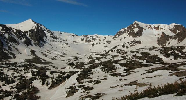
The trail worked its way up to Arapaho Pass through snowfields and rock. I reached the pass and barely managed to stand up in the wind to look down into the lakes on the west side of the Continental Divide before continuing on to Lake Dorothy.

I crossed the snow into the cirque below Mount Neva, donned my crampons, prepared my ice ax, and surveyed the route one last time. I set my sights on Juliet, a narrow line of unbroken snow flanked by rocks. I could see several sets of bootprints up the route, and saw where they veered to the left to bypass the overhanging cornice.

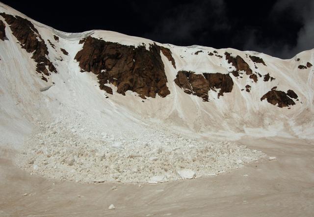
As I crossed the edge of the cirque, I saw the remnants of a modest avalanche down Desmonda, the next snow line to the right of Juliet. I made several special notes to myself to avoid getting caught in an avalanche. To the north of the cirque, on a low ridge separating the cirque from Lake Dorothy, I saw that the prevailing winds from the north had blown a giant cornice.
I made my way to the base of Juliet and began climbing. The snow was soft; late snows and warm temperatures kept the snow looser and softer than I expected. Soft snow seems better for traction -- I had no trouble kicking steps that held my entire foot, up to my ankle -- but the softer the snow the more likely it will slide. I continued upwards, as the snow grew gradually steeper. As I passed the narrowest point of the "hourglass-shaped" snowfield, the snow seemed to be a modest forty-five to fifty degrees; above the hourglass' neck, the snow grew steeper and seemed to pass sixty degrees as I climbed toward the headwall and veered left to avoid the cornice obscuring the direct exit. (I know I'm not supposed to be a good judge of slope while in the midst of a climb, so my estimates should be taken cautiously, but it did feel steep.) The headwall itself was a knee-high snow step; I took the step carefully and quickly realized what I would do with a second ice tool: I'd be able to keep three points in contact with the snow at all times, rather than two. The snow soaked through my thin fleece gloves as I made the final class-three move onto the flat expanse of snow on top of Juliet.
I cautiously walked to the edge of the snow, buffeted by the strongest winds I've felt, which threatened to knock me off my feet. I removed my crampons and scrambled the last hundred meters to the summit. The wind grew even stronger as I reached the summit; I dropped my pack and crawled onto the highest rock to avoid getting blown off the mountain. A casual survey for a summit register failed to locate anything, so I returned to my pack, ate a snack, surveyed my surroundings, and contemplated my descent plan.
I descended via the soft snow on Mount Neva's north slope, trying to maintain a good line between the rocks littering the slope and the steeper, corniced slopes to the west (my left, as I descended). I couldn't see the slope below me, but I knew from looking up at the slope that there were some rocks but no overhanging hazards. As I descended, I could only see the rounded edge of the snow immediately ahead of me and the cirque floor, hundreds of vertical feet below; I couldn't see all of my descent route to properly identify the route to take. I descended cautiously, until at length I navigated the rocks and could see the straight descent route to the bottom of the cirque. The snow was still a robust slope, giving me the opportunity to plunge-step as I descended.
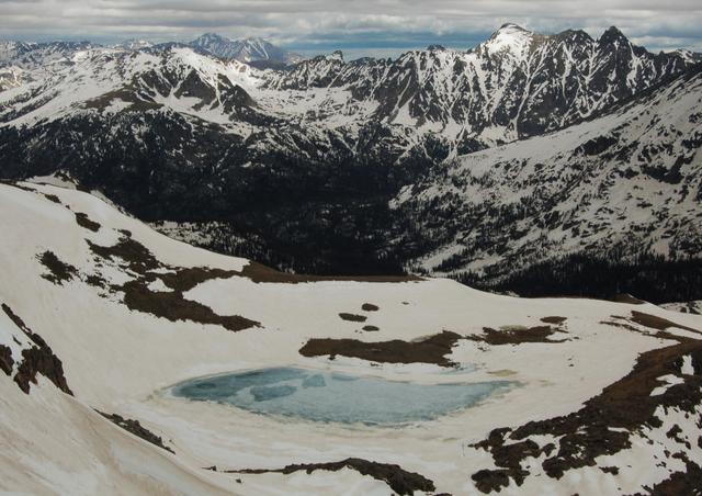
I ate lunch on a rock overlooking Lake Dorothy with a fantastic view of Mount Neva and I knew I had accomplished something. I saw only one person on my descent until I was a mile from the trailhead, when the trail filled with those on afternoon expeditions. Wearing gaiters and carrying unused snowshoes and a well-used ice ax, I felt modestly out of place, though I told myself they were the ones out of place and I was right where I wanted to be.
