Mount Adams
Started: 2008-09-23 07:48:40
Submitted: 2008-09-23 20:25:56
Visibility: World-readable
Willy and I hit the South Climb trail shortly after 0800 on Saturday, 13 September. The trail started as a class 1 stroll along an old logging road, heading north towards the summit. We stopped to pump water in Morrison Creek in a wide wash filled with volcanic rock and sand. We could see Mount St. Helens to the west and Mount Hood to the south.
After the creek, the trail started climbing towards the base of Crescent Glacier. The trail grew rockier and steeper as we climbed to the left of the glacier. The trail gave out as we picked our way through the rough volcanic rock. We studied the maps and guidebook and decided to cross the glacier, giving us our first plausible reason to break out the ice axes Willy rented from Whitman College's Outdoor Program. We avoided slipping on the gentle upper portion of the glacier, which here resembled a Colorado-style permanent snowfield more than a true earth-moving glacier.
We ate a snack in a low stacked-stone shelter on the Lunch Counter and studied the steep southern face of Suksdorf Ridge. Willy's guidebook suggested that we should climb the western portion of the ridge unless we wanted to climb the snowfield, so we took the boulder route and began serious class 3 scrambling. The slope was steep enough and the rocks were loose enough that I was never quite sure whether a backpack-sized rock would start rolling down the mountain when I stepped on it. Willy and i took to climbing next to each other, rather than one in front of the other, to avoid rolling rocks onto each other.
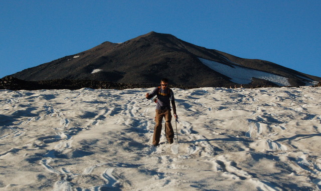
We eventually reached a snowfield halfway up the ridge and decided to try climbing the snowfield rather than the adjacent rocks. We pulled out our ice axes and respective traction devices. I brought my Yakitrax shoe-chains, which were a bit under-powered for a true glacier but worked well enough on the snowfield. Willy rented crampons, which he couldn't get to stay on his feet. He gave up on the snowfield and scrambled up the adjacent rocks, within visual range of me on the snowfield. I climbed slowly and steadily, keeping two of my three points (two feet and ice axe) on the snowfield at any one time.
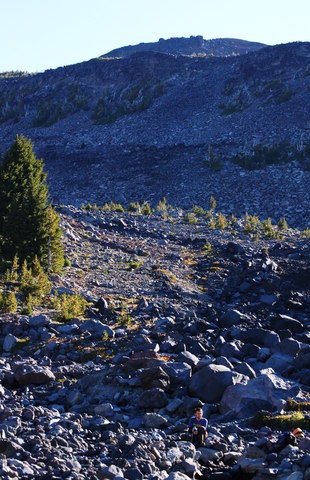
Above the snowfield, the terrain turned sloppy. The fist-sized volcanic rock was smaller than the boulder route below and covered in dirt and sand. For every two steps I took up the mountain, I slid back one step. The occasional backpack-sized rock in the scree was balanced precariously on unstable rock below. Rocks that big aren't supposed to shift when I step on them.
We crested Pikers Peak and I started to worry about the time. We didn't have to worry quite as much about afternoon thunderstorms as we would in Colorado, but I did want to get off the mountain before dark. I asked my GPS receiver to display the current time and local sunset time on its display and noticed that we were half an hour from the half-way point of daylight on our expedition. We decided to turn around at 1500 -- in an hour and a half -- if we hadn't yet reached the summit.
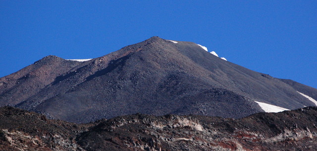
For most of the climb to that point, we couldn't see the real summit of Mount Adams; Pikers Peak stood out as the false summit. (I wondered whether anyone who tried to worship the mountain from the south -- with only the false summit visible -- would be worshiping a false god.) Having crested Pikers Peak, the true summit of Mount Adams loomed high above us across a low saddle. The terrain was more gentle and more stable than it had been on the final ascent to Pikers Peak, and there was more of a trail.
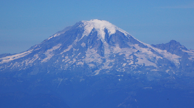
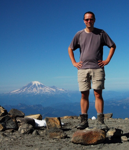
We reached the summit shortly before 1500 and quickly made our way over to the summit cairn a hundred meters north-east of the summit house. When we arrived, we could see Mount Rainier -- the only summit in the state of Washington (or anywhere within hundreds of miles) higher than we were -- laid out to the north. The day was clear but a bit hazy, perfect for climbing.
We found Tibetan prayer flags embedded in the summit cairn and Willy meditated on the summit. We took various pictures of each other and headed back to the summit house to sign the register.
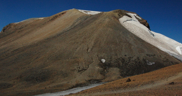
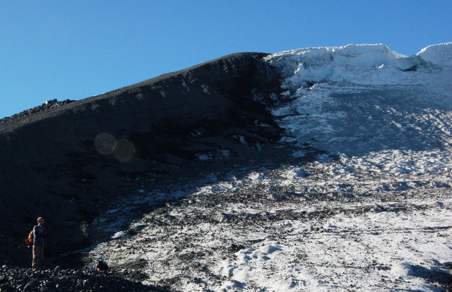
At length we began our descent. The route back to Pikers Peak was easy. I stopped to pump water near the false summit and had some trouble getting my pump to work, but I eventually convinced it to behave and we headed down the eastern portion of Suksdorf Ridge, next to Klickitat Glacier. Unlike the permanent snowfields I'm used to in Colorado, I declared this glacier to be a big-G Glacier, complete with huge chunks of ice cleaving apart from one another and reshaping the terrain underneath.
The descent on the eastern side of Suksdorf Ridge was easier than the ascent. It was hard to tell whether the rock was more stable (taking two steps down and sliding the third was a net gain), but we did find what looked like a common path that served us well most of the way down.
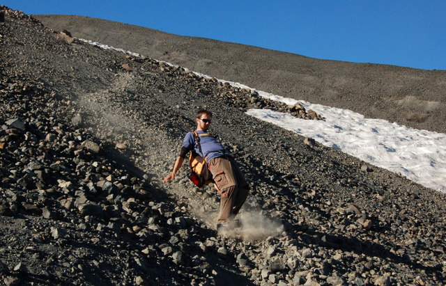
At the bottom of the ridge, we veered south-west, skipping the Lunch Counter, and glissaded down the gentle upper section of Crescent Glacier before joining the designated trail for the descent into camp.
We tried to stop for water at Morrison Creek at dusk, but there was no water to be found; the setting sun was no longer melting the snowfields to feed the creek. I studied the map to find alternate sources of running water and decided that there were some we might be able to find from camp. We continued down the trail as darkness fell; both of us had head lamps but the trail seemed rockier than it had that morning. At one point, the rising full moon shone directly down the trail, illuminating our path brighter than our head lamps. We finally reached camp in full darkness after 2000, having spent twelve hours climbing the mountain. We had enough water left in our bottles to cook supper, and just enough energy to eat and go to bed.
I found water the next morning at the eponymous Cold Springs half a mile from camp, which gave us enough water for breakfast and to make the trek back to civilization. Willy dropped me off at Pasco's airport and I eventually caught a CRJ-200 for my flight back to Denver and my regular life. I was excited that we managed to achieve our objective and began to plan future expeditions climbing Cascade stratovolcanoes in the Pacific Northwest and climbing the highest points in all eleven contiguous United States.
