South Point
Started: 2018-04-04 19:52:46
Submitted: 2018-04-04 23:33:32
Visibility: World-readable
In which the intrepid narrator sees a coffee farm and a black sand beach, and visits the southernmost point of the United States
Our first order of business on our second day playing tourist on the Big Island was to visit the Tree Molds in Hawaii Volcanoes National Park. There were a couple of holes where lava had flowed around trees in a forest and the tree trunk had stood long enough to leave a casting of the tree trunk in the rock, before the tree died and rotted away. The molds were set into the ground, and most had fences around them to keep humans from falling into them. In some cases trees had begun to grow down into the molds, draping their roots along the side of the casting left by much older trees, like children perched on a tomb. (I saw the same sort of thing in Oregon last summer, where a short loop hike took in dozens of molds in the lava flow.) It was worth a quick glimpse, but was not especially impressive.
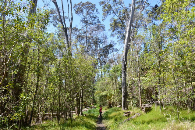
Our next stop was the Kipuka puaulu forest loop trail a short distance down the road. This trail included numbers marked along the trail corresponding to sections in the guide, which I pulled up on my phone, but I didn't feel inclined to try to narrate it as the rest of my family marched on ahead.
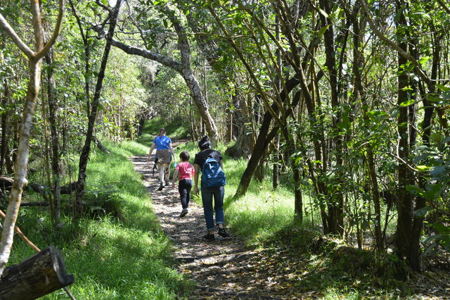
The air was filled with bird song, but I saw only a few birds in the trees (and a handful of pheasants under a tree). Light filtered through the trees of the forest, restored from grassy pasture into something resembling the original forests on this side of the island.
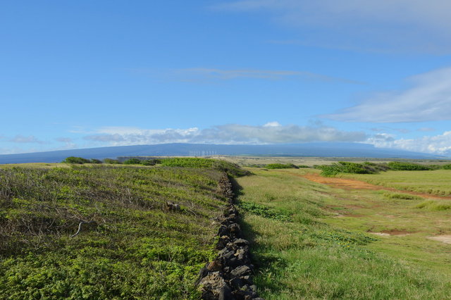
After the hike, we returned to the Hawaii Belt Road and continued south-west, through the Ka'u desert, a broad expanse of lava where the encroaching jungle is kept at bay by acid rain downwind of the main vents of the active volcano Kilauea. As we descended the scenery shifted abruptly to jungle, and as we approached the town of Pahala, I could see plantations lining the road on both sides, dense macadamia nut trees
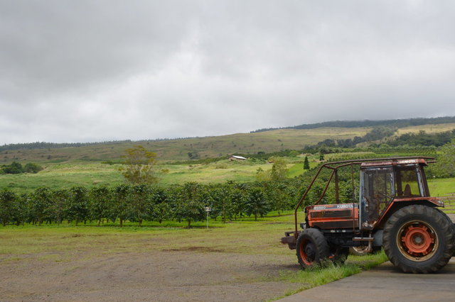
We turned off the highway and drove through the town of Pahala, originally a sugar plantation town now surviving on tourism, coffee, and macadamia nuts. (I saw a number of the historic buildings in the town on Airbnb.) We drove north of town to the Ka'u Coffee Mill, perched on the hillside surrounded by squat coffee trees with large glossy leaves.
I stepped inside the small visitor's center, tasted the various roasts of different coffees, and walked around the back of the visitor's center to try to see what I could see of the coffee farm and the processing operation. (The video that was supposed to be playing explaining everything had failed in the recent rain.)
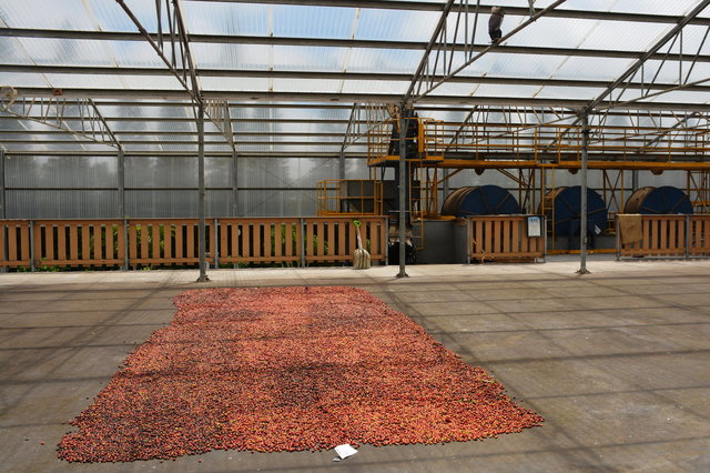
I saw 'natural process' coffee drying under a big open-air awning, with the mechanized dryers in back for regular, more uniform, less-earthy coffee. I saw the shed where the coffee fruit from the trees would be unloaded, cleaned, and hoisted onto conveyer belts; and the idle coffee roasters waiting for beans. Very little was happening on the farm; the coffee harvest isn't until fall, so all I could see was the farm at rest, growing quietly, waiting for the harvest.

I bought a bag of Ka'u coffee (to supplement the one I bought in Safeway on Sunday, which I'd already been drinking) and another bag of coffee from Hilo.
We continued clockwise around the Hawaii Belt Road to Naalehu, the southernmost town in the United States, and stopped at a convenience store, called Wiki Wiki Mart (I'm told "wiki wiki" means "very quick" in Hawaiian; and gave its name (via the shuttle bus at Honolulu International Airport) to the modern internet wiki), to pick up wipes and other essential supplies. I took the opportunity to pick up a pair of flip-flop sandals, which my guidebook assured me was a very Hawaiian thing to do.
The town of Naalehu reminded me more of the languid tropical small towns I saw in India: narrow streets branching off a single main highway, lined by giant banyan trees, with a run-down convenience store popular with the locals. This was part of the tropical experience that I expected to see when I came to Hawaii, and it felt immediately familiar.

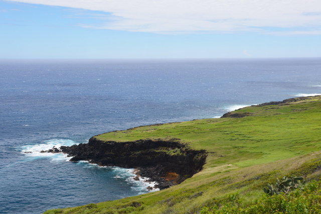
The scenery around Naalehu was stunning: brilliant green grassy fields sloped gently to steep black cliffs above waves breaking white bordering brilliant blue ocean, below a pale blue sky spotted with clouds floating languidly through the sky. To the north the highway wound its way back towards Hilo, cutting through the forest sloping gently down to the ocean.
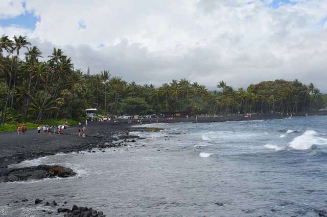
Properly fortified, with appropriate beachgoing footware, our next stop was a few miles back up the road at Punalu'u Black Sand Beach. We ate lunch at a picnic shelter next to the parking lot, then made our way to the idyllic beach, tucked between towering palm trees surrounding a small cove filled with pounding surf. (All of the beaches on the south and east side of the Big Island are formed by lava hitting the ocean and forming black sand.)

The water was rough enough that swimming wasn't recommended, but there was a small section of shore where a breakwater had been constructed out of rocks that provided a small cove where our kids could wade. (I tried digging in the sand, but it was too coarse to get much definition, and the sand next to the water was quickly inundated by waves.)

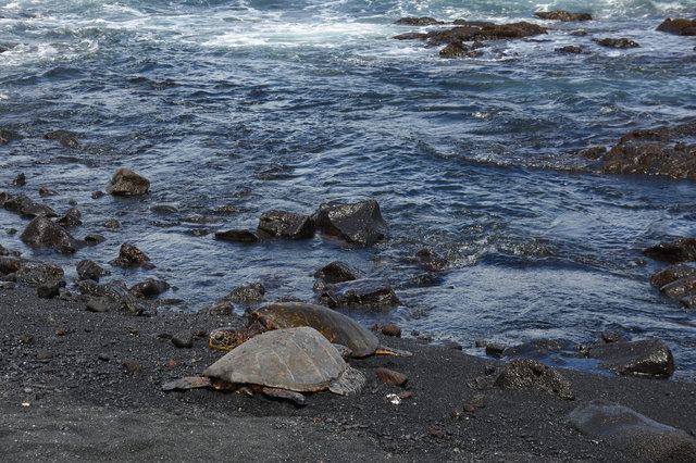
Sasa spotted sea turtles playing in the surf, barely out of view, visible only when the wave broke just right. I climbed onto the rocks overlooking the beach and tried to photograph them, but ended up with a bunch of pictures of blurry green blobs lurking under the water. Further up the beach was a section of sand enclosed by a low rock wall where several sea turtles were languidly sunning themselves on the tide line while curious beachgoers leaned over the wall to get a better look.

After a few hours (during which I managed to sunburn my feet where the strap on my sandals didn't cover) we left the beach and drove back through Naalehu to South Point, the southernmost tip of the Big Island and the southernmost point in the United States. The road cut through a swath of bright green grassland as it descended, with ocean visible on both sides and ahead of me, and the low bulk of the volcano looming behind me. It felt like I was driving towards the end of the map, to the very ends of the earth, reminding me of my hike to Tomales Point last summer. The paved road narrowed into a one-lane road with an unpaved shoulder to allow oncoming traffic to pass, and eventually terminated in a dirt parking.
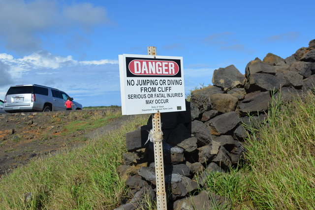
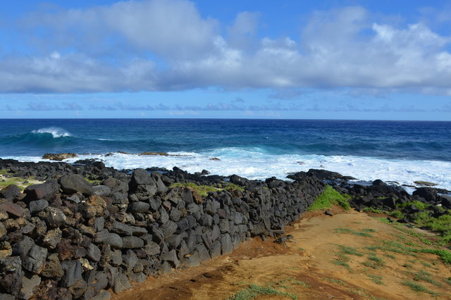
Next to the parking lot was a sign warning against jumping off the cliff, which was clearly unheeded, as groups of people whose self-preservation instincts are tuned very differently from my own were clustered around the cliff, where a flimsy diving platform was perched on the edge, contemplating the jump off the cliff into the ocean below.
I walked past the lemmings in search of the southernmost tip of the island. I found the point where land ended and ocean began, where black volcanic rocks in the intertidal zone gave way to waves and the cobalt blue ocean stretched all the way to the horizon. I stood on the southernmost point of the United States, listening to the waves crash on the rocks, feeling the wind in my hair and the sun on my face, enjoying the moment and the place and feeling amazed that I was there to experience it.
We returned to the car and retraced our route north, following the narrow road as it turned into a proper two-lane road, then joined the Hawaii Belt Road for one last look at Naalehu, and onward to Volcano. It started raining as we drove through the Ka'u desert, and subsided only slightly when we stopped for supper at a cafe in Volcano. We claimed the last non-rainy seats on the patio (protected from the weather by an ample awning clearly designed for this purpose) to eat supper.
After eating, once it was dark, we drove back into Hawaii Volcanoes National Park to the Jaggar Museum at the end of Crater Rim Drive, where crowds of tourists were gawking at the glow put off by the lake of lava inside Halema'uma'u Crater. The plume of smoke above the lava was glowing a bright impressive red.

After seeing the crater, we drove back to our Airbnb to sleep before another day on the island.

For more photos from my day in Hawaii, see Photos on 2018-03-27.
