Gattaca
Started: 2018-08-12 20:36:40
Submitted: 2018-08-13 00:03:25
Visibility: World-readable
6 July 2018: In which the intrepid narrator visits the building where Gattaca was filmed, and finds a vantage point from which to look down on San Francisco
After spending my last week on-call for App Engine, living alone in an empty house while Kiesa started her job in Seattle, I took Friday off (after the mid-week Fourth of July holiday) to spend a long weekend at Point Reyes. I had wanted to kayak in Drakes Estero, now that the Park Service had opened the inlet to kayaking after the harbor seal pupping season, but the weather forecast looked windy so I decided to hike instead. Along the way I took a guided tour of the Marin County Civic Center, designed by Frank Lloyd Wright and used as the setting for Gattaca and other sci-fi movies, inspired by Willy's visit to the building in June.
Although Google Maps wanted to route me to San Rafel through the East Bay (via a two-for-one bridge deal transiting both the Bay Bridge and the Richmond-San Rafel Bridge), I chose the alternate route straight across the Golden Gate Bridge, continuing up 101 through Marin County.

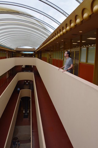
I arrived at the civic center, a sprawling building on a large campus, armed only with a vague idea where I was supposed to be going. I entered the building, through one of the arching entrances, and found the cafeteria on the second floor, empty but for a loose group of people waiting for the guided tour.
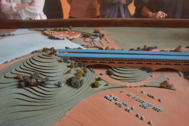
Our tour guide was an older gentleman, of retirement age, who talked about the history of the building, and Frank Lloyd Wright's ideas of using the hills already on the site rather than bulldozing them. The building was laid out in two pieces, with a long four-story section on one end connecting to a large dome in the middle (over the library on the top floor, directly above the county commissioner's council chambers), then turning at a shallow angle to a two-story section spanning the gap to the next hill. (The dome was under renovation and covered in scaffolding, thwarting my attempts to get a good picture of it, and it appears that I neglected to get a decent overall picture of the architectural models either.)

Our guide led us up and down the corridors of the building, starting with the atrium with the escalator leading into the building -- the same escalator that Ethan Hawke rode in Gattaca (and gave a genetic sample at the top to prove that he was "valid"; as we rode the escalator I could hear the gentle chime of the screening equipment in the movie as if each of us were being validated for entry).

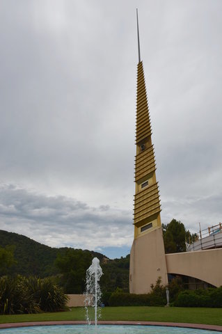
The whole building was amazing -- from the weird golden trim (meant to reference the "golden" hillsides, which we could see above the building when the tour took us outside) to the spire (which, our guide told us, Wright convinced the county to allow by claiming it could be used as an antenna for public safety).
I was especially impressed by the geometric patterns of cutouts on the exterior walls, and fascinated by the patterns on the roof designed to divert rainwater, all built out of gracefully-curving reinforced concrete.
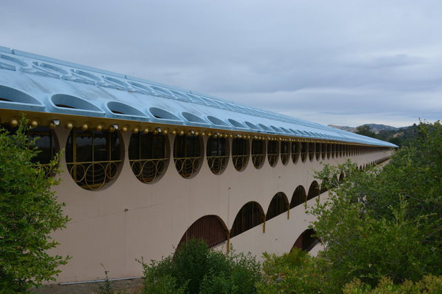
According to our guide, Wright wanted to paint the roof golden, but couldn't get enough gold paint to make it work, so he settled on a pale blue to reference the color of the sky.
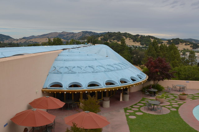
We stepped out onto the balcony behind the council chambers for a close-up view of the roof and the glass covering atrium, stretching out in a long line for hundreds of meters.

At the end of the tour, I asked our tour guide to take a picture of me on the railing, since there was no way I could get a good shot of me on the railing without help. I tried to remember the scenes in which Ethan Hawke looked through the glass roof of the atrium at the rockets launching, and settled for just looking up, over the atrium, four floors above the ground.
On my way out of the building after the tour I stopped by the library, located under the dome at the center of the building. Kiesa is now working in a library designed by Rem Koolhaas, which is pretty cool, but so is a library designed by Frank Lloyd Wright.

Marin County could have built a boring square office building, but instead it built an architectural marvel, and the world is a better place because of it.
I left the civic center, ate lunch at a taqueria in a nearby strip mall, stopped by Target for fortifications for my trip (and for living alone in an empty house), then headed to Mount Tam.
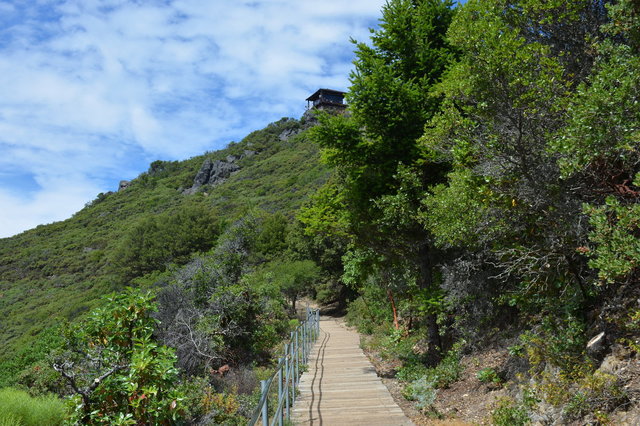
Mount Tam (otherwise known as Mount Tamalpais, which no one can pronounce or spell, so we just say "Mount Tam") looms over the southern part of Marin County, and is visible from much of the Bay Area, but isn't especially distinct. Like most of the high points in the Bay Area, there's a road leading almost directly to the top, which took away most of my interest in visiting the summit (because, to my Colorado-steeped mind, driving to the top would be cheating). But I put Mount Tam on my todo list, and as I drove up the twisting road leading to the state park at the top, though redwood trees and eucalyptus groves, catching glimpses of the bay and the cities surrounding it and the ocean to the west, I knew it was a place I wanted to visit.
I parked near the top of the mountain, and began my exploration by circumnavigating the summit on a short trail. The bright summer sun bore down on the trail, unencumbered by any fog, and the few thousand feet I'd gained since leaving San Rafel did little to cool the air. The trail gave me glimpses of view, breaking it down into manageable chunks: first I could see the Marin Headlands descending into the Pacific Ocean, then I could see the city of San Francisco laid out before me, then I could see the bay and the cities of the East Bay and North Bay.
From my vantage point, perched along the side of Mount Tam, I could look down on San Francisco, which is not a perspective I'm used to. It occurred to me, though, that large chunks of the country's conservative pundits make a habit of (figuratively) looking down on San Francisco (and the values we stand for).
I completed my circuit of the mountain, then climbed the trail leading up Mount Tam to the summit. A fire lookout sat on the very top of the mountain, thwarting my desire to stand on the tallest rock and directly observe the surroundings, but I did manage to observe a good chunk of the Bay Area in one view. I could even see the Faralon Islands, 25 miles off the coast, no longer clinging to the horizon now that I was 2500 feet above sea level. (This may have been one of my best direct observations of the curvature of the earth.) It was the only place where I had been able to look down on the Faralon Islands while standing on solid ground.

I left Mount Tam and descended towards the ocean, down hillsides covered in golden grass and towering oak trees that reached all the way to the ocean glistening in the afternoon sunlight. I stopped in Point Reyes Station to get gas, then drove along Sir Francis Drake Boulevard around the western side of Tomales Bay. I found my Airbnb, tucked away in the forest, then returned to Inverness to eat supper at Fog's Kitchen overlooking the bay. Several of the items on the menu featured blue cheese from Point Reyes, and I obliged the menu by ordering the blue cheese garlic bread, which was in fact quite good, with delightfully-tangy blue cheese on crisp buttery bread.
I returned to my Airbnb for the night ahead of the hike I had planned for the next day.
For more pictures I took at the Marin County Civic Center, see Photos on 2018-07-06.
