Kayak Academy
Started: 2019-10-06 14:54:55
Submitted: 2019-10-08 00:50:01
Visibility: World-readable
In which the intrepid narrator takes an overnight class and plays in the tidal currents at Deception Pass
After buying a kayak this summer, I was ready to upgrade my kayak knowledge with a two-day "Open Water Training Camp" offered by Issaquah-based Kayak Academy. This class follows up on the two-day kayak class I took from Kayak Academy last year with an overnight kayak camping trip somewhere in the San Juan Islands.
The class gave a long packing list of gear I didn't already have: a larger selection of dry bags, a spare paddle, a waterproof flashlight, and rocket flares. (As a small human-powered boat, I am exempt from the Coast Guard's requirements to carry visual distress signals, but it's still a good idea to have rocket flares to signal in the event that I happen to need them.) At first I couldn't figure out where I was supposed to get rocket flares -- none of my normal sources carried them -- until I discovered this was precisely the sort of thing that West Marine carries. I had never actually visited West Marine, mostly so I did not become possessed with the urge to buy any of the expensive boating equipment it sells. (Through conversations with my nautically-minded coworkers I decided to refer to the store as "Boat Depot".) I visited West Marine in Ballard and picked up the rocket flares I needed. I counted my visit to the store as an important cultural experience.
Kayak camping, it turned out, was a weird hybrid of backpacking and car camping, with the added feature of being on the water. I could carry substantially more weight than I could in a backpack -- my kayak itself weighed fifty pounds, approximately the weight of my full backpacking backpack; fully loaded the kayak could carry a great deal of camping gear, as long as I packed it carefully. But the "careful packing" proved to be tricky: I bought a bunch of dry bags to keep my clothes and sleeping bag dry, and then I had to repack everything to make sure I could fit it all in the modestly-sized hatches forward and aft on my kayak. Then I unpacked the kayak and put everything in the back of my car so I could lift my kayak onto the roof of my car to drive to the
As the second weekend in September approached, the risks of scheduling the class on the shoulder season grew apparent: Faced with the prospect of high winds, the class relocated from Anacortes (where we would have had to paddle across the open water of Rosario Strait) to Cornet Bay, adjacent to Deception Pass, relatively better protected from the force of the wind by the bulk of Whidbey Island.
I drove to Whidbey Island on Saturday morning, 14th September under cloudy skies. The mist grew especially heavy as I crossed the bridge over Deception Pass and turned off the highway to park at the marina at Cornet Bay. The clouds hung low in the sky, threatening rain at any moment, but the rain held off until evening. I spotted other people milling about with kayaks on their cars who turned out to be there for the class. Most of the people there had already taken three days of classes together, including the two-day intensive class I took last year. In total we had eight people: six students, one teacher, and one alumni along for the trip.
Our instructor George had a series of handouts for me, plus a local nautical chart in a waterproof case. We assembled on a picnic table overlooking the muddy beach to review the plan (paddle east to Skagit Island) and go over the tide and current tables to confirm where the tidal currents were going to be going as we paddled. (Deception Pass in particular is notorious for extreme tidal currents, up to eight knots, far faster than a kayaker can paddle.)
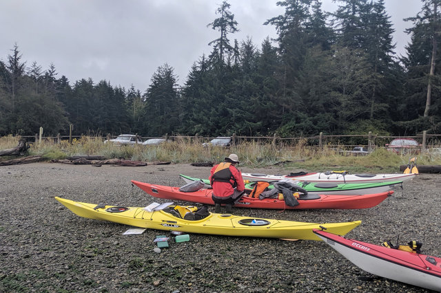
We carried our kayaks to the beach and loaded them for the trip. I repacked some of my gear in the loaner dry bags; in particular, one of the bags was designed with a taper to hold a tent in the tapered bow of the kayak. I put on a dry suit (also provided by the class) and we launched our boats into the quiet water of Cornet Bay.
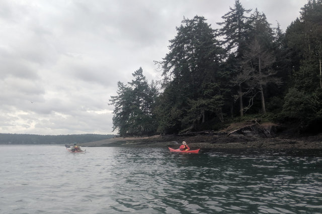
We paddled towards Ben Ure Island in the middle of the bay, practicing keeping two range marks at different distances lined up so we could tell whether we were on course or not, and make course corrections as necessary. This became more relevant as we turned into the main channel leading towards Deception Pass, where the ebb current was flowing out through Deception Pass at a sedate one or two knots. We ferried across the channel to the shallow water east of Strawberry Island, using the gentle current to get a feel for how the current would affect the boat and our navigation -- and how the current changed at different points in the channel, based on the complicated fluid dynamics of the channel and the water around me.
We stopped next to Strawberry Island where thick kelp floated on the surface of the water and harbor seals stuck their heads above the water to investigate us. It was hard to get a good count of the seals, since they submerged and emerged intermittently, but based on their positions it seemed like there were four or five seals around us as we drifted on the kelp. The seals only stuck their heads above the water; from their chins upwards they looked like streamlined wet dogs optimized for the water -- which, I suppose, they are.
From Strawberry Island we turned east and paddled to Yokeko Point, against the gentle tidal current, taking turns leading the group towards the point, trying to remain on course regardless of where the current was trying to push us.

East of Yokeko Point the water opened up; we were no longer protected from the wind by the bulk of Whidbey Island. The ten-knot south-easterly wind blew across Skagit Bay, kicking up two-foot waves. Half-way across the bay we stopped to try surfing the waves: waiting for a big wave, then paddling to try to let it catch up with me while I was going fast enough to catch it, then trying to let it carry me along with it. I wasn't very good at it but it was amusing.
We continued paddling across the bay, perpendicular to the breeze. We reached Skagit Island and landed on the small beach on the north-east side of the island, across a narrow channel from Kiket Island, itself connected to Fidalgo Island by a bridge on the far side.

When we landed on Skagit Island the tide was near its lowest ebb. We checked the high-tide mark on the beach, and checked in the tide tables how tonight's high tide compared to this morning's tide, and carried our boats up above the high tide line. We went ashore at Skagit Island Marine State Park, featuring a small campground complete with a pit toilet, a couple of picnic tables, and a handful of campsites. We fanned out onto the island and pitched our tents. (I discovered that I had left my tent stakes in my car, the result of my apparently-haphazard repacking into the dry bags provided by the class; I borrowed enough tent stakes from another member of the group to properly secure my tent for the night.)

Our instructor told us how to find edible seaweed in the intertidal zone and discussed weather forecasting and how to use a marine radio. He told us about nautical charts and a bunch of other stuff I should remember (and I can double-check next time I think I might need it because it's all in the handout I kept). The wind kept us on shore for the afternoon, but protected in the trees on the island the camp site was calm. We cooked a shared potluck supper -- I brought vegan chili (cooked on a camping trip to the San Juan Islands in the summer, then frozen until needed), and other people brought pasta and salad and dessert and other food to share. We had more than enough food; I didn't need the emergency backup freeze-dried backpacking meal I brought just in case.
After supper (and hot chocolate, and struggling with the built-in starters on the JetBoil stoves other people brought before giving up and using the disposable lighter I brought) the sun set and the wind picked up and the ominous low clouds finally began, tentatively, to rain. I retreated to my tent for the night as the rain picked up, and kept raining all night; but I stayed warm and dry in the tent.

The rain let up by the time I woke up Sunday morning. I ate breakfast (packaged oatmeal and coffee; in a concession to packing volume I ground my coffee before packing), then packed up my tent. There was no way I could reasonably expect to dry out my tent before packing it, so I packed it with the rain fly and ground sheet still soaking wet from the night's rain, and resolved to set up the tent in the garage to let it dry out.
I packed my kayak (trying to remember where I had put everything) while a harbor seal checked us out from the water, then we launched and began paddling clockwise around Skagit Island, under the cliffs surrounding the island and through the giant strands of kelp floating on the surface in the gentle tidal current.

We paddled west, out from Kiket Bay towards Hoypus Point on the northern edge of Whidbey Island. The tide was ebbing, draining out of Skagit Bay to the south towards Deception Pass ahead of us, out of view beyond the point.
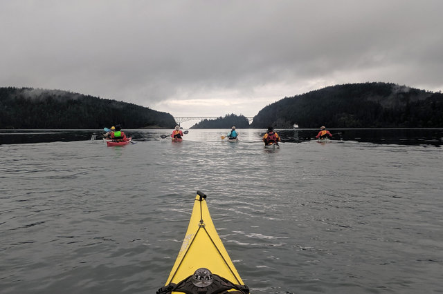
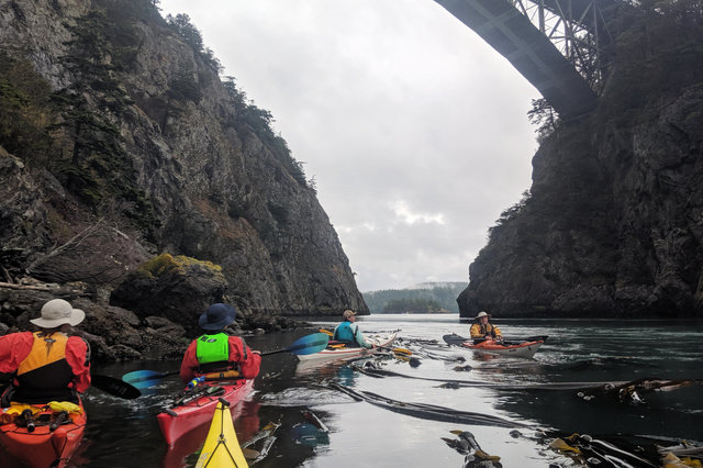
We rounded Hoypus Point and headed towards Deception Pass, watching out for other boat traffic, though only a few motor boats were out early on a gray Sunday morning, and some of them were sitting at anchor. We kept north of Strawberry Island and Canoe Island, and as we approached Canoe Pass, the tidal current picked up, pulling us at a robust five or six knots through the narrow pass, between steep rocky cliffs on both sides, the graceful arch of the highway bridge high above us.

The current grew weaker on the far side of the pass, and we paddled out of the main flow into the eddy current in the lee of the rocky point. Here I could clearly see the distinction between the fast-moving water in the channel, the whirlpools forming at the edge of the eddy, the backwards-moving eddy, and the gentle water in the shallows next to the rocks. It was all a fascinating study in applied fluid dynamics.
Our instructor sent us out into the fast current to give us practice entering and exiting the stream and handling the transitions between the different water, looping back into the eddy in a big circle, then trying it all over again. At first I was nervous, but after a couple of repetitions I gained confidence, and we changed the game to cross the current onto the eddy on the other side of the channel, then ferry back and forth across the channel -- and finally to paddle straight into the current, letting it carry me backwards as I ferried across the channel to the eddy on the opposite shore.

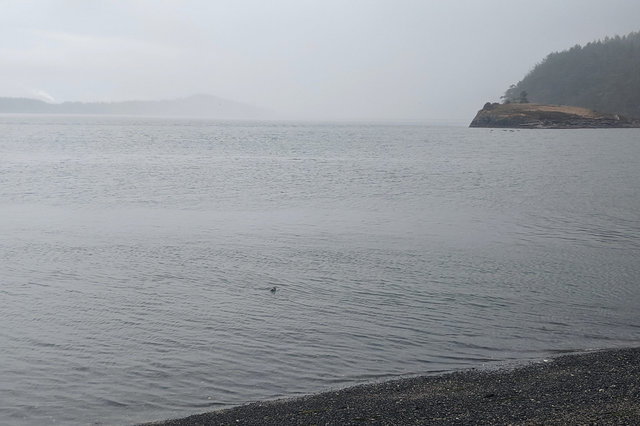
We left the current and eddies at Deception Pass and paddled to the west, out towards the open Strait of Juan de Fuca, open to the unfathomable vastness of the Pacific Ocean, where the gray clouds merged with the gray sky and met the steel gray water at the horizon.

We stopped short of the strait and went ashore at a beach on the south side of Reservation Head, near Lighthouse Point. (I had in fact visited this very beach earlier this year on a visit to Rosario Marine Station, a couple miles up the coast on Fidalgo Island.) Our instructor set up a rain shield and we ate an early lunch and went over more class materials, covering the light schemes used by various boats, and a bunch of other material in the handout I should review at my convenience.
We waited for low tide to turn the ebb into flood, flowing back into Deception Pass to carry us back to our cars parked at Cornet Bay. We launched back onto the water and paddled through Deception Pass, past people fishing from boats and the shore, into the calm waters of Cornet Bay.

We landed, unpacked our kayaks, loaded them onto our cars, debriefed after the trip, and headed back to civilization, after an amazing educational kayak trip through Deception Pass.
I have a few more pictures from kayaking through Deception Pass at Photos on 2019-09-15.
