Dumbarton Rail Bridge
Started: 2021-01-04 14:36:25
Submitted: 2021-01-04 17:14:45
Visibility: World-readable
In which the intrepid narrator paddles from Palo Alto Baylands to the abandoned Dumbarton Rail Bridge, rusting away in the middle of the bay
For most of my adult life I've taken the week between Christmas and New Year's off work, either because I was visiting family or planned a vacation or visiting friends or I just wanted to take time off. This year my new employer gave me the whole week off as holidays, so I didn't even have to take vacation time. I took the opportunity to kayak from Palo Alto Baylands into San Francisco Bay on Tuesday, the 29th of December.
On my way down the mountain I dropped by REI to pick up a waterproof map of San Francisco Bay, a reproduction of the NOAA chart, with the area around Palo Alto Baylands zoomed in. I carried the folded chart on the platform formed at my lap by my spray skirt, giving me easy access to the chart whenever I needed to check my position, keeping track of where I was given the nautical landmarks around me.
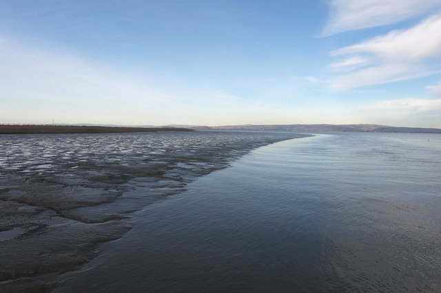
While looking at charts of the southern part of the bay, and comparing the navigation charts to maps, I noticed a gap between their respective views of the world: charts are concerned mostly with water that remains navigable at low tide, while maps show land that remains dry even at high tide. Both of these omit the intertidal zone: mud flats and salt marshes that are not especially useful to humans (so they tend to get filled in or diked to make salt ponds) but are important wildlife habitats. My kayak will float in six inches of water, so I can paddle over most mud flats at high tide, but it's awkward to paddle in less than two feet of water; if I'm not careful I'll find mud on the blades of my paddle.

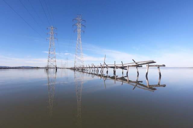
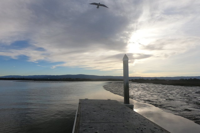
I launched from the hand-carried boat dock at Palo Alto Baylands under almost-perfectly-clear skies. The tide was high and ebbing, and the water in the slough at the boat dock was as smooth as glass. From the boat dock I could see opposite the slough where the trail ran from Mountain View along the top of a dike; there were people walking along the trail as I paddled along. I took advantage of the high tide and paddled behind Hook's Point, between the dike and the salt marsh where a pair of high-tension transmission lines ran along the edge of the bay.
As I paddled the channel grew narrow and eventually threatened to disappear (I double-checked my new chart to prove that I had in fact seen a solid blue line, indicating a permanent channel even at low tide) before I followed it around an S-curve into Charleston Slough.
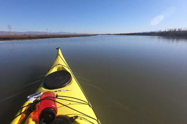
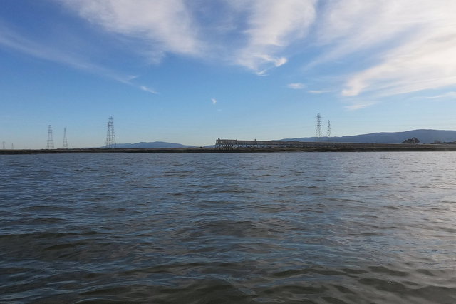
The water opened up and the dike retreated away to my right, to the south towards Mountain View. Across the water I could see the parts of Mountain View close to the shore: airship hangars 2 and 3 at Moffett Field (visible on the horizon on the right in the picture above), the towers supporting the awning over the stage at Shoreline Amphitheatre, and the massive tent-dome over Google's under-construction Bay View Campus.
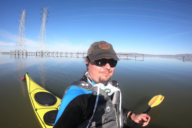
For this kayak trip, I remembered to charge the battery on my GoPro in advance, so I could actually use it while I was paddling. (I also brought a carabiner to hook the camera to my lifejacket when I wasn't using it, visible below my right shoulder the picture above.) Depending what effect I thought would be best for a particular shot, I switched back and forth between the wide view on the camera (giving a fish-eye effect visible in some of the pictures) and the linear view (which still had a huge field of view but stretched the picture so the horizon looked straight). The one thing I forgot was that the camera lens would get splashed with water and needed to be cleaned off (and it turned out that my neoprene wetsuit was not especially well adapted to cleaning the lens); I had several shots ruined by gigantic smudges on the lens.
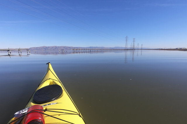
I paddled through the line of transmission lines running along the bay, through a gap where the decrepit maintenance walkway had fallen completely into the bay. I paddled east along the edge of the bay, following the line of the dike at the edge of the salt pond towards the mouth of Mountain View Slough. I thought about continuing to the mouth of Stevens Creek (where I had walked along the dike to the edge of the bay on my last visit to Mountain View in the Before Times in February), but instead I set my sights on the Dumbarton bridges spanning the bay, a couple of miles up the bay from my current point.
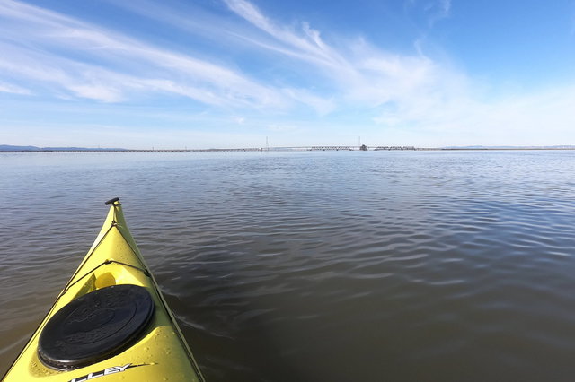
It took me the better part of an hour to paddle down the bay towards the bridges. I was paddling along with the tidal current, pulling me north at about one knot; meanwhile a gentle breeze picked up from the north-east at a couple of knots. To my right, across the bay I could see the Cargill Salt works at Newark; the salt piles looked shortened in a way that suggested that I couldn't quite see the bottom around the curvature of the earth.

Visible in the picture above are four separate crossings of the bay at Dumbarton: the Dumbarton Rail Bridge, with its steel drawbridge span permanently opened after being abandoned in the bay a generation ago; the Hetch Hetchy Aqueduct; the Dumbarton road bridge, carrying California state highway 84 across the bay; and a high-tension transmission line behind the road bridge.

At last I approached the open Dumbarton Rail Bridge, abandoned in the middle of the bay when the rail line was decommissioned. The wind and water lapped against the wooden piles bobbing in the bay under the open span, and I smelled creosote from the treated wood. I studied the structure of the steel bridge, more than a hundred years old, sitting quietly in the harsh salt water, apparently none the worse for wear. I was surprised to note that the center span was wide enough to serve a double track, though the approaches were single-track.
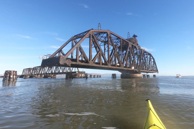
I paddled through the open bridge and turned around to head back up the bay. I saw the cabin at the top of the moving bridge section and the drive shaft running in the open down the side of the truss to the drive gear at the bottom, to spin the entire bridge section around its axis to open and close the bridge. I turned to the west, following the steel trusses towards shore, and I saw the tidal current running around the bridge piers; I had to paddle at a steep angle to avoid getting carried under the steel spans.
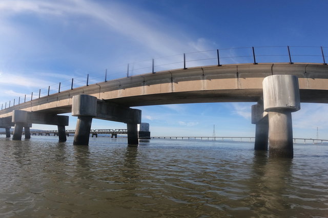
I reached the end of the steel trusses, where the bottom of the bay rose closer to the surface, where a newer prestressed concrete viaduct replaced the original wooden approach truss. Under the viaduct I could see the structure where the Hetch Hetchy Aqueduct rose from under the bay to its own viaduct above the water, carrying water from the Sierras hundreds of miles into San Francisco.

The concrete viaduct ended abruptly where the original wooden truss had stood, carrying the railroad the rest of the way to the shore before being destroyed in a mysterious fire in 1998. In the distance, back-light by the afternoon sun, I could see the ruins of the wooden truss, individual burnt-off piles sticking up from the water.
I turned to the south, heading back towards the Baylands boat dock, squinting against the afternoon sun, heading upstream against the ebbing tide. I watched small aircraft take off and land at the Palo Alto Airport, marking the shore near my destination. I eventually made my way to the water in front of the boardwalk stretching through the salt marsh to the bay at Palo Alto Baylands (which I visited, on foot, a couple of weeks ago); the mud flat was covered by the receding tide but the water was shallow enough that I turned away before I got too close to seek out deeper water to paddle the rest of the way around Sand Point to the boat dock.
By the time I reached the boat dock the tide was obviously much lower than it had been when I launched: the visible mud almost reached the dock, floating in the water, but there was still enough water on the other side of the dock so that I could haul my boat onto the dock and back to my car.
According to my GPS receiver I'd paddled 14 kilometers through the bay, which made for a good afternoon out on the water.