River
Started: 2023-01-21 17:21:25
Submitted: 2023-01-22 22:12:31
Visibility: World-readable
A series of atmospheric rivers bring water and flooding to Santa Cruz
Our Beach Christmas turned out to be the last clear day for a couple of weeks. Boxing Day was overcast, and the rain rolled in late in the day. The morning we left for the airport to fly to Colorado, my home rain gauge read 1.75 inches since midnight. The rain continued in distinct storms for several days (while we were mostly, but not exclusively, sunny and dry in Keystone), culminating in a deluge on Saturday, New Year's Eve, when a massive storm rolled in from the Pacific Ocean to deluge California. San Francisco almost overturned a nineteenth-century one-day rain record, and the Santa Cruz Mountains wrung enough water out of the storm that the San Lorenzo River, running through Santa Cruz into the ocean, flooded. I watched the deluge from afar, trying to keep up with the news from my ski condo in Keystone.
The rain subsided by the time we returned home on Sunday, New Year's Day, letting us drive across highway 17 without incident. On Monday afternoon, before the next rain storm rolled in, I drove down to the Cliff Drive Vista Point to see the state of the river and the adjacent beaches.
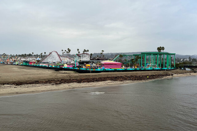
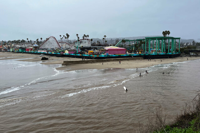
The vista point is on a sandstone bluff above the mouth of the San Lorenzo River. To the west, immediately across the river, the Beach Boardwalk sits on Main Beach. The river had receded, leaving driftwood below the sandy bank at the high-water line.
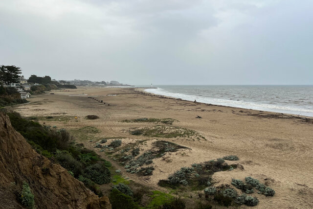
To the east, the overlook looked out on Seabright Beach, which had collected some driftwood after the storm, but still looked like it was in fairly good shape. There were even people playing beach volleyball on the far end of the beach.
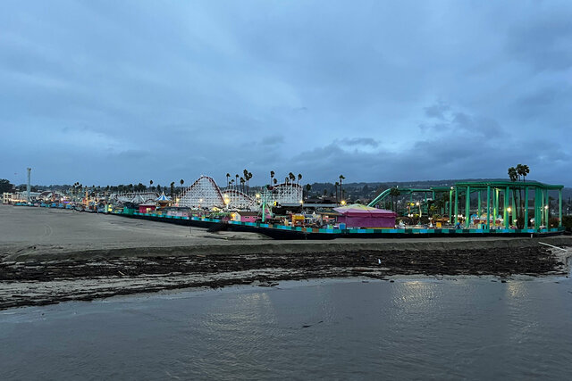
The rain returned Monday night, then picked up again on Wednesday. Late on Wednesday afternoon there was a brief pause in the storm, so I drove down to the overlook again to see what had changed. More driftwood had accumulated along the San Lorenzo River next to the Beach Boardwalk, washed down the river in the storms.
On Seabright Beach, the storm had washed up driftwood in a neat line along the edge of the beach, forming a clear high-water mark running down the length of the beach. The tide was out, leaving a gentle slope of sand leading down to the frothy waves.
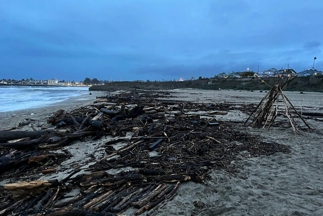
Most of the wood was small enough that I could easily carry it by hand or move it myself, but some of the wood was much larger. There was a massive redwood log that looked like it was 50 feet long that had been washed up on the beach, and I did not want to be around the log when the waves pushed it up on the beach.
The wind picked up as I walked along the beach toward Walton Lighthouse at the jetty marking the entrance to the small craft harbor. I do not have a well-calibrated sense of wind speed, but I roughly felt like the wind had picked up to at least 40 knots. On the beach I could do a credible impression of a weather reporter in an oncoming hurricane.
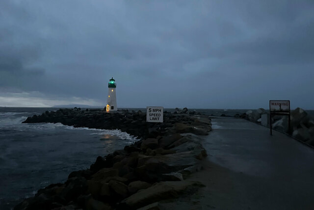
This seemed like a good time to heed the warning of large waves breaking across the jetty at Walton Lighthouse. The wind was blowing directly across Monterey Bay, whipping up waves as it came.
By the time I turned around to head back to my car, walking back along the exposed beach, the rain had picked up again and was being blown almost horizontal by the wind coming off the bay. My rain pants protected me from getting soaked on the walk back across the beach.
The rain continued overnight and into Thursday morning. The San Lorenzo River stayed below flood stage, but the wind and the tide combined with the rain that did fall to flood Capitola and Aptos. In Capitola, the cute beach town was battered by waves (and the logs that the waves carried), and a section from the middle of the pier was destroyed by the waves. In Aptos, houses and buildings around Aptos Creek flooded (I saw a picture of the usually-crowded parking lot at Rio del Mar underwater), and the pier leading to the concrete ship at Seacliff Beach was destroyed, strewing wreckage across the beach. (The pier had been gradually falling into the bay, and the last time I visited the pier sections were blocked off and the last third was completely fenced off.) In Santa Cruz, pieces of West Cliff Drive fell into the ocean, across the street from multi-million-dollar houses.
Aptos and Capitola are both special to me. Capitola was the first beach I visited after moving back to California in 2020, and Aptos (specifically the beach at Rio del Mar) was our favorite beach to visit because we're not quite close enough to walk to the beach (at least, if we want to do anything else at the beach that day), and Rio del Mar has easy parking, a short walk to the beach, a creek providing alternate fresh water to build next to, and just enough protection from the open ocean for Julian to be able to body board. The towns and the beaches will recover and we'll visit them again, but for now I feel a sense of loss that something special to me has been damaged.

After lunch on Thursday, the storm had blown through Santa Cruz (and the river hadn't flooded), so I went back to the overlook above Seacliff Beach to look at the damage. The beach had been pounded by waves all night long up to the base of the crumbling sandstone cliff I stood on, scattering the contents of the beach across the sand. The driftwood that had been neatly lined up at the high-water line on the front edge of the beach had been strewn haphazardly across the entire beach. The 50-foot redwood log had been pushed a hundred meters up the beach in an impressive display of the power of the waves. The fire pits provided by the state beach, which had been lined up in a neat row the night before, were pushed up against the cliff. Angry frothy waves crashed on the shore, but they were just a sample of the true power of the storm.
The San Lorenzo River was running high and fast, but still below its banks. The tide was going out but waves were breaking into the river, and there were people surfing in the river. I could clearly see the point where the muddy water from the river mixed with the relatively cleaner ocean water, in a couple of standing waves at the bar at the mouth of the river.
The river as it runs through Santa Cruz on its way to the ocean has been channeled between a series of levees. There are houses and apartments below the levee on both sides of the river; they're not really below sea level, but they were clearly under the level of the river draining the Santa Cruz Mountains. Pump stations on both sides of the river help drain the lowest areas next to the levees. The pump stations are equipped with backup generators, but in the event the generators fail the lowest areas behind the levee will flood in heavy rains regardless of what happens on the top of the levee. walking along the path at the top of the levee I could see evidence of a bathtub ring of debris on the top of the levee, presumably from waves running up the river and crashing over the top of the levee.

Through the rain I heard both of the sump pumps in my crawl space running. When we bought the house in 2021, the various home inspections pointed out the presence of one sump pump in the crawl space but cautioned that it looked like it was overrun with dirt and they couldn't test it. The foundation inspection pointed out that the ground under the house was damp and suggested adding a sump pump on the opposite side of the house, so we did. The new sump pump is right under the kitchen, and when it turns on it's loud and hard to miss. While sitting in the living room, if it's quiet and I'm paying attention, I could hear a different sump pump turn on, and while walking around on the north side of the house I observed the pump pushing water into the storm drain at the bottom of the gutter, proving that it too works (at least for now). I'd like to come up with some sort of monitoring and alerting system so I have an independent idea of whether the sump pumps continue to work, but I haven't come up with anything yet.
(We had our own foundation inspection done last fall in hopes of determining whether we need to do anything about the shifting we've noticed in the floors. The inspector spent several hours taking measurements on the ground floor and crawling around in the crawl space under the house to take more measurements and photos. But they never followed up with the finished report (or a bill for services), despite repeated contacts, so I'm not sure if we're ever going to get the report.)
We had several more rain storms roll in over the next few days. The biggest storm was on Monday, 9th January; this time the San Lorenzo River flooded again, making it all the way to major flood stage in Felton. The river flooded a neighborhood in Felton and another neighborhood in Paradise Grove, plus some low-lying land just upstream of the bridge carrying highway 1 over the river. The bridge collected more logs and a dam began to form until Caltrans set up a crane to move the debris out of the river. The only land that flooded in Santa Cruz was the Benchlands right in front of the county courthouse. The Benchlands are part of the floodplain inside the levee, and were used as part of a park and then a tent city for unhoused people in Santa Cruz. The benchlands flooded briefly during the rain last year. The tent city was cleared and the area fenced off last fall; I don't know if any of the residents made their way into permanent supportive housing, or if they were just pushed somewhere else.
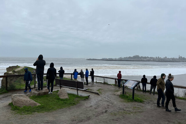
I watched the evacuation warnings and orders on Monday morning, including warnings for all of downtown Santa Cruz in case the river rose faster than expected and overtopped the levees. (The levees next to downtown have a paved multi-use path along the top, and there's a two-foot-tall concrete wall inside the path. Every branch on the path goes up and over the wall, just in case.) In Santa Cruz the river peaked at the "moderate" flood stage, but even at the highest flood stage the Weather Service noted that the water would still be below the top of the levees. The levees held, funneling the torrent of water out to the ocean.
By lunchtime the rain had subsided and the rivers had peaked. I went to visit the mouth of the river at my normal overlook, but I approached the overlook by parking along the street behind Oceanview Park (avoiding the straightforward route under the bottom of the levee, just in case) and walking down the hill and along the river.
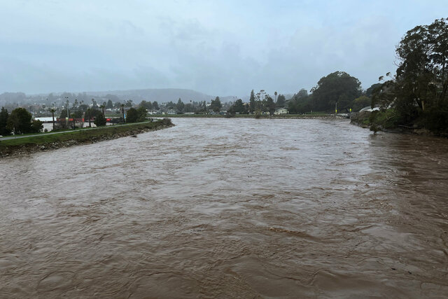
At flood stage, the San Lorenzo River was running wide and fast. It looked like chocolate milk, as if Willy Wonka's chocolate river had escaped the factory and were running through the middle of Santa Cruz at 10,000 cubic feet per second. (Augustus Gloop would have loved it.) The water was churning and carried logs and other debris from above; at one point I saw a red ball Christmas ornament float past under the bridge. The river smelled faintly of mud, though, which threatened the illusion.

Our house is perched on a hill at the edge of Santa Cruz, far above the flooding of the river. Our biggest threat would be a mudslide (I understand that the slope in our front yard did slide once before, twenty years ago), but we were able to avoid that particular problem. Highway 17 closed for twelve hours, cutting us off from the rest of the world, but we didn't need to cross the mountain, and neither did we get stuck on the wrong side of the mountain. The worst that happened at the house is the power blipped a couple of times, including while I was cooking supper one night. I had just put a pot of water on to boil, and it kept cooking when the power went out (because I still have a gas stove, which suddenly became a new front in the culture war, sigh); by the time I got the LED lantern down from its storage shelf above the fridge the power came back on.
The only damage that we suffered was that a small dead tree fell onto the driveway. The tree had been hanging over the driveway for as long as I can remember, and I thought about cutting it down, but it's on part of the driveway owned by one of the neighbors (with an easement allowing us to use it as our driveway). It's on the driveway side of the fence, so I think it belongs to the neighbor on the corner next to us, but the fences don't line up precisely with what I think are the property lines, so it might belong to the neighbor on the other side of the fence. I hadn't quite gotten around to resolving this uncertainty before the tree fell down in the storm. The tree was sitting off to the side of the driveway, leaving plenty of room to get around it, so I waited until the weekend, then took my reciprocating saw with a 9" pruning blade and sectioned the fallen tree into pieces small enough to fit in my compost. By the time my yard waste bin was full there were still two logs left from the base of the tree. The last two pieces disappeared sometime during the week, saving me the trouble of tossing them in my yard waste bin for the next week. There's still an ugly stump left where the tree broke off, but it's too big for my little reciprocating saw (and it's growing through the iron gate anyway, which is awkward) so I'll probably leave it as-is until the next time we have an arborist visit, then I'll ask them if they can trim the stump with a proper chainsaw.
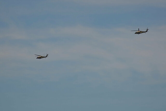
The next week President Biden flew across the country to tour the storm damage in Santa Cruz County. He landed in Air Force One at Moffett Field, took a helicopter to Watsonville, and then took a motorcade up to Capitola, then Seacliff State Beach in Aptos. I watched the live stream of his remarks on the beach at Seacliff, in front of the visitor's center next to the end of the now-destroyed pier. It was a little weird to see the President of the United States, and Governor Gavin Newsom, standing in a place I've visited multiple times in my own county, a short drive from my house. (And then he answered one question about the documents with classified markings found in his office and garage, a clip I heard replayed once or twice on news podcasts.)
An hour later I heard a throb of propeller aircraft and looked out the window to see a trio of Ospreys fly by, heading north over Santa Cruz from Monterey Bay. (It was hard to tell precisely what route they were flying, but it seemed like they were closer than the direct route between Watsonville to Moffett Field. Normally I'd check one or more open-source flight trackers, but these flights didn't show up for obvious reasons.) I ran upstairs in time to see a pair of VH-60N White Hawk helicopters flying along the same route. One of them, I assumed, must be flying with the callsign Marine One, carrying the President.
After three weeks of rain, starting the day after Christmas, the storm door closed and central California has been sunny and mild. I appreciate the water the series of winter storms brought California, and I also appreciate living in a climate where I can also count on direct sunlight in the middle of winter.
