Imberbus
Started: 2024-09-05 20:16:56
Submitted: 2024-09-05 23:24:12
Visibility: World-readable
Riding vintage Routemaster buses through an artillery training range on the Salisbury Plain to the involuntarily-abandoned village of Imber; also a side quest to an electropop show
I arranged my train trip to London to line up with this year's Imberbus, an event when scores of historic and current buses carry passengers to Imber, a village in the Salisbury Plain that was taken over as an artillery training ground in 1943. The artillery range is still used by the army, but it's open to civilians a couple of days a year; and on one of these days a bunch of people get to ride buses through the range because they can.

To get to Imber I had to take the tube (Northern line, Charing Cross branch) south from Camden Town to Waterloo, then catch a train to Salisbury. This was operated on a class 159 DMU, which was the first diesel train I took this trip. I could hear the deep purr of the diesel engine under my feet as the train pulled out of the station, and the insistent growl as the train throttled up to accelerate out of London on the South West Main Line towards Salisbury.

The train terminated in Salisbury, and I found the platform to wait for a Great Western service to Warminster. Soon it became apparent that it would be a tight fit in the two-car arriving train for everyone on the platform waiting for the train. (I don't know if they were all heading to Imberbus, but the one-day event did seem to draw a large crowd.) I found the right place on the platform to stand for the arriving train, and when it arrived, I joined the scrum trying to board the train and eventually made it onto the standing-room-only carriage. I didn't make it out of the vestibule in front of the doors for the entire ride to Warminster. It felt like an eternity standing in the crowded train but I think it was only twenty minutes.

I stepped off the crowded train in Warminster (no doubt to the great relief of the passengers who were traveling on to Bath) and found a line of old Routemaster buses lined up in front of the station, with a long queue of people stretching down the street in the opposite direction. I bought a bus ticket at the nearby ticket stand (£10 all day) and joined the end of the queue.

As I waited, inching forward towards the front of the queue, buses rolled by heading through Imber to various points beyond. (For reasons that are no doubt significant, every bus identified itself as route 23A, even though there were several variants of routes through Imber heading to several other villages and points of interest.)

I ended up on a bus heading to Brazen Bottom via Imber, and got a seat on the lower deck of the double-decker bus.

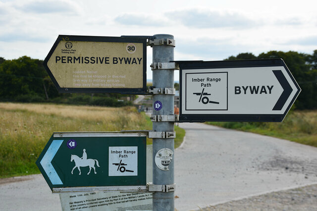
The bus pulled out of Warminster and headed towards Imber. On the outskirts of Warminster, opposite detached single-family homes, a tall fence topped with razor wire appeared, protecting what looked like the active military base on the opposite side. The bus climbed a hill (which I presume must be Sack Hill, since that's the name of the road and one of the waypoints given on the bus' destination board) and drove right through the signs reading "military firing range keep out" past the sign directing tracked vehicles through a different part of the gate and up to the main gate, which was open to the bus with a security guard waving us through.

Beyond the gate we continued to climb and our view expanded far beyond the road. Rolling hills stretched in every direction covered in grass with few signs of human civilization, aside from the carriageway we were driving on, and the frequent signs advising us that we were on an active firing range and that we should not leave the road for any reason lest we encounter unexploded ordinance. I spotted some misshapen lumps on the hillside, overgrown with grass, and soon realized that they were burnt-out armor, apparently used for target practice, with cows grazing around the hulks rusting away in the field.

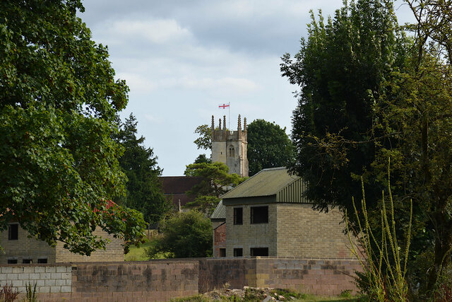
The bus pulled into the site of the village of Imber, now mostly overgrown except for new buildings built for training, and the old stone church. The people who lived in Imber expected to return to their village after the war, but the army hung onto the land and continued to use it for training and exercises.

The bus stopped in Imber to let people off and board more passengers before continuing on to Brazen Bottom. (I had only a vague idea where that was, but I decided to find out.) I stayed on the bus and moved to the front seat on the lower level, opposite the driver so I could look straight out the front window. We pulled out of the site of the village and onto the narrow road leading through the firing range and out the other side.

Beyond Imber I saw more rolling hills covered in grassy fields, occasionally with roads or tank tracks leading off into the hills. On the road we saw buses coming the opposite direction on the little road, which meant we had to back up to the nearest wide spot in the road to let the oncoming buses pass.

On the far side of the firing range we reached Gore Cross, which I want to call a village but it really looks like it's just a couple of farms and a handful of farmhouses. Around the corner from Gore Cross, down a side road with a sign indicating that it was intended exclusively for tracked vehicles, was a dusty clearing surrounded by fields that had been turned into a temporary bus stop, with buses dropping off and boarding passengers for various destinations. I stayed on the bus and continued to Brazen Bottom (which wasn't obviously a real stop, just a narrow road on the way to the next town), and finally to Market Lavington.

By this point it was early afternoon and I figured I should eat lunch, so I got off the bus in Market Lavington, which had a couple of streets of closely-packed two-story brick buildings and the Green Dragon pub. The pub marked on the Imberbus map, and was prepared for the extra traffic with a simplified menu, but the bartender warned that there was an hour wait for food. (Like everywhere else I visited in the UK, I paid with my contactless credit card at a wireless hand-held card reader.) I ordered anyway, and waited for a table in one of the cozy rooms in front to free up while I studied the old maps of the town decorating the walls. It turned out I only had to wait forty-five minutes for my veggie burger.

I caught a bus heading back to Gore Cross, following a different route through West Lavington to the bus station in the dusty clearing.

I got off the bus at Gore Cross and found the next bus to New Zealand Farm Camp. The bus station was arranged around a square in the middle of the clearing allowing buses to pull up to the outside of the square to drop off and pick up passengers. (A map in the guide indicated that buses to different locations would be boarding at different sides of the square, which was mostly correct in practice, but the actual boarding locations didn't quite line up with the practice. Instead there were people with bullhorns announcing which queue would be used to board passengers for which location.)

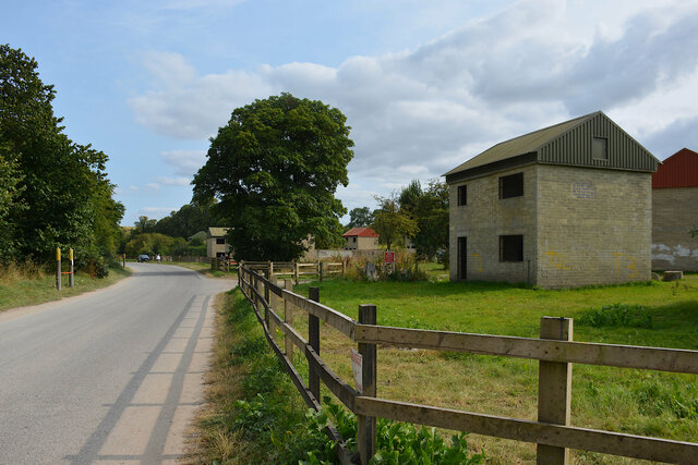
I had no real idea what to expect at a place called New Zealand Farm Camp, but I decided to find out. The bus stopped at the intersection of several roads, one of which was marked "Danger: No Public Access" and "Military Firing Range: Keep Out". There was a road down a hill terminating in a gate with some buildings behind it, which was built as an army training site in 2016, replacing a second world war training camp.

On the map it looks like part of the firing range continues to the east beyond Gore Cross, with civilian vehicles allowed to travel on permissive byways. Some roads were blocked, and all of the fields were marked with signs warning of unexploded military debris. I saw side roads designated for tracked vehicles, and it looks like these run for miles beyond Gore Cross.
I rode the bus back to Gore Cross and beyond to Imber. Along the way I took the picture below, and it looks like a photo that would illustrate a glossy magazine ad for a drug targeting active 60-year-old adults.

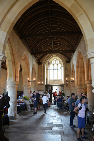
I got off the bus in Imber an walked up the hill to the old stone St. Giles Church. The church was fenced off from the surrounding firing range, with signs warning that it was strictly off limits. On my visit the gate and the church were open. Inside the church were light refreshments and some displays showing the history of the village of Imber.
I lingered in the church yard walking through the newly-mowed grass on the gentle hill above the church, dotted with tombstones and grave markers from the church's long history when the village was still inhabited.

I walked back to the main road and then along the road, past the concrete mock houses that were built in 1976 to train troops heading to Northern Ireland in house-to-house fighting and counter-insurgency.

The training ground looked like a crude simulacrum of the old houses and buildings that once lined the main street; and I took it as a reminder of the tensions still lurking in Northern Ireland that Brexit is threatening to uncover.
I walked down the main road and turned back to catch a bus back to Warminster.
The bus back to Warminster took me on the same route the bus took into Imber. I sat on the top level of the bus with a view of the countryside and the burnt-out armor lining the ridges opposite the road. When we pulled into Warminster I took one last selfie with the old Routemaster bus and headed down the street to catch the next train to Sailsbury.

The platform in Warminster was crowded with people leaving Imberbus, and I was briefly worried about the space on the train (especially because the monitors indicated that the next service was canceled and the following service was an hour later), but the Great Western service to Salisbury turned out to be operated with five passenger carriages, so there was plenty of room; I even got a seat. In Salisbury I got a snack at the convenience store inside the station, then caught the next train to London. I took the opportunity on the train to write my first blog post about the trip I was still on, finishing just in time as the train was approaching Waterloo.
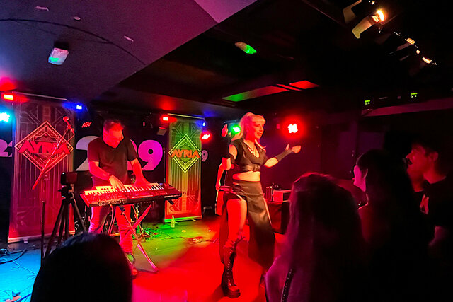
I caught the tube (Northern line, Charing Cross branch) to Camden Town, dropped my laptop bag in my hotel, and headed back out to 229 London, a live music venue around the corner from Regent's Park, to see Ayria. I arrived in time to see opening band Inertia. I knew basically nothing about either band, except that Ayria played in Glasgow the previous week while I was there, and I liked the sound of their electro-pop music but didn't manage to see them. It turned out we both headed to London at the same time so I got a rare second chance to see them; and I liked seeing both bands perform live in the cozy underground venue in central London.
"I've been doing this [Ayria] for twenty-one years," Ayria's lead singer. "Don't do the math on that. I started when I was five years old."
I took even more pictures in Imber and on the Salisbury Plain than I included above; they're all at Photos on 2024-08-17.
