Treasure Island
Started: 2024-09-12 21:02:24
Submitted: 2024-09-12 23:41:44
Visibility: World-readable
Crossing the Bay Bridge on bike (and bus), and riding an exciting new electric train
On Labor Day I biked across the New Bay Bridge, which first involved taking the train to Emeryville.
I arrived at San Jose Diridon station with just barely enough time to
park, detach my bike from the back of my car, pay for parking, buy a
train ticket, and board the 10:05 northbound eastbound
Capitol Corridor train. The bike car was the front car of the train,
equipped with racks to hang bikes vertically in the space that used to
be a luggage rack.

I sat at the front of the train, right behind the first two rows of seats that had been blocked off because the driver's cab door was open so I could look over his shoulder as we made our way across the salt marshes at Alviso, past the Cargil salt ponds outside Fremont, and onward through the suburban East Bay into the industrial part of Oakland laid out around the tracks and the port, before arriving in Emeryville.
I carried my bike across the pedestrian bridge over the train tracks at the station and headed south on Shellmound Street, past the Ikea in Emeryville (which was often my closest Ikea when I lived in San Francisco, though it depended on the traffic across the Bay Bridge; sometimes East Palo Alto was faster) to the trailhead of the Bay Bridge Bike Trail, tucked at the edge of the street under huge concrete freeway viaducts overhead and traffic streaming north on I-80 just on the other side of a fence. Signs next to the trail warned that the round-trip walk from there to Yerba Buena Island was multiple hours. (It looks close on a map, and it's not long in a car, but it turns out that maps can mislead and cars drive faster than a person can walk.)
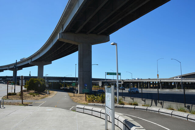
The trail wound its way under the elevated freeways feeding traffic to and from the Bay Bridge, routing around a water treatment plant and the Port of Oakland and a major rail corridor. Three East Bay freeways converge here to feed traffic to and from the Bay Bridge: I-80 to the north, I-580 to the east, and I-880 to the south (rerouted from its original path in the middle of a Black neighborhood in east Oakland after the double-decker Cypress Structure collapsed in the Loma Prieta earthquake in 1989). I-80 and the rail line sit on the ground; all of the other transportation infrastructure is elevated on a series of viaducts, some higher than others, like giant concrete flamingos perched on one leg.

The last stretch of the approach to the bridge ran along a straight flat section of path between the toll plaza on I-80 and the surface roads at the edge of the Port of Oakland. I turned off the bridge at the last moment to visit the observation pier that had been built in the middle of the concrete columns where the Old Bay Bridge met the land on the east side of the bay.
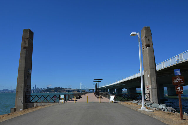
The last time I saw these columns up close was eight years ago when I biked across the not-yet-completed bike path along the New Bay Bridge. Then the lower bridge deck was still intact and was being used to slowly demolish the old bridge, one truss at a time. The first time I set foot on the New Bay Bridge was in 2013. The new bridge had only been opened for a couple of months and the old bridge was mostly intact

The only evidence of the Old Bay Bridge on this side of the bay were the two columns climbing out of the ground, and a couple of concrete piers used to support the new observation pier sticking out into the bay. There were a couple of interpretive signs explaining the history of the old bridge and the megaproject that replaced it.

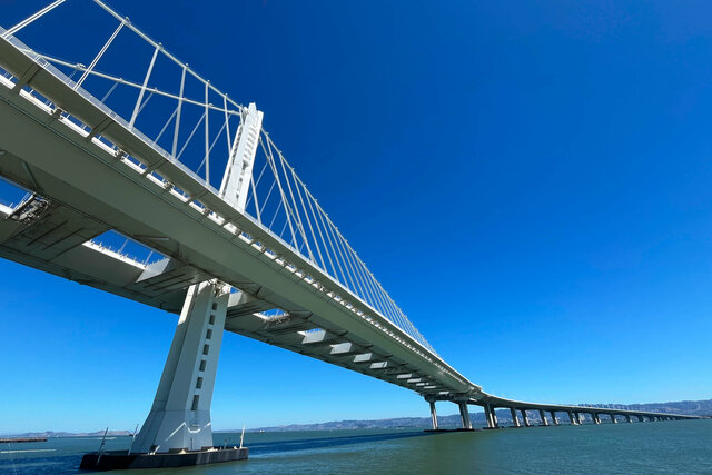
The end of the observation pier provided a view of the New Bay Bridge arcing gracefully across the bay to Yerba Buena Island, with the suspension spans on the other side of the island visible in front of the San Francisco skyline, now capped by the graceful taper of Salesforce Tower.

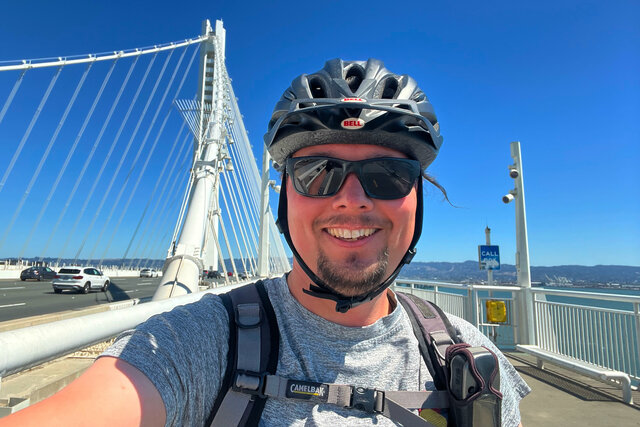
I biked back to the end of the bridge and began my crossing. The bridge climbed gently for a mile-and-a-half into the middle of the bay. The climb was so steady that I barely noticed it, except that I kept my bike in low gear, and the water grew slowly further away. It was a bright sunny day, with a light breeze; I stashed my cycling jacket and biked in short sleeves. Cars zipped past on the Bay Bridge, heading to the East Bay. I saw only a few people biking on the trail.

I stopped to get a picture at the high point on the bridge, the spot where the central self-anchoring suspension span joins the viaduct on Yerba Buena Island, which looked about like the spot where the bike path ended abruptly in 2016. Today the path finally goes all the way to Yerba Buena Island, and from there to Treasure Island.
The bike path dropped me off on a corner of Yerba Buena Island tucked away behind an onramp to the bridge and a fence protecting the Coast Guard installation on the southern side of the island. Google Maps wouldn't give me cycling directions from the bike path onto Treasure Island, but the map, and other online resources, seemed to indicate that it ought to work.

I followed the path onto a road that looked like it had recently been repurposed as bike infrastructure to a weird intersection directly below the bridge. I turned downhill, down Northgate Road, to the Bimla Rhinehart Vista Point, tucked under the bridge on the eastern tip of Yerba Buena Island, past the viaduct forming the western approach to the new bridge next to the massive concrete piers that are all that's left of the old bridge on the island. From below the bridge I could see that the bike path was cantilevered out from the main box girder that supported the bridge deck, in a manner that seemed like it was suspended precariously over the water.

At the end of the island, just above the water, was a small fishing pier that provided a powerful view of the new bridge looming above. Signs explained that various parts of the structure of the pier, including the trusses that supported tables and benches, were made from structural steel recycled from the old bridge.
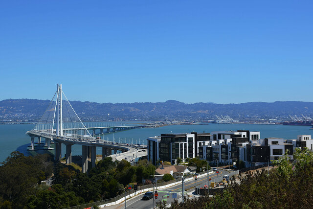
I biked back up the hill (it turns out that biking up my own hill at home has provided some acceptable training for climbing hills on islands in the middle of the bay), past the entrance gate to the Coast Guard station and buildings left over from the Navy bases on the islands. Both Yerba Buena Island and Treasure Island are now in the midst of huge redevelopment projects that promise to reshape them in the years to come. Yerba Buena Island is further along (and it's a smaller island, so there's less overall land to develop); there are several large and very new condo buildings along Macalla Road on the way around the island to Treasure Island. I biked past them, climbing slowly in low gear, and turned onto the road leading even higher on the island to reach the brand-new Panorama Park, featuring a spire named Point of Infinity located in a plaza built out of the foundation of a concrete-walled reservoir from the navy base on the islands.

From West Hilltop Plaza I could see in every direction: looking back to the New Bay Bridge and the East Bay to the east; north to Treasure Island; north-west to Alcatraz and towards the Golden Gate; west to the San Francisco skyline stretched out above the Embarcadero; south-west to the suspension spans of the Bay Bridge stretching from the opposite shore to the tunnel through the middle of the island that was nearly under my feet as I stood on top of the island. The park was comfortably full, with people wandering about mostly admiring the view, enjoying the sunny holiday afternoon at the end of summer.
While I was still on the island I failed to realize that there was a second, higher park at the end of a side road that looked like it was still under construction. (Large parts of the island are barricaded for various construction projects, and it wasn't always clear what was open and what I ought to expect to see.)

I biked down the hill from Yerba Buena Island onto Treasure Island, descending a very steep stretch of road that left me concerned about my brakes. There is even less to see on Treasure Island right now; much of the island is fenced off for residential towers under construction or planned on the artificial island in the middle of the bay.

My plan was to take the ferry from the island to the Ferry Building, and multiple sources strongly indicated that, because this was Labor Day and a holiday, the ferry was operating on its weekend schedule (with a departure from the island at 13:30, then a two-hour gap before the next trip) instead of its weekday schedule (departing at 13:00, then a two-hour gap). But despite the notice on the ferry's website, and the scrolling marquee right above the ferry's departure gate, the ferry departed on its weekday schedule at 13:00, while I was walking along the waterfront that hopes it will be a grand promenade one day.

There was nothing on the island to keep me occupied until the next ferry departure at 15:00, so I took the #25 Treasure Island bus from the front of the administration building to San Francisco. This involved placing my bike in the bike rack at the front of the bus, which made me slightly worried because I haven't used many front-of-bus bike racks and I could imagine doing it wrong and watching my bike fall off the bus while we were driving across the Bay Bridge. But nothing went wrong: the bus arrived and I pulled down the bike rack and placed my bike in the rack and pulled out the arm to hold my bike in place, then sat near the front of the bus so I could watch my bike as we crossed the causeway to Yerba Buena Island, climbed the hill up the side of the island, merged onto I-80 westbound, transited the tunnel through the middle of the island, and drove onto the bridge.

I do not often get to drive across the Bay Bridge, and when I do drive across the bridge I'm usually driving, so this was a rare opportunity to see Soma (including my old Google office) from a different perspective.

The bus exited I-80 on a ramp leading straight to the transbay bus terminal, through a series of bus-only gates that had ensnared a private vehicle that had apparently taken the wrong exit and read all the signs wrong and was being redirected to an exit ramp that was blocked by traffic cones. My bus dropped me off at the nearly-empty transit center, clearly built with capacity for far more buses than the small handful that were actually using the transit center on a holiday afternoon (that happened to be the second day of the Bell Riots in the city, according to a 30-year-old episode of Deep Space Nine). I rode an elevator to the ground floor with my bike and checked my map to figure out what I was going to do next: it was early afternoon and I hadn't eaten lunch, so I nipped down Mission Street to the Ferry Building and ate a couple of empenadas. (It was a new and interesting experience to be on the ground in Soma with my bike: I had much more mobility on the street (the half-mile from the transit center to the Ferry Building took almost no time; I was about as fast as a car with more flexibility) but I had to pay attention to parking my bike, and nipping on transit was somewhat more awkward.)
After lunch at the Ferry Building I biked down the Embarcadero to the Caltrain terminal at Fourth and King, which was much easier on a bike than via any other possible conveyance. The two blocks of King Street in front of Oracle Park where the bike lane spontaneously disappears was just as awkward as I remember from eight years ago (when I was living in a temporary apartment in Mission Bay when I first moved to San Francisco to work for Google, and biking to work along this corridor), but I remember how to bike in a city (be careful, take the space I need, don't be greedy, assume cars will be careless and bike defensively).
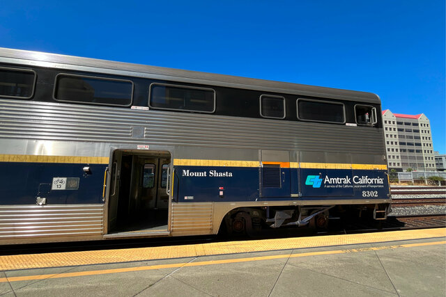
I joined the scrum of people waiting for the next southbound Caltrain service. Caltrain was running on the weekend/holiday schedule, so they were operating hourly all-stations trains compatible with their legacy diesel locomotive fleet. But Caltrain has started operating their fancy new EMU fleet ahead of their official transition later this month, and as I waited on the concourse I noticed that there was an electric train parked on one of the platforms in front of the sign indicating the next train to San Jose. The boarding gates opened and I saw the EMU doors were open and people were boarding the new train.

I found the bike car, stowed my bike inside (labeled with a destination tag because I was heading back to San Jose and Caltrain operates a bike stack data structure so they want people to be able to sort their bikes in the right order by destination) and stepped outside for a selfie on the platform with the shiny new train.

Inside the new train it was just like I saw last year at the Caltrain EMU open house: new, sleek, and clean. There were monitors that looked like they might be displaying travel information but some of them showed dead Chrome tabs and the others showed Caltrain logos. The seats were a little stiff and not overly comfortable, but they were adequate for my ride down the peninsula.

Caltrain was still operating on the old diesel-compatible schedule, so we stuck to the 100-minute trip from San Francisco to San Jose, rather than the new schedule that promises 80 minutes for the all-stations stopping service (twice an hour!) and 59-minute commute-time express service. At no point during the ride did it feel like we were accelerating at the rate we've been promised, or reaching reasonable speeds on the all-stations service. But it was exciting to ride the new electric trains for the first time, and I expect I'll get the chance to enjoy the new improved service in the future.

