Wardriving (take 1)
Started: 2004-08-14 20:45:46
Submitted: 2004-08-14 21:15:07
Visibility: World-readable
This afternoon, Bitscape and I wandered around Louisville and Lafayette (they're co-joined small cities in Colorado, just in case anyone was wondering) in Tobias with Elssbett, my GPS, and wireless card searching for wireless access points.
People:
Equipment:
- Elssbett, a powerful Dell Inspiron 7000 Pentium II 366 MHz.
- Garmin eTrex Vista and serial cable.
- Netgear MA111 USB 802.11b adapter. (I used a USB extension to set it on the dashboard in hopes of getting a better signal.)
- Tobias, a Plymouth Neon, circa 2000.
Software:
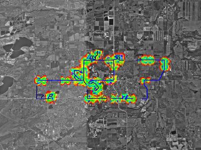
I spent the first fifteen minutes trying to figure out if Kismet was doing what I wanted it to do; once I found the log files (Debian tosses them in /var/log/kismet), I was happy. Until I was underway, I didn't discover that integrating GpsDrive and Kismet in real time requires MySQL, so I ended up running gpsd and watching the map in one window while Kismet sniffed (and logged) merrily away in another window. Bitscape and I spent about an hour and a half driving around, mostly in a bizarre figure-eight pattern. We found plenty of networks in the upper-middle-class neighborhoods we drove through, and even a few in bizarre places on otherwise-empty roads.

That map was generated using gpsmap, which is part of kismet. In theory, the colors are supposed to indicate the combined power of the wireless networks, although I abused the power interpolation feature (which is really supposed to be used with regular sampling throughout the area in question); I'm posting this picture mostly because I think it looks cool. The base satellite photography came from Terraserver. The incantations I used (since I'm fairly confident I'll want to know what they were in the future) were:
gpsmap -S 2 -d 1024,768 -s 14 --draw-power --draw-track /var/log/kismet/Kismet-Aug-14*.gps

