Comanche Peak Wilderness
Started: 2008-06-08 16:43:02
Submitted: 2008-06-08 18:05:27
Visibility: World-readable
Last weekend, Kiesa and I went camping for the first time this season, the first in what I hope will be a long series of outdoor expeditions this summer. Once we finished packing, Kiesa and I headed through Fort Collins to the Cache La Poudre River, then turned off the main highway to join the Little South Fork at Pingree Park, surrounded on three sides by Comanche Peak Wilderness, on the north-east side of Rocky Mountain National Park. (I found the wilderness in my wilderness guidebook and thought it would be an interesting place for the season's first expedition.) We camped at Tom Bennett campground. The campground only had twelve spaces, and I wasn't sure how fast they would fill up on a Friday evening at the beginning of summer. There were still spaces left, and there were spaces open each night.
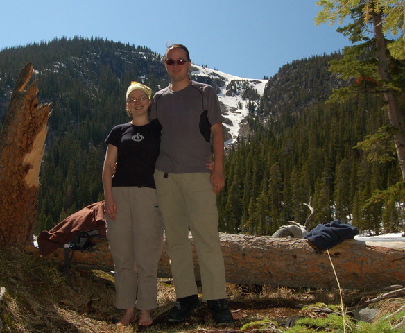
We arrived around eight and set up the tent before night fell. We had some new gear to try out on this trip: Kiesa acquired a sleeping bag that was a mirror image of mine, allowing us to zip the two together. This worked reasonably well. I also acquired a LED lantern that looks small enough to take backpacking that gave enough light to see well in the tent. (The one thing I missed was a reasonable scheme to hang it from the tent's ceiling, though I did manage to suspend it from the overhead netting. I also underestimated the number of rechargeable AA batteries I would need for the entire trip.)
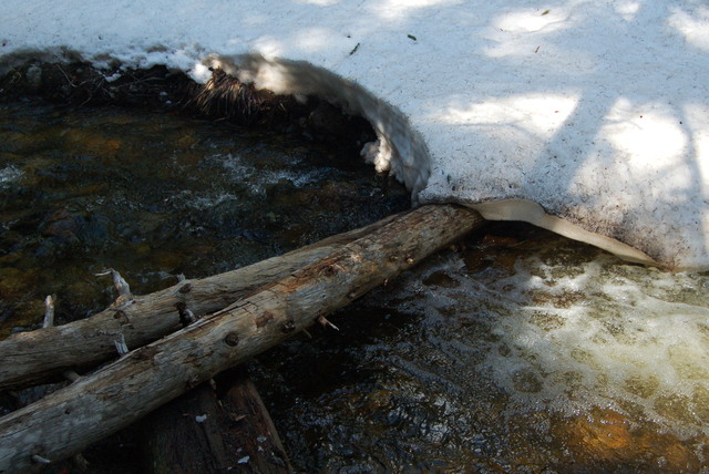
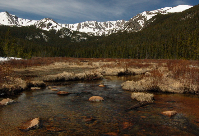
On Saturday, we set out on foot from the campground, heading generally west along the Forest Service road but diverting twice to avoid the Sky Ranch Lutheran Camp and Hourglass Reservoir. We continued west along the north shore of Comanche Reservoir and eventually entered Comanche Peak Wilderness. At the appropriate junction, we turned south, crossed Beaver Creek, and prepared to climb 500 vertical feet in a mile to reach Comanche Lake. As soon as we crossed the creek, we hit snow at 9500 feet on the sheltered north-facing slope. Finding the trail was tricky under three feet of snow; post-holing through the soft snow made merely walking down the trail difficult. i eventually cobbled together enough clues from downed trees cut to make way for the trail, and from faint blazes carved into the trees. We decided we were too close to the lake to turn back now; plus, we could see what looked like human tracks with an interesting boot print and occasionally what looked like a dog's track, plus clumps of hair apparently being shed by the dog. As we hiked up the side of the valley, I lost and regained the trail once and generally followed the direction provided by my GPS receiver. I finally lost the trail for good somewhere in the vicinity of the creek crossing. The map on my GPS receiver was no help; I was close enough to Rocky Mountain National Park that I did have the park's 24,000:1 topographic maps on my receiver, but the trail registration on the maps is not suitable for navigating the trail without other assistance. (The maps generally indicate where the trail goes, within a hundred-meter-wide corridor, but that wasn't much help when I could barely tell where the trail was when I was standing right on top of it.) I found a snow-covered fallen log to cross the creek. I was able to cross without too much trouble but Kiesa slipped off the edge of the log, scraping her leg against the log, leaving an impressive bruise. We entered a marshy area just below the lake, which meant almost no snow but ankle-deep water. Our boots were pretty much drenched by that point, but my boots went above my ankles and Kiesa's only went to her ankles.
An hour and a half after turning onto the snowy slope, we finally emerged from the forest at Comanche Lake. The lake was still frozen over and provided only minor views of the surrounding mountains, but I was happy to accept it as my destination for the day. We found a sunny spot to eat lunch and try to dry out our shoes and socks. We were able to wring water out of our socks from the snow that melted in our boots; we set our shoes and socks in the sun to dry, which was somewhat less effective than we hoped.
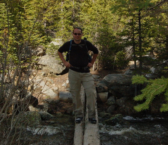
After some mini-tripod-assisted pictures of us at the lake, we headed back down the mountain and tried to figure out where the trail joined the lake. Kiesa spotted a sign visible only from within a snowbank, which seemed like a reasonable place for a trail. That was enough to help me find where the trail left from the lake. Going downhill was easier than going up for several reasons. Our shoes were already drenched, so being a bit less cautious about where exactly we stepped wasn't going to hurt very much. For much of the trail, I could simply follow our tracks downhill without bothering to route-find. (It also helped that simply going downhill was easier in general since gravity was working with us and not against us.)
Not long after departing the lake, I realized that the tracks we had been following up the trail were not in fact human tracks at all; they were the tracks of a moose or elk following the trail downhill from the lake. This was easier to see when traveling downhill because the individual hoof prints were more visible from the uphill side of the track. What I had taken for human prints were in fact all four of the land mammal's legs stepping in roughly the same space. I concluded that the shed hair had in fact come from this animal, and that it may have been pursued by a predator at one point. (I was insufficiently well-versed in my northern Colorado predators to determine whether the four-toed, two-inch-wide paw print I saw was canine or feline.)
Back at the creek crossing at the bottom of the valley, we left the snow for good and took the opportunity to wring out our socks once again. (I was distinctly sloshing halfway down the trail from the lake.) Kiesa spotted a moose in the creek behind me and alerted me to turn around slowly, but I wasn't slow enough to keep the moose from getting scared and running off as I tried to get my camera out. The one under-exposed shot of the river that I managed to get didn't actually show anything. I briefly spotted another moose on the trail a kilometer down, before leaving the wilderness, but wasn't able to get a shot of it either.
The trail back to the campsite was longer than it had seemed on the way up. By the time we made it back, we had hiked something on the order of fourteen miles round-trip, which was a bit further than I had intended but not outside the realm of hikes I want to be able to take this summer without feeling too many ill effects. I was happy to be able to change my socks and set my boots out in a desperate attempt to let them dry.
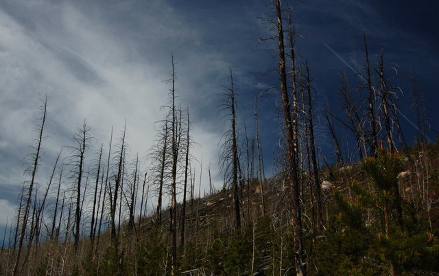
On Sunday, we broke camp and drove up the road to the Emmaline Lake Trailhead. We hiked west from the trailhead along an old logging road, through several sections of forest burned by the 1994 Hourglass fire. (I was pleased with myself when I spotted the burn area while looking at the terrain in Google Earth and correctly recognized it as a burn area, at which point a quick search revealed the date and identity of the fire. On Thursday before the camping expedition, I visited the Boulder Public Library's microfilm room to read newspaper articles from the fire for the Wikipedia article I plan to write on the fire.) Three and a half miles up the trail, we reached Cirque Meadows, which my guidebook called "a fine destination in its own right". The trail continued past the meadow, but beyond the meadow we started post-holing and decided it really wasn't worth it to get to Emmaline Lake, especially after our experience the previous day. (We did talk to one guy who had made it all the way to the lake yesterday; he reported post-holing on the softer snow at lower elevations until the cooler temperatures of higher elevations took hold and made it easier to walk on top of the snow.) We turned around and headed back to the car, then headed down the road to Cache La Poudre Wilderness.
Cache La Poudre Wilderness was another northern Colorado wilderness I hadn't previously visited. Being at a lower elevation than Comanche Peak Wilderness, it seemed like a good bet when thwarted by snow above 9500 feet. We ate lunch at the picnic area along the Cache La Poudre River, then hiked the four-mile Mount McConnel trail, which climbed 2000 feet in two miles to the summit overlooking the rugged Little South Fork of the Cache La Poudre River canyon, downstream of where we spent the weekend. My boots were still wet, which made my socks wet and gave me a pair of nasty blisters on both feet. When we made it home, after our exciting weekend adventure, I had to wear sandals indoor to keep my blisters in check.
As the first major expedition of the summer, I expect more to come.
