Coney Lake
Started: 2008-06-18 21:52:20
Submitted: 2008-06-18 22:21:56
Visibility: World-readable
Last Wednesday (11 July 2008), I took the day off work for a fact-finding mission to see how much snow was on the ground at 10,000 feet. My mission took me to Beaver Reservoir, which I visited recently for geohashing. The day was cool and overcast; it was flurrying as I parked at the still-closed gate at the Coney Flats four-wheel-drive road.
I set out on foot along the Coney Flats road, which had dried out significantly in the two and a half weeks since my last visit. I didn't see any snow at all until after I rejoined the four-wheel-drive road after the hiker-only shortcut. I had to navigate some significant ponds on the road, which made me glad I was wearing my waterproof boots. By the time I reached the wilderness trailhead and the wilderness boundary, the I had only traversed snow to avoid wading through water.
Inside Indian Peaks Wilderness, the situation changed. Within a few hundred meters, there was enough snow on the trail to warrant wearing the snowshoes strapped to my pack. This soon proved to be a bad idea; the snow was spotty enough that I spent much of my time walking over dirt in snowshoes, and where there was snow it was packed well enough that I didn't need much flotation. (It didn't help that the snow was drifted up and down to the point where I was having trouble getting a foot hold in snowshoes.) After a few hundred meters, I gave up on snowshoes and relied on my gaiters to keep the snow out of my boots. As I climbed through 10,000 feet, the snow firmed up to the point where I could walk on top of it without sinking. At that point, my primary difficulty became finding the trail. I think I followed it half-way up the valley from the trail junction to Coney Lake. After that, I knew I was nowhere near the trail but I didn't have a good idea where the trail really was. I used my GPS and a custom-printed 24,000:1 topographic map to figure out where I was, then extrapolated that point onto the Trails Illustrated map that actually had the trail I was trying to follow, which gave me a vague idea where I was supposed to be. I generally headed up the valley in the direction of the lake and managed to find the trail in a few places, only to promptly lose it again.
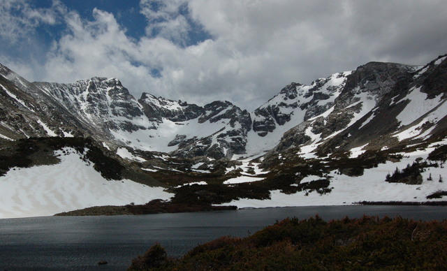
I hit timberline just below Coney Lake. I ate lunch overlooking the lake, trying to withstand the frigid wind blowing down the valley. I left after one bagel and headed back down the mountain. I started out trying to follow the trail back down but soon gave up and simply followed my tracks, which at least took me back to known good trails. I was pleased with the ability of my gaiters to keep snow out of my boots, and pleased that they didn't soak water up my legs. I retraced my steps out of the wilderness, across the lake spanning the wilderness trailhead, and ultimately back to my car parked at Beaver Reservoir. I saw the only two people I had seen on the trip as I hiked back on the hiker-only shortcut on the four-wheel-drive road.
I returned to civilization refreshed from my mid-week wilderness adventure as I tried to figure out how my on-the-ground information about snow conditions would affect my backpacking plans for the weekend.

