Richmond (and the ferry)
Started: 2023-08-22 20:34:46
Submitted: 2023-08-24 21:52:53
Visibility: World-readable
Taking the bus across the mountain; visiting Richmond (the city in the East Bay); riding a ferry across the bay; visiting my old neighborhood Ingleside
Santa Cruz is blessed with many things, but good transit connections to the other side of the mountain is not one of them. (We can't even manage good transit on this side of the mountain, but that's another story.) But poor transit connections are not precisely the same thing as no transit connections, so I figured that I ought to try to ride the one bus line heading across the mountain just to see what it was like.
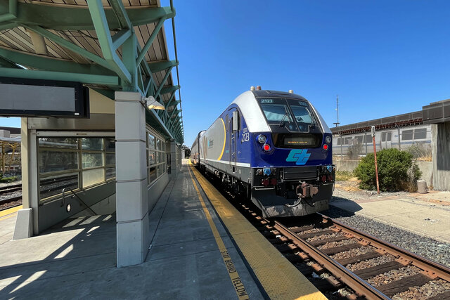
Santa Cruz Metro has one bus line connecting us to San Jose, conveniently named #17 after the state highway it follows. It operates as an Amtrak connection, with a schedule that sort of lines up to the Capitol Corridor interurban service connecting San Jose to Sacramento. This meant that I could buy a single 'train ticket' with connecting service to modest list of cities in the East Bay (and further north), which is probably as good as I'm going to get as long as I live in Santa Cruz. (It seems unlikely that Santa Cruz will ever get its act together and figure out what to do with the legacy branch line leading to Watsonville, never mind that a branch line to Watsonville is not the most effective way to get to most places.)
I spent Saturday morning, the 5th of August, getting my bike into shape so I could ride to Calvin's new high school and (most importantly) escort Calvin there to show him the route so he can ride there himself. I confirmed that the route to school is reasonable on a bike, and that my bike is in good enough shape that I can escort Calvin there, and also that our hill is brutal on a bike. (Our hill climbs 175 vertical feet in 2000 horizontal feet.) Even with my bike in its lowest gear I had to stop half-way up to catch my breath before I could proceed.
With that important bit of parenting prep completed, I drove to Scotts
Valley to catch my train bus to San Jose. (I started in
Scotts Valley because there's ample parking at the Cavallaro Transit
Center, though I needed to find the right app to pay for overnight
parking.) The #17 bus arrived (a few minutes late) and I boarded and
settled in for my ride across the mountain and into San Jose.
The timetable gave me a 15-minute transfer at San Jose's Diridon station, but my bus arrived late, giving me just enough time to walk from the bus to the train platform (after sticking my head into the station's waiting room to figure out which platform my train would be departing from). I caught Capitol Corridor train #732, departing San Jose at 13:05, heading north towards Sacramento.

The train took me across the southern end of the San Francisco Bay and onward up the East Bay, with a weird jog at Fremont. I got a snack in the cafe car and watched the East Bay roll by as we traveled north. I got out when the train stopped in Richmond (the city in the East Bay, not the neighborhood of San Francisco or the city in Virginia), then stopped on the narrow platform to watch the diesel locomotive at the back of the train push the passenger carriages northward towards Sacramento.
(On the socials media I found a meme featuring a plush Amtrak locomotive named Mr. Honk-Honk, so this was my chance to see Mr. Honk-Honk in his natural habitat. Though my train's favorite call, when approaching level crossings, was Hooonk-Hooonk-Honk-Hoooonk.)
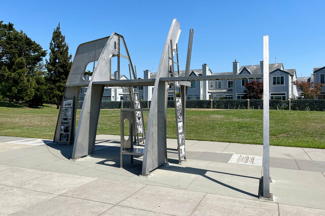
The Amtrak station in Richmond is conveniently collocated with the BART station (at the north end of the East Bay trunk line), next to a large transit center, but I wanted to visit the Rosie the Riveter National Historical Park, so I waited for AC Transit bus #74 to take me to the marina in the inner harbor. (This bus took my Clipper card, as is right and proper for transit agencies in the Greater Bay Area.) I found the Rosie The Riveter Memorial in the middle of a grassy field in a city park, a stylized up-side-down outline of a section of a ship's hull, with pictures of the women who built the ships and some text putting the pictures in context. The sculpture was laid out with exactly as much distance between the sculpture and the edge of the water at the inner harbor as the length of a liberty ship's keel.
I walked around the inner harbor, past the small boats docked at the marinas in the basin, to the visitor's center that forms the core of the historic park. (The whole historic park is made up of a handful of sites around the city of Richmond that are hard to get to without a car; I made a strategic decision to only visit the visitor's center since I was trying to make my way around on transit.) I arrived in time to watch one of the movies on rotation, putting the Kaiser shipyards in their historic context, then made my way through the exhibits inside the museum. This was one of the shipyards that the federal government funded to churn out ships during the Second World War, effectively spamming the North Atlantic with more shipping than the German U-Boats could sink. (I was bemused that Kaiser got a contract to build ships before he had any actual experience building ships, which reminded me of some of the government contracts awarded for PPE and other supplies during the first months of the COVID-19 pandemic; though Kaiser's shipyards proved to be a good investment.)

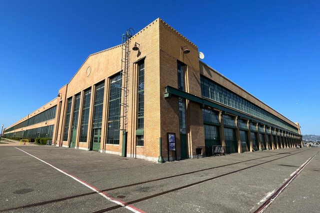
Next to the museum was a restored shell of a Ford factory, originally built on the site before the war and converted to produce military vehicles. It was abandoned after the war, damaged by the Loma Prieta earthquake, and threatened by demolition before it was restored to serve as an events venue.
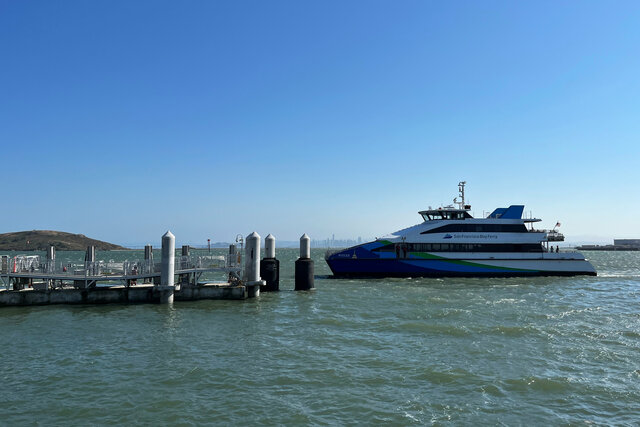
Opposite the Ford factory was the ferry dock, where a ferry pulled up right on time to take me across the bay to San Francisco. I arrived just ahead of the crowd that gathered to catch the ferry (giving me the opportunity to be the first passenger to step on board the ferry). The ferry dock was entirely unstaffed except for the crew of the ferry, who disembarked to tie the ferry to the dock and open the doors to let the arriving passengers disembark and then the departing passengers embark on the ferry.
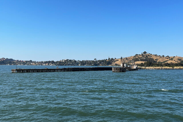
Our route took us past SS Red Oak Victory, a restored "Victory" ship now serving as a museum ship docked in a berth next to slips used by working ships, in between docks where imported cars are driven off their cargo ships into huge parking lots before being driven onto car carrier train cars to be pulled across the country. (I learned that Victory ships were an improvement on the Liberty cargo ships, built in smaller numbers near the end of the war.)
We cruised past Point Richmond as I stood on the open-air second deck to get the best view. The working vehicle docks quickly gave way to upscale waterfront condos (and a handful of houses perched right on the water, which seemed like a poor decision in the face of rising sea levels driven by anthropogenic climate change). Then there was a derelict warehouse at the edge of the water, and finally a railroad pier at the end of Point Richmond, originally used to ferry rail cars across the bay to Mission Bay, rather than take the long trip all the way down the end of the bay through Alviso and back up the peninsula to San Francisco.
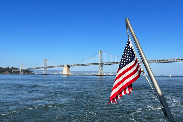
My route across the bay on the passenger ferry was fast and easy. After we passed Point Richmond and cleared the breakwater protecting the harbor, we turned south and opened up the throttle to speed down the open water in the middle of the bay. Standing on the open-air deck at the back of the ferry I was protected from the wind by the body of the boat ahead of me, but if I leaned too far out the wind was strong enough to take my breath away. (The GPS app on my phone indicated that we were cruising at about 30 knots.) The afternoon sun glinted off the water. I watched as we passed the Tiburon peninsula and Angel Island, and saw in the distance over the glare of the sun on the water the Golden Gate and the vast Pacific Ocean beyond. We passed Alcatraz and then lined up to dock at the Ferry Building.
I caught an F historic streetcar, packed with tourists, to Union Square, then checked into my hotel for the night, Parc 55, currently in the news in San Francisco for having the misfortune of having an expensive mortgage that its operator is trying to unload by giving it back to the lenders. (I have no idea how well this will work for them, but I got a good rate so I decided to stay the night there.) This happened to be the first time recently that I've been in Union Square without taking BART there (I ended up taking a bunch of other transit instead).
I caught BART to the Mission and ate supper at Cha Ya (my favorite vegan Japanese restaurant in the Mission, which seems like superlative creep but isn't because it's one of my go-to places), then walked around Dolores Park before return to BART to Balboa Park.
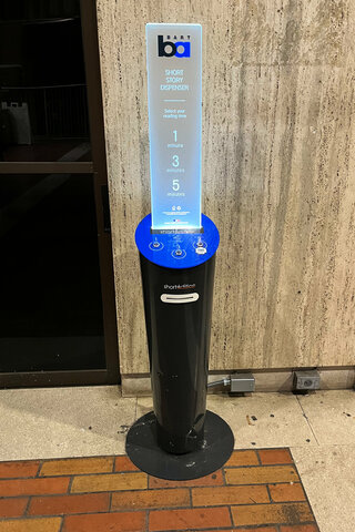
On the upper concourse I spotted a short story dispenser, which appears to be something of a public art project by BART itself. I waved my hand over the sensor for a one-minute story, and the machine whirred to itself for a moment before spitting out a two-foot-long story thermal-printed on receipt paper. I briefly glanced at it before stuffing it in my jacket pocket to read later; but by the time I looked for it later the story was gone, apparently having fallen out of my pocket sometime after I received it. I guess I did get a story out of the dispenser after all, it just wasn't the story that I was expecting.
In the five years since I've stepped off a train at Balboa Park BART station, a sprawling low-rise apartment building has sprung up in what used to be a surface parking lot on the south side of the station. (The building is new enough that the satellite photo on Google Maps still shows the construction crane towering over the building; on my visit it looked like it wasn't quite open yet but was getting close, but still had its new concrete smell.) I had to walk around the building to get to San Jose Ave to cross I-280 and turn on Mount Vernon Ave, following the route that I used to take every day except for the detour around the construction.
I turned up Louisburg Street and climbed the hill to the house where I used to live. I haven't seen it for five years, and sometime in those five years it had been painted gray and acquired a couple of planters out front that held some struggling succulents.
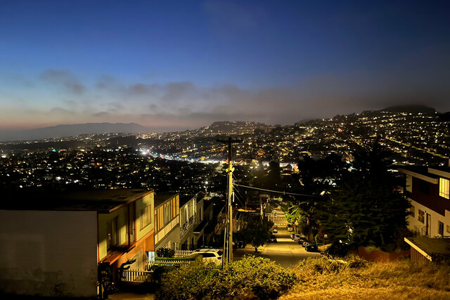
I crossed the street to walk up Ridge Lane then walked around the corner to walk up Lakeview Ave, gently climbing the nameless ridge running between the neighborhoods of Ingleside and Oceanview. It was after sunset, but still twilight, and the sky was mostly clear but the air held a hint of fog from the ocean nearby.
Lakeview Ave ended with a sudden steep climb to dead-end at Lakeview and Ashton Mini Park, capped by a house-sized outcropping of the local bedrock surrounded by some scraggly grass forming the local high point for this corner of the city. The rock interrupted the road grid; quiet residential streets descended in four cardinal compass directions from the summit. I could see the lights of suburban San Francisco spread out on the hills in every direction: the bright strip of Ocean Ave and Mount Davidson shrouded in fog to the north; Excelsior and the San Francisco Bay to the east; Daly City's little boxes of ticky-tacky lined up on the hill on the flank of San Bruno Mountain to the south; and Parkside and the Pacific Ocean to the west.
This was one of my favorite places to visit when I lived in San Francisco.
I sat on the summit for a while, feeling the breeze from the ocean; then I descended the concrete streets of Ingleside to the K-line tram running down Ocean Ave to return to my hotel in Union Square for the night.
