Lower Mummy
Started: 2014-07-28 21:15:59
Submitted: 2014-07-28 22:49:33
Visibility: World-readable
In which the intrepid narrator climbs Mummy Mountain and Hagues Peak, finishing his goal of climbing the top highest peaks in Rocky Mountain National Park
Five years ago I came up with the bright idea to climb the ten highest peaks in each of my nearest protected mountain areas: Rocky Mountain National Park and Indian Peaks Wilderness. I didn't want to go to the trouble of climbing every little mountain, since I do have a day-job, but I figured the top ten list ought to keep me busy for a while, especially since I spent half of my time climbing other interesting mountains that weren't officially on my top-ten list.
For most people, myself included, climbing mountains in Colorado is strictly a summer activity. In 2009 I climbed Mount Alice (ranked tenth; 13,310 feet), Mount Meeker (ranked second; 13,911 feet), and Longs Peak (ranked first; 14,259 feet). In 2010 I climbed McHenrys Peak (ranked ninth; 13,327 feet) and Ypsilon Mountain (ranked fifth; 13,514 feet). In 2011 I climbed Chiefs Head Peak (ranked third; 13,579 feet) on a beautiful autumn day. In 2012 I didn't climb any mountains in my local national park, though I did have some great climbs elsewhere in Colorado. In 2013 I climbed Fairchild Mountain (ranked sixth; 13,502 feet) and Pagoda Mountain (ranked seventh; 13,327 feet). That left two mountains remaining: Mummy Mountain (ranked eighth; 13,425 feet) and Hagues Peak (ranked fourth; 13,560 feet).
The two remaining peaks on my list are in the Mummy Range, a short string of peaks on the northern end of Rocky Mountain National Park that sort of looks like a reclining mummy when viewed from the right angle with enough imagination. The peaks also happened to be right next to each other, so I decided to climb them together. Either of these peaks individually would be a long hike; together my route covered eighteen miles.
I set out early on Saturday morning, 12 July 2014, and drove up US 36, through Estes Park, to my local national park. (Have I mentioned that one of the things I love about living in Boulder is being able to casually drop by one of the most scenic and popular national parks?) Large chunks of US 36 were washed away by the flood last September, and now that summer has returned CDOT has replaced most of the temporary road with a new, wide, somewhat-more-flood-resistant permanent road.
I parked at the Lawn Lake Trailhead and hiked toward the lake, and turned onto a connecting trail before reaching the lake to begin climbing the edge of Mummy Mountain. I spotted a cairn roughly where I expected to leave the trail and turned north to climb straight up the south ridge of Mummy Mountain. As I climbed through treeline onto the gentle tundra above I cast a wary eye to the clouds gathering in the west. The forecast called for storms "mainly after 1:00" which meant there was no guarantee that it wouldn't storm before 1:00, but the clouds looked like thin rain clouds, not massive thunder heads, so I decided to continue my climb.

The south slope of Mummy Mountain seemed never to end, despite a few false summits, but I eventually reached the summit a little before 11:00. Most of the foothills and the plains beyond were covered in low-lying clouds, but I had sun at 13,425 feet. To the north and east the mountain rolled gently away into treeline far below; to the south and west the mountain dropped into cliffs above Lawn Lake. Far to the west I could see the yellow volcanic Never Summer Mountains, always looking a little out of place among the granite that makes up the rest of the park. I signed the summit register (a slightly-damp laser-printed topographic map of the area) and set my sights to Hagues Peak to the west.
I descended the north slope of Mummy Mountain, traversing the ridgeline connecting Mummy Mountain to Hagues Peak. As I picked my way down the boulders I encountered another climber -- only the second person I'd seen all day, after a grizzled guy not far from the trailhead -- who had climbed up from the backcountry campsites at the lake and asked about the terrain on the other side of the mountain, which I'd climbed up. He said he was from North Carolina and wasn't used to the mountains being quite so rocky. "Well," I said, "they are the Rocky Mountains." (His hat bore the letters "NC"; I resisted the urge to point to my hat and say, "I'm from LTE.")
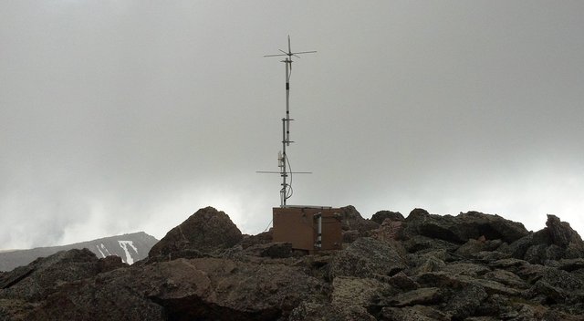
The east ridge of Hagues Peak proved to be as rocky as one might expect given the name of its mountain range. The microwave-sized boulders gave way to piano-sized boulders, and as I approached the top of the peak, it started to hail. The hail soon gave way to rain, which mostly served to make the rocks slick under my boots. I glanced to the north at Rowe Peak and the adjacent glacier, then found myself on top of Hagues Peak with only the wind and an unmarked radio antenna for company. I did not spot a summit register, but I didn't try very hard to find one.
The rain let up for my descent, but the clouds remained and the rocks stayed wet, making the down-climb to The Saddle a delicate affair. The rocks eventually gave way to rich grass, which proved much easier to walk on. By the time I reached the trail, the sun was out.
From the trail it was a short eight-mile hike back to my car at the trailhead. I descended the trail down the end of the alpine valley to Lawn Lake, then down into the trees to descend through the valley as it turned broadly to the south. I was getting tired; I could keep up a pretty good pace going downhill or flat, but when the trail forced me to climb my pace dropped. Once I was safely below treeline a series of thunderstorms rolled in, one with an ominous cloud-to-cloud lightning strike not more than a second away. Almost as bad as the electrical storm was the irregularity of the rain: it'd rain heavily for five or ten minutes, then stop for just long enough for me to get hot in my rain coat and take it off before starting up again.
At length I reached the trailhead and put my eighteen-mile hike behind me, having successfully climbed the last two of my objectives in Rocky Mountain National Park.
